Solar Eclipse Thursday Morning Long Island Weather Outlook Weekend & Long Range

Weather in 5/Joe & Joe Weather Show Latest Podcast
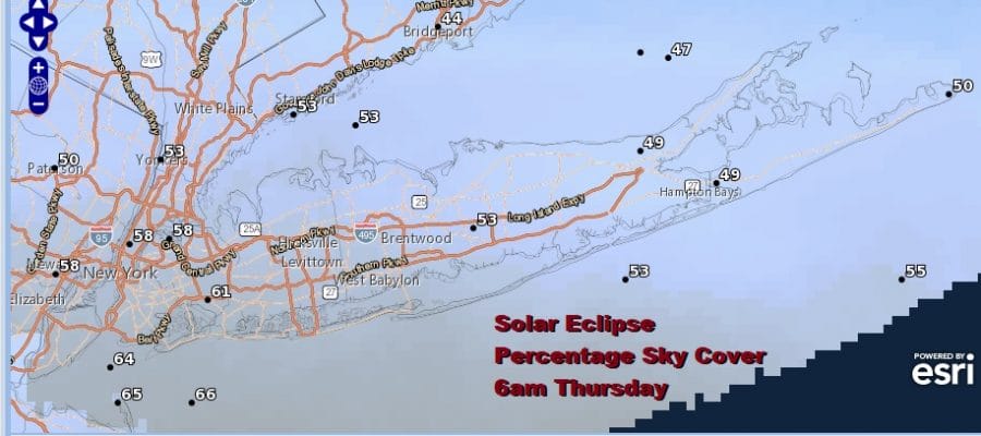
Solar Eclipse Sunrise Thursday Cloud Cover Forecast Weekend Outlook
Thursday is the day for the solar eclipse and it will occur at sunrise. Long Island may be in a good spot for this because most of the cloud cover forecast is going to be to the west and south. Dry air in Upstate NY and New England will move in from the northeast and that should leave the eastern sky with far less cloud cover. The eclipse occurs at sunrise so you want to be up at 5am to see this.

Depending on where the clouds are it could make for a beautiful spectacle with all sorts of colors especially if there is a little haze around. Remember to use eclipse safety glasses for safe viewing. After 6am the eclipse will come to an end. Meanwhile we have clouds around filtering the sunshine this afternoon. Winds have gone around to the northwest and temperatures are in the upper 80s this afternoon. A few spots could touch 90 degrees. As a cold front approaches it may trigger off a scattered thunderstorm. The wind is in favorable direction for thunderstorms to survive as there is no ocean wind today except right at the immediate coast.
SATELLITE

Once the front passes it will stall out to our south across Southern New Jersey on Thursday. We will have lower humidity and sunshine for Thursday. Highs will be in the mid to upper 70s. Some warm spots could see 80. Humidity levels will come down as the day wears on.

LONG ISLAND LONG RANGE WEEKEND AND NEXT WEEK
The developing low offshore on Friday will be well to the south and east and that low pulls cool dry air southward. Most of the area will see sunshine Friday Highs will be in the low to mid 70s. The weekend is look ok for the most part. Saturday we will see some sunshine. Highs will be in the mid to upper 70s.Sunday a cold front will approach. It should be dry most of the day with a chance for some thunderstorms late in the day. Highs will be in the upper 70s to lower 80s. Another front arrives late Monday with a chance for showers and thunderstorms. Next week looks to be rather cool for this time of year as a strengthening jet stream from Canada brings upper air northwest winds as far south as Georgia. This will leave us in below normal temperatures along with low humidity for much of next week.