
Snow Removal Overtime In Chicago!
Snow removal crews are out in Chicago. The midwest storm is strongly outperforming in and around Chicago. Cold air and a wind of the lake is enhancing snowfall.. Snow forecasts for the area have been raised from 2 to 4 inches to 6 to 12 inches as the radars there are impressive. Some stats about Chicago should make snow lovers here happy. Despite the warm month, Chicago is seeing its first inch of snow 12 days earlier than average.
Trace or More
| Average Date: | October 30th |
| Earliest: | September 25, 1942 (Trace) |
| September 25, 1948 (Trace) | |
| Latest: | December 5, 1999 (0.1 inches) |
Measurable (0.1 inches or more)
| Average Date: | November 16th |
| Earliest: | October 12, 2006 (0.3 inches) |
| Latest: | December 16, 1965 (0.3 inches) |
One Inch or More
| Average Date: | December 2nd |
| Earliest: | October 19th, 1989 (3.8 inches) |
| Latest: | January 17, 1899 (1.0 inch) |


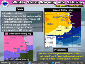
Snow won’t be tapering off there until tomorrow afternoon. Temperatures are borderline it is a heavy wet snow that is falling and Winter Storm Warnings are posted for not only Chicago but for Milwaukee and much of the southern half of Wisconson into Northern Illinois. Not bad for a storm that has no gulf moisture to work with. Dynamics plus cold air and a wind off Lake Michigan seem to be doing the trick quite nicely.
This weather system will be pushing a cold front through our area Sunday morning and there could be a rain shower in the early morning hours on Sunday. Behind it temeperatures will fall and reach the mid to upper 20s in many areas by Monday morning.
CHECK THE LATEST FROM THE NATIONAL WEATHER SERVICE OFFICE IN CHICAGO
LATEST FROM THE NATIONAL WEATHER SERVICE MILWAUKEE
WINTER STORM WARNINGS FOR PARTS OF THE MIDWEST PLUS OUR SHORT RANGE WEEKEND FORECAST
JOESTRADAMUS ON WARM NOVEMBERS AND WHETHER THEY MEAN SNOWLESS WINTERS
JOESTDAMUS ON THE SPLIT FLOW AND SUBTROPICAL JET
JOESTRADAMUS LATEST ON THE LONG RANGE
JOESTRADAMUS ON TYPHOO IN-FA AND THE IMPACT ON THE LONG RANGE


