
Snow Rain Tuesday Rain Wind Wednesday

The first of two rounds of precipitation are coming in but there are no weather problems for tonight as clouds are forecast to increase after midnight. Then on Tuesday in comes some rain that moves into colder air that will be overhead. We are talking air that is barely cold enough to support some snow but there will be some wet snow Tuesday into Tuesday evening. All we expect from this is wet roads as the temperatures will be above freezing and this falls during the day. The higher sun angle becomes a snow killer this time of year unless you have it cold enough, and unless it snows hard enough.
Snow Rain Tuesday Rain Wind Wednesday GFS TUESDAY EVENING
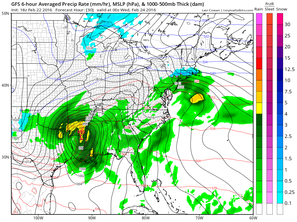
You can see on the GFS map for tomorrow evening that the first system off the Delaware coast is relatively weak compared to the second low that is coming out of Louisiana. That is going to be the major storm as it heads northeast from there. The storm is going to intensify along the way and there will be a large area of the midwest that will get hit with some very heavy snows and near blizzard conditions.
Snow Rain Tuesday Rain Wind Wednesday GFS Wednesday Evening

By Wednesday evening the storm is forecast by the GFS to be in Southwest Ohio and pretty well wrapped up intensity wise. We will be getting strong southerly gales here and there could be some coastal flooding issues along the Long Island South shore as we will be coming off the full moon tonight. Rainfall amounts by the GFS are forecast to be up to 2 inches except higher amounts over Southern New England and Long Island.
Snow Rain Tuesday Rain Wind Wednesday GFS RAINFALL FORECAST

Once this storm goes by weather conditions should begin to improve Thursday morning but Thursday will be a windy day with clouds and some sunshine. Dry air will be with us for Friday and the weekend as the next cold front won’t arrive until early next week and cold air from Canada may have a tough time moving southward based on lastest models.
FiOS1 News Weather Forecast For Long Island
FiOS1 News Weather Forecast For New Jersey
FiOS1 News Weather Forecast For Hudson Valley
NATIONAL WEATHER SERVICE SNOW FORECASTS
LATEST JOESTRADAMUS ON THE LONG RANGE
Weather App

Winter is INSANE! With yet another threat for a major storm don’t be without Meteorologist Joe Cioffi’s weather app. It is really a meteorologist app because you get my forecasts and my analysis and not some automated computer generated forecast based on the GFS model. This is why your app forecast changes every 6 hours. It is model driven with no human input at all. It gives you an icon, a temperature and no insight whatsoever.
It is a complete weather app to suit your forecast needs. All the weather information you need is right on your phone. Android or I-phone, use it to keep track of all the latest weather information and forecasts. This weather app is also free of advertising so you don’t have to worry about security issues with your device. An accurate forecast and no worries that your device is being compromised.
Use it in conjunction with my website and my facebook and twitter and you have complete weather coverage of all the latest weather and the long range outlook. The website has been redone and upgraded. Its easy to use and everything is archived so you can see how well Joe does or doesn’t do when it comes to forecasts and outlooks.
Just click on the google play button or the apple store button on the sidebar for my app which is on My Weather Concierge. Download the app for free. Subscribe to my forecasts on an ad free environment for just 99 cents a month.
Get my forecasts in the palm of your hand for less than the cost of a cup of Joe!
![]()
