
Snow Moving Drying Up
![]()
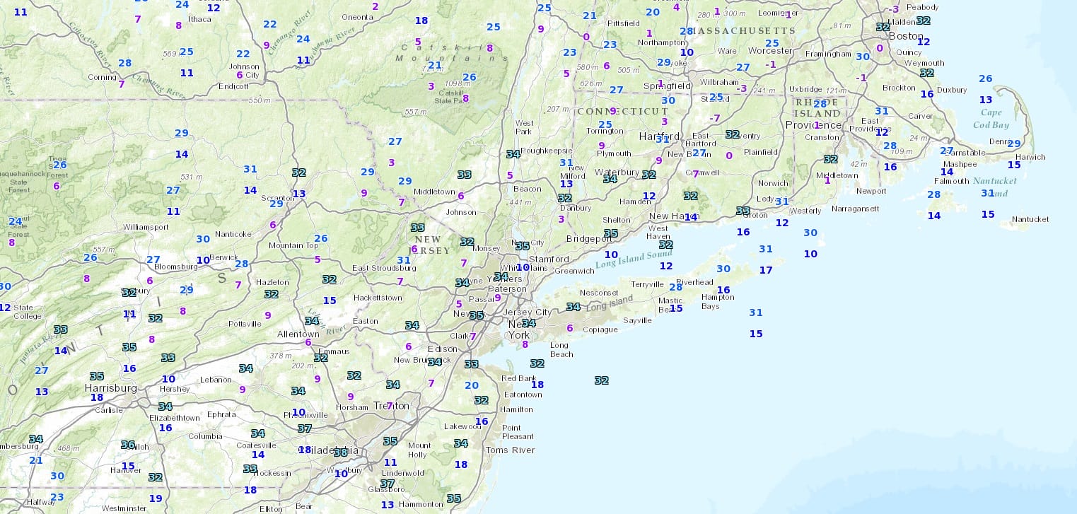
The satellite and radars show the area of snow building up to the south and southwest of us. However there are issues. The biggest issue is the dryness of the air overhead. The temperatures are all cold enough for snow as it is snowing as far south as Virginia at the moment. The problem here is how dry the air is. The temperature map below is from 6pm this evening. The numbers in purple are the dew points. The wider the difference between the temperature and the dew point, the drier the air is. The snow advances into that dry air and just falls apart. Even if the echos on the radar survive, the snow evaporates before it reaches the ground. This is the situation we find ourselves in this evening and for the first part of tonight.
Snow Moving But Drying Up Temperature Dew Point
Radar shows this very well. As the snow advances out of Virginia and moves northward into Southern Pennsylvania it falls apart. You have to look at the radar echos in the green areas to find where precipitation is actually reaching the ground. Now the air will slowly saturate overnight but it won’t be enough to save the initial area of snow. Late tonight Atlantic moisture from the coastal storm begins to get involved. But being on the fringe of the storm, it will be a matter of whether we get into steady snow for a few hours tomorrow morning before the storm pulls away to the northeast.
Snow Moving Drying Up Regional Radar

Local radars at the moment aren’t showing much at the moment but they should get a little busier after midnight as the coastal storm begins to organize along the North Carolina coast.
Snow Moving Drying Up Local Radar Views


Here is the National Weather Service digital snowfall forecast for this event. Notice the snow amounts in general are in the 1 to at most 2 inch range. I really don’t see any reason for this to change. Everything appears to be on course for a minor event. The coastal storm intensifies into a major storm on Friday but it heads out to sea and we dry out Friday afternoon.
Over the weekend Saturday looks dry and cold with sunshine and highs in the upper 30s and lower 40s. Sunday sees another weak disturbance go by with a few rain showers or flurries at worst. Otherwise we will have clouds with highs reaching into the 40s. What follows is a transition to springlike weather next week with some sunshine Monday through Wednesday. Highs will peak on Wednesday as this early forecast high temperature map shows. 70s are probable and I think they will be much further north than what is begin forecast at the moment.
WEDNESDAY HIGH TEMPERATURES SPRINGLIKE 70S!

FiOS1 News Weather Forecast For Long Island
FiOS1 News Weather Forecast For New Jersey
FiOS1 News Weather Forecast For Hudson Valley
NATIONAL WEATHER SERVICE SNOW FORECASTS
LATEST JOESTRADAMUS ON THE LONG RANGE
Weather App

Don’t be without Meteorologist Joe Cioffi’s weather app. It is really a meteorologist app because you get my forecasts and my analysis and not some automated computer generated forecast based on the GFS model. This is why your app forecast changes every 6 hours. It is model driven with no human input at all. It gives you an icon, a temperature and no insight whatsoever.
It is a complete weather app to suit your forecast needs. All the weather information you need is right on your phone. Android or I-phone, use it to keep track of all the latest weather information and forecasts. This weather app is also free of advertising so you don’t have to worry about security issues with your device. An accurate forecast and no worries that your device is being compromised.
Use it in conjunction with my website and my facebook and twitter and you have complete weather coverage of all the latest weather and the long range outlook. The website has been redone and upgraded. Its easy to use and everything is archived so you can see how well Joe does or doesn’t do when it comes to forecasts and outlooks.
Just click on the google play button or the apple store button on the sidebar for my app which is on My Weather Concierge. Download the app for free. Subscribe to my forecasts on an ad free environment for just 99 cents a month.
Get my forecasts in the palm of your hand for less than the cost of a cup of Joe!
![]()
![]()
<


