
DOWNLOAD MY APP FOR FREE & CONSIDER JOINING PATREON

THE APP IS ABSOLUTELY FREE TO ALL BUT CONSIDERING SUBSCRIBING TO PATREON FOR A WEATHER EXPERIENCE FREE OF ADS, EXCLUSIVE VIDEOS FOR MEMBERS ONLY AND MUCH MORE…STARTS AT $2 A MONTH..MESSAGE ME AT ANY TIME
Snow Forecasts National Weather Service Tonight Saturday 3/1/2019
Winter Weather Advisory Northern New Jersey, NYC, Hudson Valley,
Southern New England, Long Island
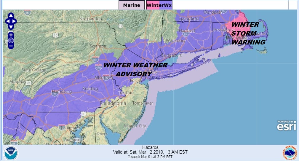
Winter Weather Advisories are now up for tonight into Saturday and below are the National Weather Service snow forecast maps for each area. Be sure to always check time stamps. Most of the maps cover just tonight’s weather system and do not include the next threat which is for late Sunday into Sunday night.
SNOW FORECAST MAPS
New York City, Ne NJ, HV, LI, Coastal Ct
…WINTER WEATHER ADVISORY IN EFFECT FROM 10 PM THIS EVENING TO
NOON EST SATURDAY…
* WHAT…Snow expected. Total snow accumulations of 3 to 5
inches expected.
* WHERE…Southern Connecticut, interior southeast New York, and
northeastern New Jersey mainly along and north of Interstate
80.
* WHEN…From 10 PM this evening to noon EST Saturday.
* ADDITIONAL DETAILS…Plan on slippery road conditions.
…WINTER WEATHER ADVISORY IN EFFECT FROM 7 PM THIS EVENING TO
NOON EST SATURDAY…
* WHAT…Snow and sleet expected. Total accumulations of 2 to 4
inches expected, with the higher amounts expected farther west
and closer to the north shore.
* WHERE…Nassau and Northwestern Suffolk Counties.
* WHEN…From 7 PM this evening to noon EST Saturday.
* ADDITIONAL DETAILS…Plan on slippery road conditions.
..WINTER WEATHER ADVISORY IN EFFECT FROM 7 PM THIS EVENING TO
NOON EST SATURDAY…
* WHAT…Snow and sleet expected. Total snow accumulations of 1 to
3 inches expected, with the higher amounts expected closer to
the north shore.
* WHERE…Southwestern and eastern Suffolk County.
* WHEN…From 7 PM this evening to noon EST Saturday.
* ADDITIONAL DETAILS…Plan on slippery road conditions.
…WINTER WEATHER ADVISORY IN EFFECT FROM 9 PM THIS EVENING TO
7 AM EST SATURDAY…
* WHAT…Mixed precipitation expected. Total snow accumulations of
2 to 4 inches and ice accumulations of a light glaze expected.
* WHERE…Portions of northern and northwest New Jersey and east
central, northeast and southeast Pennsylvania.
* WHEN…From 9 PM this evening to 7 AM EST Saturday.
* ADDITIONAL DETAILS…Plan on slippery road conditions with
reduced visibilities at times Friday night into Saturday
morning..
SOUTHERN NEW ENGLAND

..WINTER WEATHER ADVISORY IN EFFECT FROM 10 PM THIS EVENING TO
NOON EST SATURDAY…
* WHAT…Snow expected. Total snow accumulations of 3 to 5
inches expected.
* WHERE…Southern Connecticut, interior southeast New York, and
northeastern New Jersey mainly along and north of Interstate
80.
* WHEN…From 10 PM this evening to noon EST Saturday.
* ADDITIONAL DETAILS…Plan on slippery road conditions.
NEW JERSEY & PARTS OF NE PA

..WINTER WEATHER ADVISORY IN EFFECT FROM 9 PM THIS EVENING TO
7 AM EST SATURDAY…
* WHAT…Mixed precipitation expected. Total snow accumulations of
2 to 4 inches and ice accumulations of a light glaze expected.
* WHERE…Portions of northern and northwest New Jersey and east
central, northeast and southeast Pennsylvania.
* WHEN…From 9 PM this evening to 7 AM EST Saturday.
* ADDITIONAL DETAILS…Plan on slippery road conditions with
reduced visibilities at times Friday night into Saturday
morning..
CENTRAL & SOUTH CENTRAL PA

..WINTER WEATHER ADVISORY REMAINS IN EFFECT FROM 8 PM THIS
EVENING TO 7 AM EST SATURDAY…
…WINTER STORM WATCH IN EFFECT FROM SUNDAY MORNING THROUGH
MONDAY MORNING…
* WHAT…Mixed precipitation expected. Heavy snow possible. Total
snow accumulations of 1 to 3 inches topped by a light glazing of
ice are expected tonight. Additional snow accumulations of 4 to
6 inches are possible Sunday and Sunday night.
* WHERE…Portions of central Pennsylvania.
* WHEN…For the Winter Weather Advisory, from 8 PM this evening
to 7 AM EST Saturday. For the Winter Storm Watch, from Sunday
morning through Monday morning.
* ADDITIONAL DETAILS…Plan on slippery road conditions. Be
prepared for reduced visibilities at times.
Please be advised that these are National Weather Service Forecast Maps and they auto update. Each office may update at different times and some offices are slower to update then others. Maps are usually updated before 5am and & 5pm however they may be updated at other times depending on forecast conditions. These are not my forecasts. My forecasts can be found on the JOE’S SNOWFORECAST PAGE. Individual forecasts for specific areas may also be found when conditions warrant on the my area forecasts. Those can be found on the website menu. Click on forecasts and then select your specific area.