Snow Forecasts Monday April 2 2018 National Weather Service
Snow Forecasts Monday April 2 2018 National Weather Service

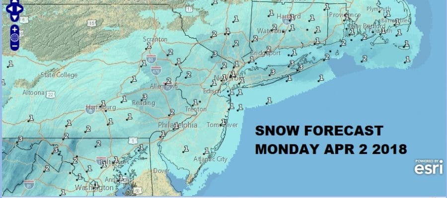
I thought by now we would be done with this but we have a cold front moving through tonight that will be stalling out and a wave of low pressure moving along it. This is a very fast moving system with snow coming in during the early morning hours on Monday and done probably by mid morning. Temperatures will be close to freezing away from urban areas so what falls at night likely will stick to cold surfaces and even on roadways. Once we get past sunrise and the sun angle takes over we probably won’t see snow stick to much more. This looks like a 1 to 3 inch event in most places with some 4 inch amounts possible in some places. Some models have gone a little more bullish with snow amounts overnight but I will wait until the day cycle model runs and evaluate. There are no weather issues today and Sunday. A cold front coming through tonight triggers off a rain or snow shower before daybreak but nothing more than that.

GET JOE A CIGAR SO HE CAN RELAX!
NEW YORK CITY AND VICINITY SNOW

NEW JERSEY & PARTS OF NE PA

SOUTHERN AND SOUTHEAST NEW ENGLAND

NORTHERN NEW ENGLAND

WESTERN NEW ENGLAND

MIDDLE AND UPPER HUDSON VALLEY

CENTRAL NEW YORK & NE PA

WESTERN NEW YORK

CENTRAL & SOUTH CENTRAL PA

VIRGINIA & MARYLAND

DAILY NORTHEAST SNOWFALL

Please be advised that these are National Weather Service Forecast Maps and they auto update. Each office may update at different times and some offices are slower to update then others. Maps are usually updated before 5am and & 5pm however they may be updated at other times depending on forecast conditions. These are not my forecasts. My forecasts can be found on the JOE’S SNOWFORECAST PAGE. Individual forecasts for specific areas may also be found when conditions warrant on the my area forecasts. Those can be found on the website menu. Click on forecasts and then select your specific area.


