
Snow Forecast Maps Updated Wednesday 03072018
Snow Forecast Maps Updated Wednesday 03072018
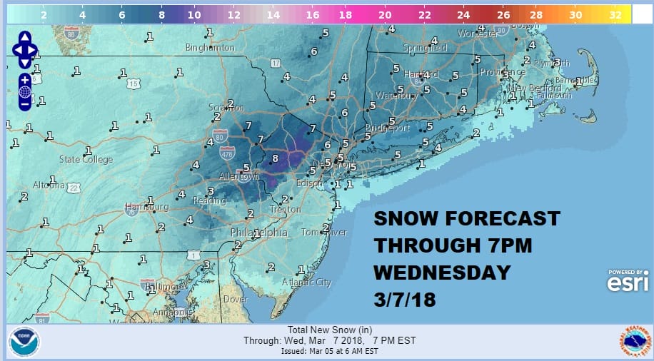
The map above is an early National Weather Service call for snow and it only goes through 7pm Wednesday so there will be additional snow to follow in areas from NYC and Northern New Jersey north and east. Meantime we do have winter storm watches that have been issued from Central New Jersey (north and east of the NJ Turnpike) and neighboring Eastern & Northeastern Pennsylvania to New England including NYC, Long Island and everyone else in between. The usual issues are there regarding the coast and a change to rain. Colder models are going to be favored here given the upper air conditions and a more coastal track is being indicated by some. There is much to resolve here but I think the early calls by the Weather Service are generally fair. We will be absorbing more information as the day wears on and we will be coming out with our forecast later today.

GET JOE A CIGAR SO HE CAN RELAX!
NEW YORK CITY AND VICINITY SNOW

NEW JERSEY & PARTS OF NE PA

SOUTHERN AND SOUTHEAST NEW ENGLAND

NORTHERN NEW ENGLAND

WESTERN NEW ENGLAND

MIDDLE AND UPPER HUDSON VALLEY

CENTRAL NEW YORK & NE PA

WESTERN NEW YORK

CENTRAL & SOUTH CENTRAL PA

VIRGINIA & MARYLAND

DAILY NORTHEAST SNOWFALL

Please be advised that these are National Weather Service Forecast Maps and they auto update. Each office may update at different times and some offices are slower to update then others. Maps are usually updated before 5am and & 5pm however they may be updated at other times depending on forecast conditions. These are not my forecasts. My forecasts can be found on the JOE’S SNOWFORECAST PAGE. Individual forecasts for specific areas may also be found when conditions warrant on the my area forecasts. Those can be found on the website menu. Click on forecasts and then select your specific area.