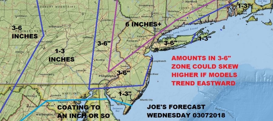
Noreaster Part 2 Joe’s Snow Forecast Map 03072018
Noreaster Part 2 Joe’s Snow Forecast Map 03072018
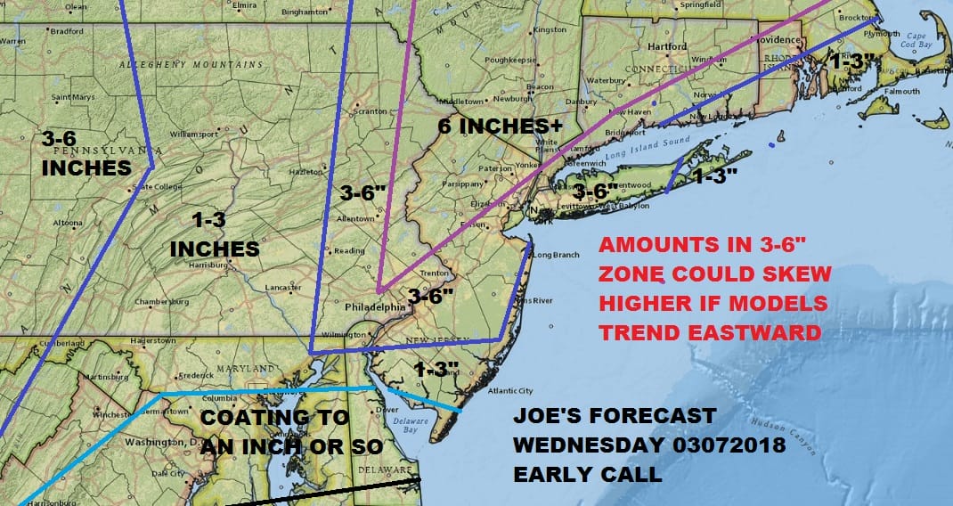
I’m taking a cautious view on this but I think that the greatest risk at this point is that coastal amounts could skew higher. We are dealing with a much colder atmosphere here than what we had last Friday and I think this is an important difference. The NAM is typically warmer in situations like this. The model has the hot hand but usually at the point where everyone figures this out, it stops working. The European model is very cold in the lower atmosphere and it keeps temperatures below freezing at critical levels of the atmosphere in all areas including the coast. The surface low mores more east northeast to the benchmark 40N 70W then the others. The Canadian comes close to the European’s view. Even the GFS and NAM to a certain extent show it colder. This will be during the day Wednesday and for areas in and around NYC north and east the bulk of the snow will come later in the day Wednesday into Wednesday night while areas to the south will see it a bit earlier. We still have quite a few model runs to go here but I’m strongly leaning to a colder, snowier and more offshore solution. If this is the case look for these numbers to go higher in most areas. In fact a colder solution could result in the higher numbers being flipped to the coast with the lower numbers north and west.
The satellite loop shows the coastal storm from Friday still sitting in the Western Atlantic northeast of Bermuda. It remains trapped there under the blocking high to the north in Eastern Canada. The clouds from the storm system from the Northern Plains extend to the Western Lakes and Southward into the Gulf States where the secondary low is likely to come from once that energy heads into the Southeast US. Skies here have been fighting clouds all day and we should see some clearing tonight with lows in the mid 20s to lower 30s. Tuesday we should see some sunshine before clouds increase with highs reaching into the 40s.
US SATELLITE

REGIONAL RADAR

Snow will develop Southeastern Pennsylvania and Southern New Jersey Tuesday night into early Wednesday and then spread northward to NYC and Southern New England by Wednesday midday or early afternoon. The secondary low should take over from the parent low in the Ohio Valley Wednesday morning near the North Carolina coast and then head northeast toward the 40N 70W bench mark after an initial northward push to off the Delaware coast. Snow continues into Wednesday night. Along coastal areas of New Jersey and Long Island a mixing or rain issue remains on the table at least for now.
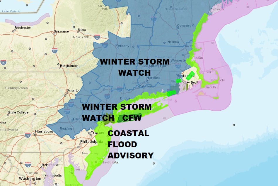
Winds will become strong and gusty but I think the strongest winds this time will cover a smaller geographic area near the coast. Coastal flooding remains an issue at high tides until further notice. Compared to Friday’s storm this will be formidable but not as imposing as Friday’s noreaster.
 GET JOE A CIGAR IF YOU LIKE

FiOS1 News Weather Forecast For Long Island
FiOS1 News Weather Forecast For New Jersey
FiOS1 News Weather Forecast For Hudson Valley


