Snow Ending Colder Thursday Friday Weekend
Snow Ending Colder Thursday Friday Weekend
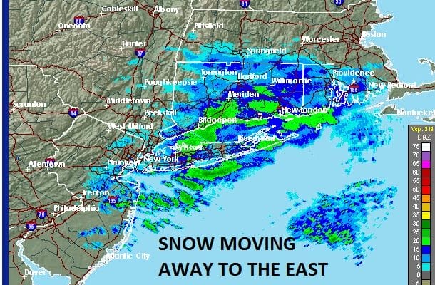
Latest radars and satellite loops show the bulk of the snow is moving out to the east and what is in Western Pennsylvania at the moment will probably dry up and reform to the north and east of us tonight so for the most part this snow event is ending. There is still some snow at the moment over Long Island and Connecticut but that should be coming to an end in the next few hours. Most areas received anywhere from a coating to a couple of inches. Now we being the transition to a colder air mass for the end of the week and the weekend.
SATELLITE LOOP

REGIONAL RADAR

LOCAL RADAR NEW YORK CITY

LOCAL RADAR PHILADELPHIA


Tonight temperatures will be near or below freezing so this could create some icing in some areas so be careful if travelling around. Wednesday looks to be mild as a cold front passes through with nothing more than clouds and a passing rain or snow shower with temperatures in the 40s. Colder air arrives Wednesday night. Thursday through Saturday will be quite cold with some sunshine and highs just in the lower 30s on average and lows in the teens to low 20s. There could be some snow showers around on Thursday but nothing significant. Sunday we will be watching an approaching cold front, It appears now with the absence of any system from the south, that this will be a relatively weak system when it comes through with some rain or snow shower. We will discuss this matter further later this evening.
SNOW REMOVAL COMPANIES FOR YOUR WINTER NEEDS
LONG ISLAND ROCKLAND COUNTY Connecticut

![]()

ROCKLAND COUNTY TRI STATE SNOW REMOVAL JOHNSTOWN PA


FiOS1 News Weather Forecast For Long Island
FiOS1 News Weather Forecast For New Jersey
FiOS1 News Weather Forecast For Hudson Valley
NATIONAL WEATHER SERVICE SNOW FORECASTS
LATEST JOESTRADAMUS ON THE LONG RANGE
Weather App

Don’t be without Meteorologist Joe Cioffi’s weather app. It is really a meteorologist app because you get my forecasts and my analysis and not some automated computer generated forecast based on the GFS model. This is why your app forecast changes every 6 hours. It is model driven with no human input at all. It gives you an icon, a temperature and no insight whatsoever.
It is a complete weather app to suit your forecast needs. All the weather information you need is right on your phone. Android or I-phone, use it to keep track of all the latest weather information and forecasts. This weather app is also free of advertising so you don’t have to worry about security issues with your device. An accurate forecast and no worries that your device is being compromised.
Use it in conjunction with my website and my facebook and twitter and you have complete weather coverage of all the latest weather and the long range outlook. The website has been redone and upgraded. Its easy to use and everything is archived so you can see how well Joe does or doesn’t do when it comes to forecasts and outlooks.
Just click on the google play button or the apple store button on the sidebar for my app which is on My Weather Concierge. Download the app for free. Subscribe to my forecasts on an ad free environment for just 99 cents a month.
Get my forecasts in the palm of your hand for less than the cost of a cup of Joe!


