
Slow Warmup Continues Rain For New Year Arrival
Warm Pattern Continues Into Next Week
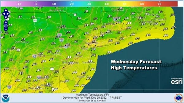
The warm up from the arctic air mass of the weekend continues and for the first time since last Thursday we will be in the 40s. That is going to feel so warm that you may be tempted to go coatless! We are seeing high clouds moving across areas to the north in Upstate NY and New England but we should have a fair amount of sunshine today and most highs will fall in a range of 40 to 45. Light snows are on the regional radar well northin upstate NY and New England as a warm front sets up north of us. Local radars are nice and quiet and will remain so through Friday.
SATELLITE

WEATHER RADAR

As we move along the nights will be getting warmer with lows tonight in the 20s to around 30 with the coldest spots down in the upper teens. Thursday and Friday will be warmer with no weather issues to speak of. Both days will feature sunshine. Highs Thursday will be in the upper 40s to around 50 and Friday highs will reach the 50s everywhere.
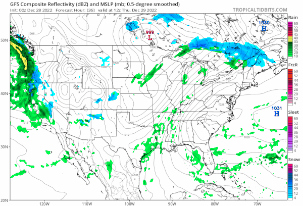
Over the weekend we will see some rain but we may get lucky for New Year’s Eve celebrations in that the rain comes in during the day Saturday and that there will only be some scattered showers and that “magical” moment at midnight when the calendar turns. Temperatures will be warm with Saturday highs in the 50s to near 60. There will still be some showers around Sunday, otherwise skies will be mainly cloudy with most highs in the upper 50s and lower 60s. No major storms are on the horizon for the next week to 10 days at least.
BE SURE TO DOWNLOAD THE FREE METEOROLOGIST JOE CIOFFI WEATHER APP &
ANGRY BEN’S FREE WEATHER APP “THE ANGRY WEATHERMAN!
MANY THANKS TO TROPICAL TIDBITS & F5 WEATHER FOR THE USE OF MAPS
Please note that with regards to any severe weather, tropical storms, or hurricanes, should a storm be threatening, please consult your local National Weather Service office or your local government officials about what action you should be taking to protect life and property.


