
Warm into Next Week Rain New Year’s Eve Mostly Dry New Year’s Day

The rise in temperatures continues today. Usually this time of year if it is going to be warm it will also be raining. This is not the case today and Friday. We are seeing lots of sunshine today with nothing more than some passing high clouds thanks to a warm front to our north. Arctic air is gone and temperatures should respond nicely with highs reaching the upper 40s to lower 60s. There are no issues on the radar and there shouldn’t be until Saturday
SATELLITE

WEATHER RADAR

Tonight won’t be particularly cold at all with most lows in the upper 20s to mid 30s. Friday looks to be a nice sunny day with a mostly west wind. We should see highs reach the low and middle 50s just about everywhere.
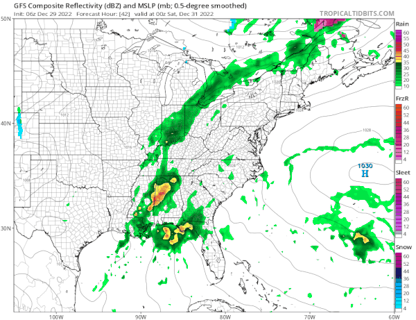
Low pressure from the Central Gulf States will head to the Great Lakes Saturday and move across the Northeast Sunday. There is no cold air air around anywhere so it will be a rain event. The timing of the rain looks to be arriving from south to north Saturday afternoon and it may be mostly done around midnight or so as the New Year arrives. It will last a little longer in Southeastern New England and linger into Sunday morning.
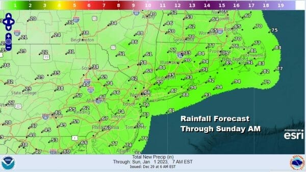
Rainfall amounts won’t be too problematic with amounts mostly in a range of 1/2 to 3/4 inch. New Year’s Day will be a day that starts with clouds but perhaps there could be some improvement as the day wears on. Highs Saturday will be in the 50s and Sunday highs will be in the 50s to around 60. Next week will start warm and there will be another cold front with a threat for rain midweek. After that we will see temperatures turn colder at least trending down closer to average for this time of year.
BE SURE TO DOWNLOAD THE FREE METEOROLOGIST JOE CIOFFI WEATHER APP &
ANGRY BEN’S FREE WEATHER APP “THE ANGRY WEATHERMAN!
MANY THANKS TO TROPICAL TIDBITS & F5 WEATHER FOR THE USE OF MAPS
Please note that with regards to any severe weather, tropical storms, or hurricanes, should a storm be threatening, please consult your local National Weather Service office or your local government officials about what action you should be taking to protect life and property.


