Slow Warm Up Today Saturday Rain Chance Sunday Into Monday
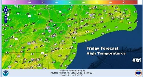
We have arrived at Friday and looking ahead to the weekend. We are seeing this morning on the satellite that the upper trough to the northwest that has been there all week is pulling away to the northeast in Eastern Canada and we have a wave of low pressure to the east that is moving away and that leaves us in a nice sweet spot today. We will have lots of sunshine and the southwest wind should finally start to bring temperatures higher this afternoon with highs reaching into the lower 60s in most places. Radars are nice and quiet and rain is not an issue today or through Saturday.
SATELLITE

WEATHER RADAR

Multilple nights of frosts and freezes comes to an end tonight with lows in the mid 30s in the coldest spots and maybe some frost well inland but elsewhere lows will be in the 40s and warmer urban centers will probably bottom around or just over 50.
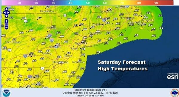
High pressure build in New England and then pulls away to the east near and south of Nova Scotia with a protective arm back to the coast. This leaves us with a very nice Saturday of sunshine. Highs will reach the middle to upper 60s and one or two spots might even tough the 70 degree mark. The high is holding back low pressure that forms off the Southeast US coast however it will not be able to hold it off for long.
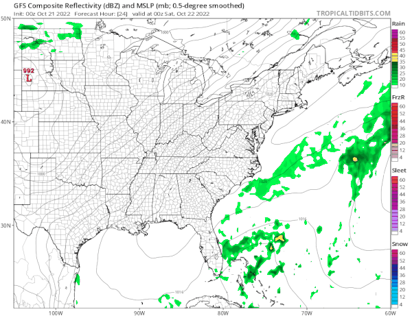
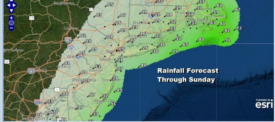
Saturday night into Sunday the low moves up the coast and with it an area of rain. How far west the rain shield gets remains a question here as models are all over the place with the rain shield. I’m thinking that the western edge of the rain shield makes to about the NJ/PA border with a steadier heavier rain east of NYC to Long Island as well as Southern and Southeastern New England. Sunday highs will be just into the 60s thanks to clouds and the potential for some rain.

Rainfall amounts are on the light side from NYC west where amounts are less than a quarter inch while to the east the amounts go up. This map is for rain through 8pm Sunday so it won’t include any rain that occurs Sunday night into Monday morning with some lingering showers. We should see some improvement for the first half of next week before the next cold front with another coastal low brings the chance for rain late week.
BE SURE TO DOWNLOAD THE FREE METEOROLOGIST JOE CIOFFI WEATHER APP &
ANGRY BEN’S FREE WEATHER APP “THE ANGRY WEATHERMAN!
MANY THANKS TO TROPICAL TIDBITS & F5 WEATHER FOR THE USE OF MAPS
Please note that with regards to any severe weather, tropical storms, or hurricanes, should a storm be threatening, please consult your local National Weather Service office or your local government officials about what action you should be taking to protect life and property.


