
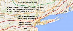
Sleet Freezing Rain Arrives Tonight
Sleet freezing rain is the primary issue tonight as it arrives between 7pm and 11pm from west to east across the area. Winter Weather Advisory is posted now for all inland areas in Northern New Jersey, Northeastern Pennsylvania, Southeast New York (except New York City & Long Island) and virtually all of Connecticut execpt the extreme southeast part of the state.
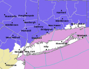
My snow/ice forecast issued 3 days ago remains unchanged. The borderline cold air has pretty much remained that way with the coldest air well north and northeast. Along the coast I expect no difficulties. Inland temperatures will be close to or just below freezing. The good news is that most tempertures during today will remain above freezing which is an advantage. It is not as if we are spending the day in the 20s so this makes this less problematic. However inland tonight with temperatures getting below 32 for awhile there will be some icing issues to consider. I do not expect to make any major changes to this map given the situation we are in. Sleet freezing rain is the primary issue tonight and snow will be at a minimum in this event as the atmosphere aloft is just not cold enough.
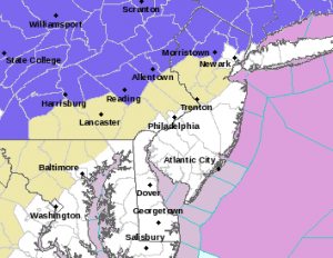
This morning we are seeing precipitation spreading rapidly eastward across the Midwest and the Ohio Valley and it should be arriving in Northeast Pennsylvania very late this afternoon and early evening and then elsewhere between 8pm and midnight. Here are some snow and ice accumulation maps through Tuesday morning when by daybreak it should be mostly rain except in far northern areas north of route 84.

Latest satellite loop shows the well defined swirl of the storm in the southwest moving out of Texas and heading northeast toward the Southern Great Lakes. Weather conditions will improve in Texas after a weekend of devestating severe weather ranging from tornadoes in Dallas to blizzard conditions in western parts of that state.


NATIONAL WEATHER SERVICE SNOW FORECASTS
LATEST JOESTRADAMUS ON THE LONG RANGE
Weather App

Winter is coming. Don’t be without Meteorologist Joe Cioffi’s weather app. It is a complete weather app to suit your forecast needs. All the weather information you need is right on your phone. Android or I-phone, use it to keep track of all the latest weather information and forecasts. This weather app is also free of advertising so you don’t have to worry about security issues with your device. An accurate forecast and no worries that your device is being compromised.
Use it in conjunction with my website and my facebook and twitterand you have complete weather coverage of all the latest weather and the long range outlook. The website has been redone and upgraded. Its easy to use and everything is archived so you can see how well Joe does or doesn’t do when it comes to forecasts and outlooks.
Just click on the google play button or the apple store button on the sidebar for my app which is onMy Weather Concierge. Download the app for free. Subscribe to my forecasts on an ad free environment for just 99 cents a month.
Get my forecasts in the palm of your hand for less than the cost of a cup of Joe!

![]()


