Showery Rains Possible Today Cold Front Brings Showers Sunday Night
Week Ahead Cooler

Showery Rains Possible Today Cold Front Brings Showers Sunday Night
Week Ahead Cooler
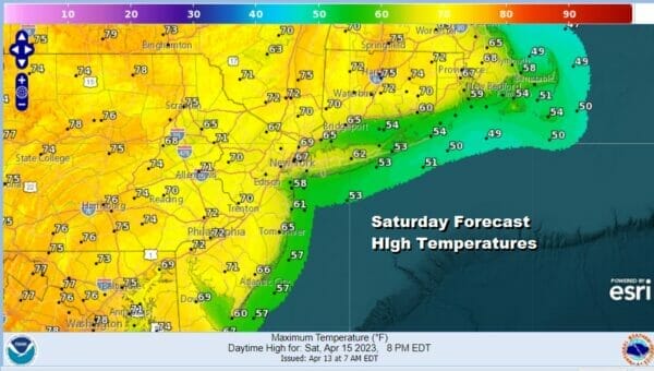
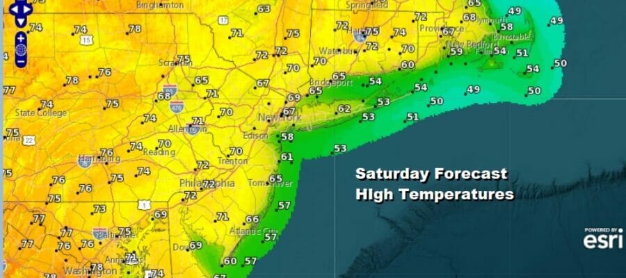
This is going to be a day of changes across the area. Though no cold front has passed, and we have a launching pad of rather high morning lows, there will be no record highs today and no highs in the 80s and 90s. The high to the southwest the last two days which created a west wind here, is now offshore and that has allowed the wind to become southerly off the ocean. We also have on the satellite loop and radar a lot of clouds and some showery rains and they are moving northward. All these factors should leave us with temperatures in the 60s along the coast and low to middle 70s inland for highs this afternoon. Showery rains will be around but not all day and some folks may see little or nothing but the risk is there depending on how they set up on the radar.
SATELLITE

WEATHER RADAR

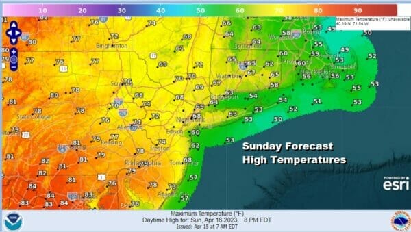
Dew points will be rising today into Sunday so look for temperatuers to remain in the 50s overnight with clouds and perhaps some leftover showers. Sunday overall should be a day with not much in the way of rain though the odd shower can’t be ruled out. A warm front is going to set up across the area from northwest to southeast so depending on which side of it you are on you will be either in the 60s northeast of NYC into New England or in the upper 70s and lower 80s from Southern New Jersey and Southern Pennsylvania southward. Clouds will be around to the northeast with a better chance for some sun as you go southwest.
A cold front out of a storm developing in the Plains and heading to the Great Lakes will move eastward Sunday spreading showers and thunderstorms across Ohio and Western Pennsylvania but these showers and possible thunderstorms won’t arrive until sometime Sunday night so the daytime Sunday should be okay. We do not anticipate any severe weather from this front as it passes.

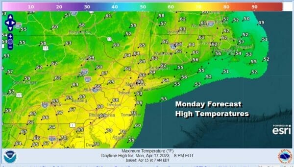
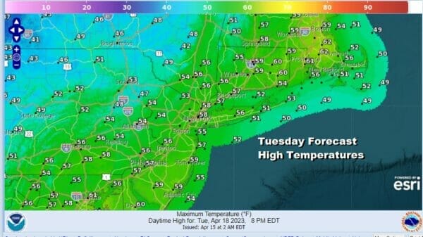
These showers should be gone by daybreak Monday and then we will have leftover clouds and some sunshine developing with highs in the 60s. A cooler pattern develops for the start of next week and it will be a mostly dry one. Tuesday will be in sharp contrast to yesterday as highs Tuesday with sunshine will be mostly in the 50s.
Most of next week should be dry. Temperatures should bounce higher into the 60s Wednesday and back into the 70s Thursday. Weak weather systems will be moving through late next week and while most of the time it will be dry, expect an interruption or two with some showers from time to time Thursday into next weekend.

As far as rainfall amounts are concerned with today’s showery rains and the Sunday night cold front, amounts will range from a quarter to a half inch in most places with higher amounts as you go west and northwest into Upstate NY and Pennsylvania.
BE SURE TO DOWNLOAD THE FREE METEOROLOGIST JOE CIOFFI WEATHER APP &
ANGRY BEN’S FREE WEATHER APP “THE ANGRY WEATHERMAN!
MANY THANKS TO TROPICAL TIDBITS & F5 WEATHER FOR THE USE OF MAPS
Please note that with regards to any severe weather, tropical storms, or hurricanes, should a storm be threatening, please consult your local National Weather Service office or your local government officials about what action you should be taking to protect life and property.


