
Showers Thunderstorms Severe Weather Risk Monday As Cold Front Arrives

After yesterday’s dramatic temperature fall from the 80s to the 40s in just a matter of a couple of hours (in some areas) things are a little more settled today. The cold front has settled itself over Delaware and Maryland and it will start to move back northward later today. We have clouds to the north of the frontal boundary and a mix of sun and clouds to the south. East winds are to the north of the front and southwest winds to the south. This creates a wide spread in highs today which will range from the 40s and 50s over Long Island Connecticut & the northern half of New Jersey to the 70s South Jersey & Southern Pennsylvania southward into Maryland and Virginia.
SATELLITE WITH LIGHTNING STRIKES

WEATHER RADAR

As far as precipitation is concerned today, it should spotty and light, if at all. The higher chances will be close to the coast during the day and some inland areas overnight as the warm front goes by. This is going to set much of the area up for thunderstorms and severe weather risk Monday afternoon and evening as a strong cold front in the Midwest and Deep South today and tonight reaches the East Coast Monday.

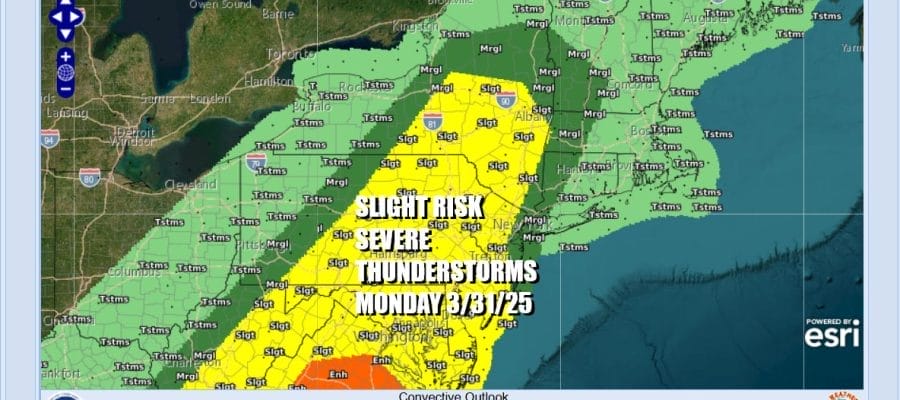
The front is going to move through the Appalachians and reach the coast Monday evening. The warm front to our south will push back into Upstate NY and hairpin southward to Long Island and will create a warm sector to the west. The Storm Prediction Center is indicating a slight risk for severe thunderstorms Monday afternoon and evening in much of Maryland, Delaware, Pennsylvania, New Jersey and Upstate NY.

The marginal risk for isolated severe thunderstorms extends just to the east and northeast of New York City to Western Long Island and Western Connecticut. This is due to the warm front getting pinched along the coast and leaving cooler marine area trapped in much of Southern & Southeastern New England. High temperatures Monday will be in the 70s inland with 50s and 60s to the east.
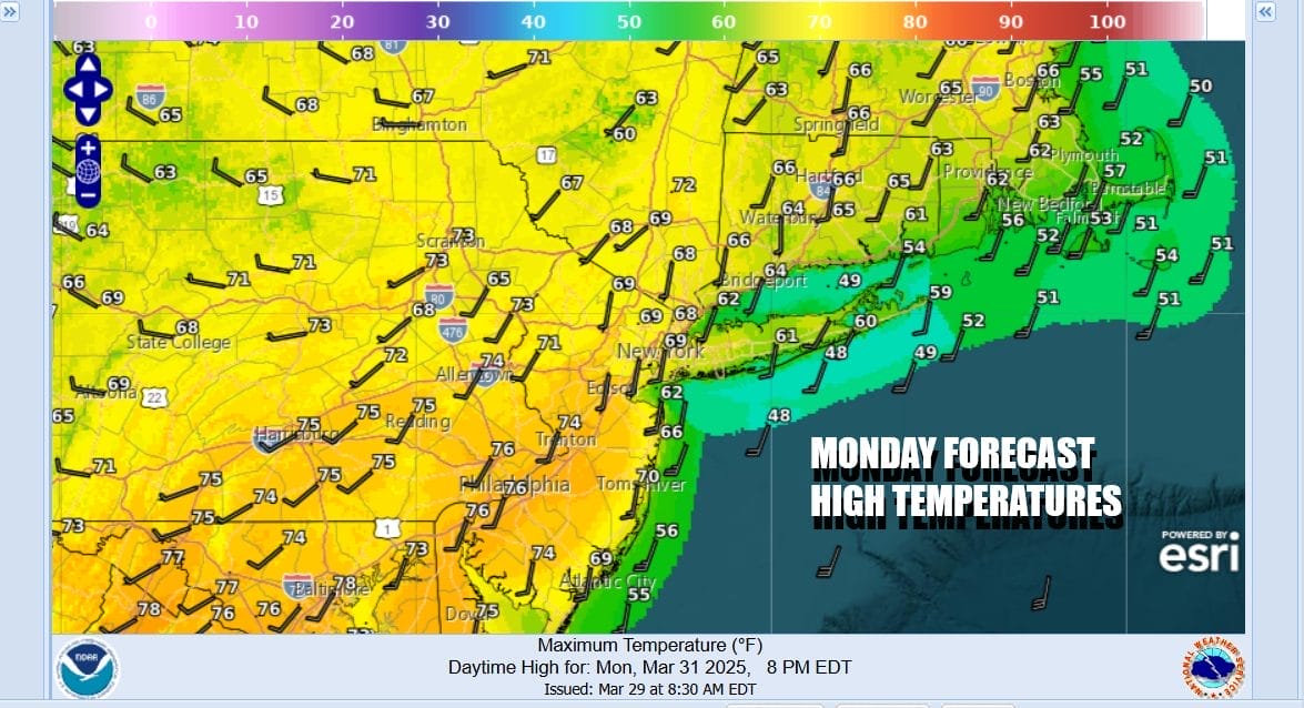
Scattered showers will be around Monday with more numerous showers and thunderstorms developing from west to east in the afternoon and evening. Weather conditions once the front moves offshore later Monday night so we should see returning sunshine and colder temperatures area wide Tuesday. Most highs will be just into the low and middle 50s.
BE SURE TO DOWNLOAD THE FREE METEOROLOGIST JOE CIOFFI WEATHER APP &
ANGRY BEN’S FREE WEATHER APP “THE ANGRY WEATHERMAN!
MANY THANKS TO TROPICAL TIDBITS FOR THE USE OF MAPS
Please note that with regards to any severe weather, tropical storms, or hurricanes, should a storm be threatening, please consult your local National Weather Service office or your local government officials about what action you should be taking to protect life and property.


