
Showers Stay West All Week Long Warm Quiet Conditions Continue
JOE & JOE WEATHER SHOW MONDAY OCTOBER 19, 2020
WEATHER IN 5 MONDAY OCTOBER 19, 2020
The main issue this week is two fold. First is a warm frontal boundary to the west that is stalled out from Western NY southwestward into the Ohio and Mississippi Valleys. Second is high pressure offshore at the surface and aloft that won’t be giving way much this week. The result is showers that will be in Western Pennsylvania and Western NY might creep as far east as the Western Catskills and Poconos but they should stay mainly west of I-81. Along the coast nighttime and early morning low clouds and some patchy fog may be possible especially later this week as the air mass gets a bit stagnant and winds occasionally turn from the south to the southeast.
SATELLITE

REGIONAL RADAR

Regional radar shows showers to the northwest as a wave of low pressure heads into Northern New England. The leading edge of the rain is showing up on the local radars below but they should fall apart as they lose support in our rather stable air mass.
LOCAL RADAR NEW YORK CITY

LOCAL RADAR PHILADELPHIA


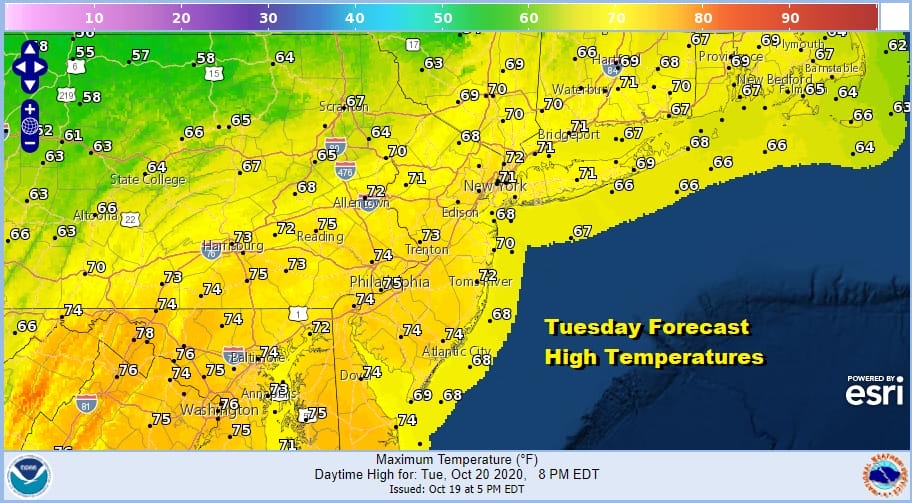
Tonight should be a quiet autumn night with some low clouds and maybe even a little patchy fog or some drizzle possible in scattered places. Most lows will be in the 50s to around 60. Tuesday clouds should give way to some breaks of sun but another wave goes by well north and west and that could mean some cloud cover around. Highs will reach the low and middle 70s in most places.
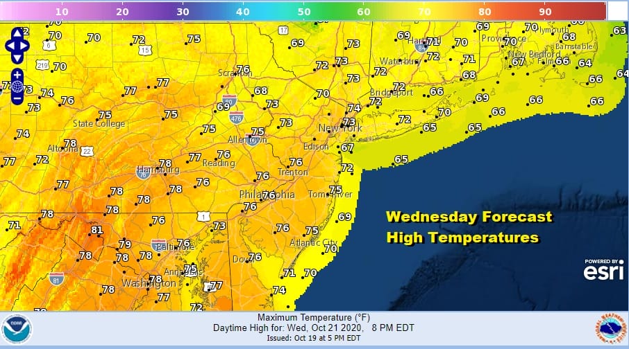
Wash rinse repeat for Wednesday as another wave goes by to our north. The only question in my mind is cloud cover and how much. That will impact temperatures. Low to mid 70s should also be the story for Wednesday.
On and on it goes for Thursday and Friday with a mix of clouds and sun both days with highs in the low to mid 70s inland and cooler along the coast with onshore winds from time to time. Saturday brings a weak cold front through as the day passes but there won’t be much with it other than clouds and perhaps a scattered shower with highs in the upper 60s to lower 70s.

Tropical Storm Epsilon is the primary driver of our weather pattern is it is holding everything up until it makes the turn north and northeastward, which it eventually does later in the weekend. Perhaps there could be a close pass to Bermuda. Once it turns to the northeast and moves away the traffic jam over the US will break down and weather systems will being to move again. Sunday will be cooler with northeast winds as a high builds across the Northern Great Lakes and Southeastern Canada. We favor it being dry even though a front will be stalled nearby. The GFS model has a wetter look to it but we will hold out for a day or two before committing to any showers. Then next week a front of greater strength should make its way east with some widespread showers possible later Monday or Tuesday.
BE SURE TO DOWNLOAD THE FREE METEOROLOGIST JOE CIOFFI WEATHER APP &
ANGRY BEN’S FREE WEATHER APP “THE ANGRY WEATHERMAN!
MANY THANKS TO TROPICAL TIDBITS FOR THE USE OF MAPS
Please note that with regards to any severe weather, tropical storms, or hurricanes, should a storm be threatening, please consult your local National Weather Service office or your local government officials about what action you should be taking to protect life and property.


