Showers Moving East North of NYC
Showers Moving East North of NYC
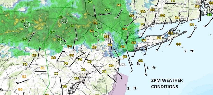
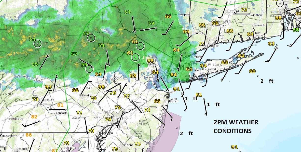
Looking at the satellite and radar loops below showers seem to be lining up along and north of route 78 to about NYC into Western Long Island northward. The area of showers moving east does not have any imbedded thuderstorms at the moment and most of the rain appears to be on the light side. South of Route 78 into Central and Southern New Jersey
SATELLITE

REGIONAL RADAR

LOCAL RADAR NEW YORK CITY

LOCAL RADAR PHILADELPHIA


It is a fine line that exists right now along Route 78 across New Jersey and Eastern Pennsylvania but it should hold up for the rest of the day. Temperatures are in the 70s south of Route 78 thanks to some sun and it could still hit 80 in a few spots. North of there with the onshore wind developing temperatures seem to have settled in the 60s. Showers should spread southeastward overnight however as low pressure begins to develop to our south.
Monday and Tuesday have become tricky with various models showing rain at different times of the day and night and in different areas. When weather models are like this the only thing to do is indicate that there is the chance for rain both Monday through Tuesday and that some areas will get some and some won’t. Depending on this stubborn upper air storm in the east there will be cloud issue lingering into Wednesday and Thursday with a diminished shower threat. Temperatures the next 2 days will probably be in the 60s at best most of the time.
 GET JOE A CIGAR IF YOU LIKE

LANDSCAPE COMPANIES FOR YOUR NEEDS
LONG ISLAND ROCKLAND COUNTY Connecticut

![]()

ROCKLAND COUNTY TRI STATE SNOW REMOVAL JOHNSTOWN PA


FiOS1 News Weather Forecast For Long Island
FiOS1 News Weather Forecast For New Jersey
FiOS1 News Weather Forecast For Hudson Valley
NATIONAL WEATHER SERVICE SNOW FORECASTS
LATEST JOESTRADAMUS ON THE LONG RANGE
Weather App

Don’t be without Meteorologist Joe Cioffi’s weather app. It is really a meteorologist app because you get my forecasts and my analysis and not some automated computer generated forecast based on the GFS model. This is why your app forecast changes every 6 hours. It is model driven with no human input at all. It gives you an icon, a temperature and no insight whatsoever.
It is a complete weather app to suit your forecast needs. All the weather information you need is right on your phone. Android or I-phone, use it to keep track of all the latest weather information and forecasts. This weather app is also free of advertising so you don’t have to worry about security issues with your device. An accurate forecast and no worries that your device is being compromised.
Use it in conjunction with my website and my facebook and twitter and you have complete weather coverage of all the latest weather and the long range outlook. The website has been redone and upgraded. Its easy to use and everything is archived so you can see how well Joe does or doesn’t do when it comes to forecasts and outlooks.
Just click on the google play button or the apple store button on the sidebar for my app which is on My Weather Concierge. Download the app for free. Subscribe to my forecasts on an ad free environment for just 99 cents a month.
Get my forecasts in the palm of your hand for less than the cost of a cup of Joe!


