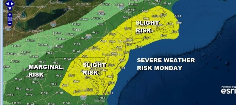
Severe Weather Risks Heatwave Ends Today As Cold Front Passes

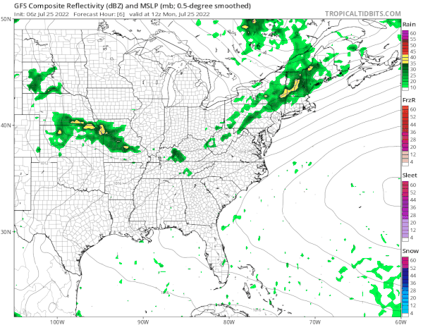
Yesterday was the hottest day of the heatwave with highs reaching 100 degrees in many locations. Today is the last day of the heatwave and the streak will end at 7 days of 90 degrees plus. The heatwave will be broken by a cold front that is moving across Pennsylvania and is producing showers and thunderstorms. Expect those storms to get here this afternoon and into this evening from west to east. The Storm Prediction Center has a slight risk for severe weather today in a large area from Virginia to Maine and it includes all the major cities from Washington DC to Boston.
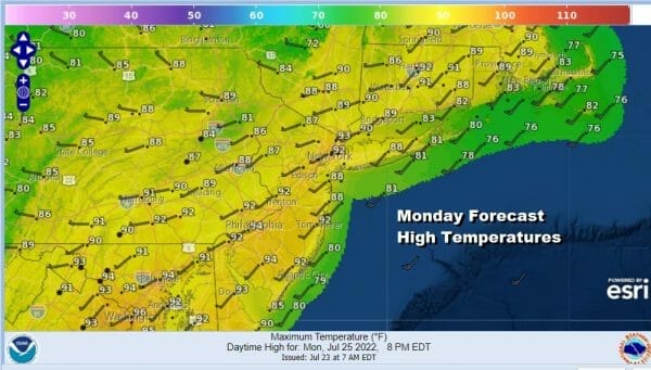
We have more clouds around than we have seen in days and that is going to cut down on the daytime heating. A launching pad of 70s to near 80 in the morning would normally take us to the mid to upper 90s. However between the clouds and the arriving front, highs this afternoon will be in the upper 80s to lower 90s. Thunderstorms will pass through and the greatest risk will be from strong winds and downdrafts from some of the stronger thunderstorms. There is a 2 percent risk of tornadoes from Northern New Jersey to New England.
SATELLITE

WEATHER RADAR

Once the front passes we will start to cool off and more importantly the high humidity will drop off. Tuesday morning lows will be in the 60s to near 70. A dry air mass will push southward with today’s front getting temporarily hung up across the Delmarva Peninsula westward. There will be a band of showers there that might extend as far north as Southern New Jersey and Southern Pennsylvania Tuesday for a brief time. Otherwise it is clouds giving way to sunshine and lower humidity from north to south. Highs Tuesday will be in the low to mid 80s and more importantly the humidity will be low and it will be comfortable.
We are back to a pattern of 2 days seasonal, a day or 2 very warm to hot and humid. Wednesday will see some sunshine with highs in the 80s and humidity on the comfortable side. Then it turns very warm to hot and humid Thursday with the next cold front. An upper trough could set off some scattered thunderstorms late Thursday with highs in the mid 80s to near 90. Friday will bring a higher chance for showers and thunderstorms with highs in the mid 80s to near 90. Then another dry reasonable air mass comes in for the weekend.
BE SURE TO DOWNLOAD THE FREE METEOROLOGIST JOE CIOFFI WEATHER APP &
ANGRY BEN’S FREE WEATHER APP “THE ANGRY WEATHERMAN!
MANY THANKS TO TROPICAL TIDBITS & F5 WEATHER FOR THE USE OF MAPS
Please note that with regards to any severe weather, tropical storms, or hurricanes, should a storm be threatening, please consult your local National Weather Service office or your local government officials about what action you should be taking to protect life and property.


