
Severe Weather Risk Widespread Severe Weather Forecast
Severe Weather Risk Widespread Severe Weather Forecast
Flash Flood Watch Continues
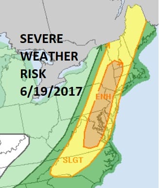
The Storm Prediction Center of the National Weather Service maintains an enhanced risk of severe weather late this afternoon and tonight from Eastern Virginia northward into Southern Vermont. This includes the major cities from Washington DC, Baltimore, Philadelphia, & New York City. A large slight risk of severe covers an even larger area from North Carolina to Maine. This is a widespread outbreak that is forecast covering a rather large geographic area of the east. The cold front is impressive and it stands out well this morning on the visible satellite loop. You can already see the beginnings of showers and thunderstorms developing to the west.
SATELLITE LOOP

REGIONAL RADAR

I’m not expecting much to happen until later this afternoon as thunderstorms develop over Eastern Pennsylvania and then spread eastward into Western New jersey right about the time the evening rush hour goes into full swing.
SEVERE WEATHER HRRR RAINFALL

We also have a Flash Flood Watch covering a large area from Eastern Pennsylvania, most of New Jersey except the coastal counties..New York City, the Hudson Valley northeast through Southern New England. Rainfall amounts of up to 3 inches could occur in some of the heavier thunderstorms. Weather models remain fairly consistent on this idea.
LOCAL RADAR NEW YORK CITY

LOCAL RADAR PHILADELPHIA


The HRRR model shows those storms moving across NYC around 6pm and holding together as they head across Long Island and Connecticut.
HRRR MODEL SEVERE WEATHER THIS EVENING CLICK TO ANIMATE

Once the front moves offshore tonight weather conditions should improve Tuesday and Wednesday with sunshine and clouds both days with lower humidity and highs into the 80s
 GET JOE A CIGAR IF YOU LIKE

LANDSCAPE COMPANIES FOR YOUR NEEDS
LONG ISLAND ROCKLAND COUNTY Connecticut

![]()

ROCKLAND COUNTY TRI STATE SNOW REMOVAL JOHNSTOWN PA


FiOS1 News Weather Forecast For Long Island
FiOS1 News Weather Forecast For New Jersey
FiOS1 News Weather Forecast For Hudson Valley
NATIONAL WEATHER SERVICE SNOW FORECASTS
LATEST JOESTRADAMUS ON THE LONG RANGE
Weather App

Don’t be without Meteorologist Joe Cioffi’s weather app. It is really a meteorologist app because you get my forecasts and my analysis and not some automated computer generated forecast based on the GFS model. This is why your app forecast changes every 6 hours. It is model driven with no human input at all. It gives you an icon, a temperature and no insight whatsoever.
It is a complete weather app to suit your forecast needs. All the weather information you need is right on your phone. Android or I-phone, use it to keep track of all the latest weather information and forecasts. This weather app is also free of advertising so you don’t have to worry about security issues with your device. An accurate forecast and no worries that your device is being compromised.
Use it in conjunction with my website and my facebook and twitter and you have complete weather coverage of all the latest weather and the long range outlook. The website has been redone and upgraded. Its easy to use and everything is archived so you can see how well Joe does or doesn’t do when it comes to forecasts and outlooks.
Just click on the google play button or the apple store button on the sidebar for my app which is on My Weather Concierge. Download the app for free. Subscribe to my forecasts on an ad free environment for just 99 cents a month.
Get my forecasts in the palm of your hand for less than the cost of a cup of Joe!


