Severe Weather Risk This Afternoon Evening Eastern PA New Jersey Hudson Valley
Severe Weather Risk This Afternoon Evening Eastern PA
New Jersey Hudson Valley
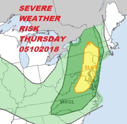
The Storm Prediction Center of the National Weather Service has a large area of slight risk of severe weather from Northeast Virginia to Eastern Pennsylvania eastward to western New England which includes Washington DC to Philadelphia the NYC. This has been upgraded somewhat from yesterday’s forecast. Showers are moving across Pennsylvania now but there will likely be other showers or thunderstorms that will develop later this afternoon and evening as a cold front approaches the coast.

Radars are beginning to pick up on a lead area of showers that are moving eastward. These do not appear especially problematic at the moment. Daytime heating will be key so how much cloud cover hangs around will effect the potential severity of thunderstorms. We will be watching to see if the Storm Prediction Center decides to put up a severe thunderstorm watch for parts of the area later today.


For coastal areas there is a marine layer that came in last night and wind off the ocean that will likely combine to weaken storms this evening as they near the coast. Weather conditions should improve tonight and Friday looks like a better day with some sunshine.
The weekend brings another front with the threat for some showers late Friday night into Saturday morning for some areas but there will likely be a stronger threat for thunderstorms late Saturday and Saturday night as a cold front sinks southward. That front is likely to get hung up on Mother’s Day keeping clouds and showers in the forecast.
FiOS1 News Weather Forecast For Long Island
FiOS1 News Weather Forecast For New Jersey
FiOS1 News Weather Forecast For Hudson Valley
NATIONAL WEATHER SERVICE SNOW FORECASTS
LATEST JOESTRADAMUS ON THE LONG RANGE