Severe Weather Risk Later Thursday
Severe Weather Risk Later Thursday
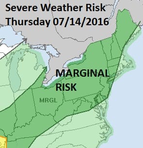
Marginal Risk Forecast

The Storm Prediction Center of the National Weather Service has placed the entire area from Northern Virginia and Maryland North and Northeastward through Pennsylvania, New York State and almost all of New England under a marginal risk for severe thunderstorms later Thursday afternoon and evening. Below is tonight’s risk area and while we are at risk for downpours or a thunderstorm overnight, we are not at risk for those storms becoming severe. Tonight’s downpours could be heavy rain makers as they move through. This is ahead of a warm front that will put us deep into tropical air and heat on Thursday.
Severe Weather Risk Overnight

Severe Weather Risk Later Thursday
Radar Loops


Overnight Forecast
Expect some downpours between 3am and 7am Thursday. Then look for clouds and some sun, high humidity and temperatures reaching into the 90s across New Jersey and mid to upper 80s everywhere else. With regards to late Thursday afternoon when a cold front begins to arrive, the dynamics are not the greatest. The atmosphere will be rather unstable but not crazy unstable. There will be a moisture rich air mass overhead. Dew points will be in the 70s. I would not be surprised if some storms grow strong or severe. Heavy rain could be a bigger threat but the line is forecast to move along rather than crawl through. The threat time from west to east will be from 3pm to 7pm.
FiOS1 News Weather Forecast For Long Island
FiOS1 News Weather Forecast For New Jersey
FiOS1 News Weather Forecast For Hudson Valley
NATIONAL WEATHER SERVICE SNOW FORECASTS
LATEST JOESTRADAMUS ON THE LONG RANGE
Weather App

Don’t be without Meteorologist Joe Cioffi’s weather app. It is really a meteorologist app because you get my forecasts and my analysis and not some automated computer generated forecast based on the GFS model. This is why your app forecast changes every 6 hours. It is model driven with no human input at all. It gives you an icon, a temperature and no insight whatsoever.
It is a complete weather app to suit your forecast needs. All the weather information you need is right on your phone. Android or I-phone, use it to keep track of all the latest weather information and forecasts. This weather app is also free of advertising so you don’t have to worry about security issues with your device. An accurate forecast and no worries that your device is being compromised.
Use it in conjunction with my website and my facebook and twitter and you have complete weather coverage of all the latest weather and the long range outlook. The website has been redone and upgraded. Its easy to use and everything is archived so you can see how well Joe does or doesn’t do when it comes to forecasts and outlooks.
Just click on the google play button or the apple store button on the sidebar for my app which is on My Weather Concierge. Download the app for free. Subscribe to my forecasts on an ad free environment for just 99 cents a month.
Get my forecasts in the palm of your hand for less than the cost of a cup of Joe!
![]()

MENTION JOE CIOFFI AND GET A 5% DISCOUNT