[brid video=”54680″ player=”6390″ title=”thursday”]
Heat Advisory Severe Weather Threat
Heat Advisory Severe Weather Threat
The two things going on today are the heat (and humidity which has prompted Heat Advisories From New York City and Northern New Jersey (except the northwest) southward with Excessive Heat Warning for Southwest New Jersey and Southeastern Pennsylvania.

The other issue is later this afternoon and evening with an approaching cold front. This has prompted the Storm Prediction Center to increase the risk of severe weather to slight risk for Northeastern Pennsylvania northeastward through Upstate New York and most of Western New England. This includes the Hudson Valley and Northwest New Jersey. A marginal risk of severe weather extends to the coast and the rest of New Jersey southward.
Heat Advisory Severe Weather Threat Storm Prediction Center Forecast

Heat Advisory Severe Weather Threat Latest Radar Loops


Heat Advisory Severe Weather Threat
Outlook For This Afternoon & Evening
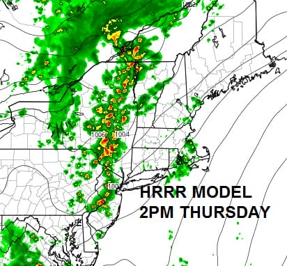
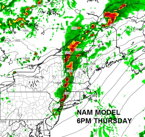
Two model views for this afternoon. Each is different in terms of magnitude and speed. The slower NAM model below has stronger thunderstorm activity as you go northward and it is also slower.
NAM MODEL 6PM THURSDAY
HRRR MODEL 2PM THURSDAY

The HRRR model has a longer stronger line further south and it is faster than the NAM model This would bring a severe weather threat for mid to late afternoon. So far there isn’t any clue on the regional radar with regards to which model is going to be right. So we will wait until we see some radar development and figure out which model has the better handle on things. The NAM has outperformed the HRRR model which has been very volatile lately in the short range.
Meanwhile with regards to the heat, temperatures will reach the 90s in the advisory area with high humidity so stay cool and avoid running marathons in the middle of the day.
FiOS1 News Weather Forecast For Long Island
FiOS1 News Weather Forecast For New Jersey
FiOS1 News Weather Forecast For Hudson Valley
NATIONAL WEATHER SERVICE SNOW FORECASTS
LATEST JOESTRADAMUS ON THE LONG RANGE
Weather App

Don’t be without Meteorologist Joe Cioffi’s weather app. It is really a meteorologist app because you get my forecasts and my analysis and not some automated computer generated forecast based on the GFS model. This is why your app forecast changes every 6 hours. It is model driven with no human input at all. It gives you an icon, a temperature and no insight whatsoever.
It is a complete weather app to suit your forecast needs. All the weather information you need is right on your phone. Android or I-phone, use it to keep track of all the latest weather information and forecasts. This weather app is also free of advertising so you don’t have to worry about security issues with your device. An accurate forecast and no worries that your device is being compromised.
Use it in conjunction with my website and my facebook and twitter and you have complete weather coverage of all the latest weather and the long range outlook. The website has been redone and upgraded. Its easy to use and everything is archived so you can see how well Joe does or doesn’t do when it comes to forecasts and outlooks.
Just click on the google play button or the apple store button on the sidebar for my app which is on My Weather Concierge. Download the app for free. Subscribe to my forecasts on an ad free environment for just 99 cents a month.
Get my forecasts in the palm of your hand for less than the cost of a cup of Joe!

MENTION JOE CIOFFI AND GET A 5% DISCOUNT