Severe Thunderstorm Watch Posted
[brid video=”55994″ player=”6390″ title=”severe”]
Severe Thunderstorm Watch Posted
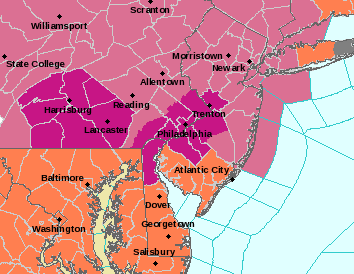
The Storm Prediction Center of the National Weather Service has posted a Severe Thunderstorm Watch for all of New Jersey except the extreme south, all of Pennsylvania, Southeastern New York, Hudson Valley, and Western Long Island until 8pm. The area in blue on the map below outlines the watch area.


SEVERE THUNDERSTORM WATCH
NEW JERSEY COUNTIES INCLUDED ARE BERGEN BURLINGTON CAMDEN ESSEX GLOUCESTER HUDSON HUNTERDON MERCER MIDDLESEX MONMOUTH MORRIS OCEAN PASSAIC SOMERSET SUSSEX UNION WARREN $$
NEW YORK COUNTIES INCLUDED ARE

ALLEGANY             BRONX               BROOME
CATTARAUGUS          CHAUTAUQUA          CHEMUNG
COLUMBIA             DELAWARE            DUTCHESS
GREENE               KINGS               NASSAU
NEW YORK             ORANGE              PUTNAM
QUEENS               RICHMOND            ROCKLAND
SCHUYLER             STEUBEN             SULLIVAN
TIOGA                TOMPKINS            ULSTER
WESTCHESTER

NEW JERSEY COUNTIES INCLUDED ARE

BERGEN BURLINGTON CAMDEN ESSEX GLOUCESTER
HUDSON HUNTERDON MERCER MIDDLESEX MONMOUTH MORRIS OCEAN PASSAIC SOMERSET
SUSSEX UNION WARREN

CONNECTICUT COUNTIES INCLUDED ARE

FAIRFIELD
PENNSYLVANIA COUNTIES INCLUDED ARE

ADAMS                ARMSTRONG           BEDFORD
BERKS                BLAIR               BRADFORD
BUCKS                CAMBRIA             CAMERON
CARBON               CENTRE              CHESTER
CLARION              CLEARFIELD          CLINTON
COLUMBIA             CUMBERLAND          DAUPHIN
DELAWARE             ELK                 FAYETTE
FOREST               FRANKLIN            FULTON
HUNTINGDON           INDIANA             JEFFERSON
JUNIATA              LACKAWANNA          LANCASTER
LEBANON              LEHIGH              LUZERNE
LYCOMING             MCKEAN              MIFFLIN
MONROE               MONTGOMERY          MONTOUR
NORTHAMPTON          NORTHUMBERLAND      PERRY
PHILADELPHIA         PIKE                POTTER
SCHUYLKILL           SNYDER              SOMERSET
SULLIVAN             SUSQUEHANNA         TIOGA
UNION                WARREN              WAYNE
WESTMORELAND         WYOMING             YORK
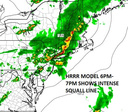
HRRR Model Forecast
The HRRR model shows a line of intense storms moving southeastward and arriving this evening. Both the NAM model and the HRRR model develop a rather intense squall line.
FiOS1 News Weather Forecast For Long Island
FiOS1 News Weather Forecast For New Jersey
FiOS1 News Weather Forecast For Hudson Valley
NATIONAL WEATHER SERVICE SNOW FORECASTS
LATEST JOESTRADAMUS ON THE LONG RANGE
Weather App

Don’t be without Meteorologist Joe Cioffi’s weather app. It is really a meteorologist app because you get my forecasts and my analysis and not some automated computer generated forecast based on the GFS model. This is why your app forecast changes every 6 hours. It is model driven with no human input at all. It gives you an icon, a temperature and no insight whatsoever.
It is a complete weather app to suit your forecast needs. All the weather information you need is right on your phone. Android or I-phone, use it to keep track of all the latest weather information and forecasts. This weather app is also free of advertising so you don’t have to worry about security issues with your device. An accurate forecast and no worries that your device is being compromised.
Use it in conjunction with my website and my facebook and twitter and you have complete weather coverage of all the latest weather and the long range outlook. The website has been redone and upgraded. Its easy to use and everything is archived so you can see how well Joe does or doesn’t do when it comes to forecasts and outlooks.
Just click on the google play button or the apple store button on the sidebar for my app which is on My Weather Concierge. Download the app for free. Subscribe to my forecasts on an ad free environment for just 99 cents a month.
Get my forecasts in the palm of your hand for less than the cost of a cup of Joe!
![]()

MENTION JOE CIOFFI AND GET A 5% DISCOUNT


