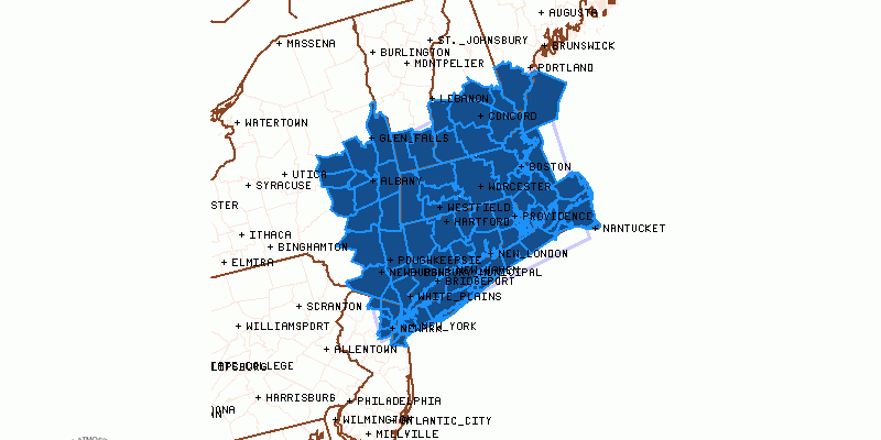
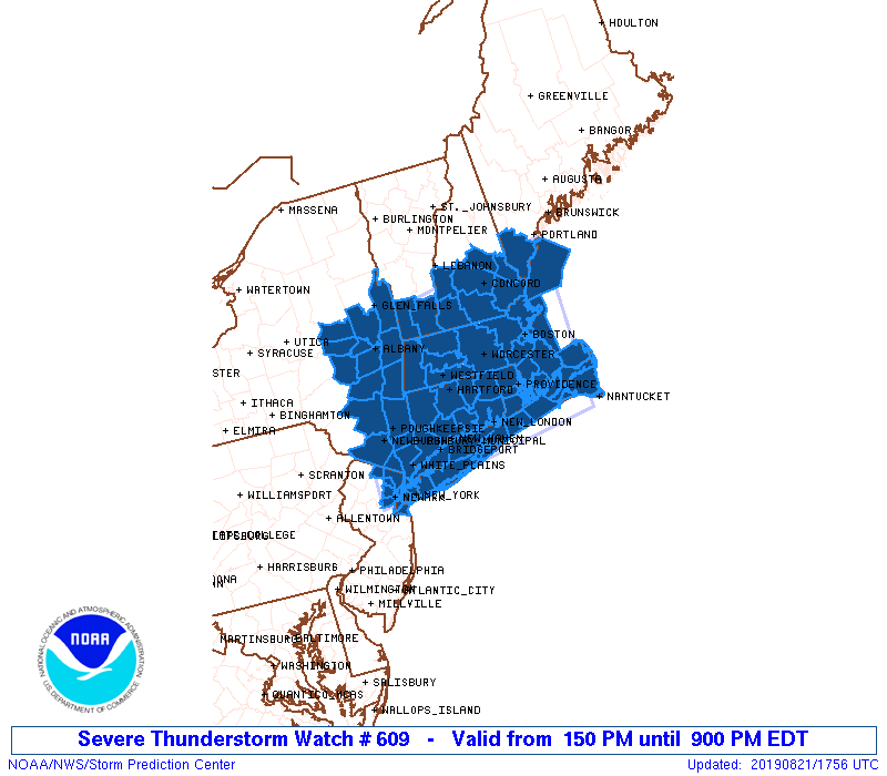
Severe Thunderstorm Watch Posted Through This Evening
The Storm Prediction Center has posted up a Severe Thunderstorm Watch until 9pm for areas from northeastern New Jersey northeast into most of Southern and Southeastern New England. Daytime heating is underway as temperatures are climbing through the 80s to near 90. Some thunderstorms have moved through the Hudson Valley and into Connecticut early this afternoon. Now we wait for the main area of thunderstorms to fire up to the west.
The NWS Storm Prediction Center has issued a
* Severe Thunderstorm Watch for portions of
Connecticut
Massachusetts
Far southern Maine
Southern New Hampshire
Northern New Jersey
Southeast New York
Rhode Island
Southern Vermont
Coastal Waters
* Effective this Wednesday afternoon and evening from 150 PM
until 900 PM EDT.
* Primary threats include…
Scattered damaging wind gusts to 70 mph possible
Isolated large hail events to 1.5 inches in diameter possible
A tornado or two possible
SUMMARY…Storms will continue to develop and intensify particularly
across far eastern New York and southern New England, near and south
of a warm front that will continue to spread slowly northward. Some
supercells with a hail/tornado risk aside from damaging winds are
most probable across southern New England, with damaging winds
otherwise expected with the strongest storms.
The severe thunderstorm watch area is approximately along and 85
statute miles north and south of a line from 30 miles west northwest
of Poughkeepsie NY to 40 miles east of Boston MA. For a complete
depiction of the watch see the associated watch outline update
NEW JERSEY COUNTIES INCLUDED ARE
BERGEN ESSEX HUDSON
PASSAIC UNION
NYC001-005-021-027-035-039-047-057-059-061-071-079-081-083-085-
087-091-093-095-103-111-115-119-220100-
/O.NEW.KWNS.SV.A.0609.190821T1750Z-190822T0100Z/
NY
. NEW YORK COUNTIES INCLUDED ARE
ALBANY BRONX COLUMBIA
DUTCHESS FULTON GREENE
KINGS MONTGOMERY NASSAU
NEW YORK ORANGE PUTNAM
QUEENS RENSSELAER RICHMOND
ROCKLAND SARATOGA SCHENECTADY
SCHOHARIE SUFFOLK ULSTER
WASHINGTON WESTCHESTER
CONNECTICUT COUNTIES INCLUDED ARE
FAIRFIELD HARTFORD LITCHFIELD
MIDDLESEX NEW HAVEN NEW LONDON
TOLLAND WINDHAM
SATELLITE

REGIONAL RADAR

The warm front has moved north of NYC and is progressing northward. The regional radar is showin a line from New Hampshire to Western Connecticut. Nothing much is on the radar yet to the west in Eastern Pennsylvania but storms should fire up going into this evening.
LOCAL RADAR NEW YORK CITY

LOCAL RADAR PHILADELPHIA 

This is the first of two fronts moving through. It will remain warm and humid tonight with lows in the upper 60s to mid 70s. Thursday brings a second front through in the evening. It will be hot ahead of it with a west wind and sunshine. Highs will reach the upper 80s to lower 90s. We should see ample daytime heating with this and solid upper trough approaching so there is another risk for severe weather on Thursday. The Storm Prediction Center has upped the risk for Thursday to marginal risk.

The second cold front will move offshore early Friday morning and there might be some leftover showers around into daybreak or a bit beyond daybreak before we see decreasing clouds and increasing sunshine with much lower humidity. Highs Friday will just be in the upper 70s to around or just over 80. There are no changes in the outlook for the weekend with cool temperatures and sunshine Saturday and a mix of sun and clouds for Sunday. Highs both days will be in the 70s with an ocean wind developing. The humidity will be low through the weekend.
MANY THANKS TO TROPICAL TIDBITS FOR THE USE OF MAPS
Please note that with regards to any tropical storms or hurricanes, should a storm be threatening, please consult your local National Weather Service office or your local government officials about what action you should be taking to protect life and property.


