
Scattered Snow Showers Around Otherwise Quiet Through Wednesday,
Snow Chance Thursday With Cold Front

Weather in 5/Joe & Joe Weather Show Latest Podcast
Scattered Snow Showers Around Otherwise Quiet Through Wednesday,
Snow Chance Thursday With Cold Front
Our storm system continues to move northeastward through upstate NY and New England. The upper low is moving through this evening and we can see some clouds on the satellite at the bottom of the upper low. This is producing a few scattered snow showers and we can seem them on the radar. There isn’t much too them. Some areas that get into these snow showers will see flurries or perhaps enough to whiten the ground in spots. Once they play through and the upper low goes to to the north, weather conditions should start to improve. Skies should start to clear out tonight with most lows in the 20s.
SATELLITE

WEATHER RADAR

Tuesday will be a better day with skies becoming partly to mostly sunny. Most highs will be in the 30s. North and northwest of NYC it will be a little colder in the upper 20s while southern areas like Southern Pennslvania and Southern New Jersey southward will be in the mid to upper 30s. On to Wednesday where we warm up a little ahead of a cold front. We should see sunshine most of the day with highs reaching back into the 40s.
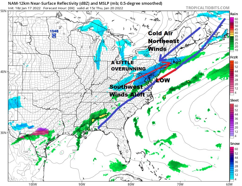
We have a bit of an interesting situation for Thursday with this front. Normally these fronts go by with a couple of rain showers ahead of it and it clears out and turns colder behind it with no issues. This time it is a little different. We have a front going through and due to a little ridge off the East Coast, the front slows down. A weak flat little wave develops on it and it results in some snow behind the front. Cold air comes in quick on a northeast wind. Aloft we have a southwest wind which sets up some overrunning snow. It is the sort of system that give maybe a coating to a few inches in some places. It is also the type of system that the NAM model tends to do well with. We will see how this goes and if we still see it tomorrow on the models, then we will figure out what if anything we get from it. We will mention the chance for a period of snow Thursday for the time being and leave it at that.

The weekend is in a state of flux as well as the front will remain stalled in the Southeast US and another stronger wave will emerge from this and head for the Southeast Coast. It could get suppressed to the southeast leaving us just with clouds later Friday night and Saturday but there are some hints it could wind up further north. Once again we are dealing with an upper air with lots of players running around and several possibilities of outcomes ranging from nothing to something more important. The dynamic active pattern continues into next week as very cold air comes out of Canada leaving us with essentially additional puzzles to solve.
BE SURE TO DOWNLOAD THE FREE METEOROLOGIST JOE CIOFFI WEATHER APP &
ANGRY BEN’S FREE WEATHER APP “THE ANGRY WEATHERMAN!

MANY THANKS TO TROPICAL TIDBITS & F5 WEATHER FOR THE USE OF MAPS
Please note that with regards to any severe weather, tropical storms, or hurricanes, should a storm be threatening, please consult your local National Weather Service office or your local government officials about what action you should be taking to protect life and property.


