Record Highs Possible As Dry Spell Continues Into Next Week
Cooler Air Arrives Thursday

Record Highs Possible As Dry Spell Continues Into Next Week
Cooler Air Arrives Thursday

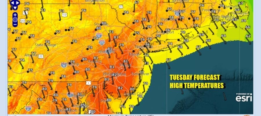
The warmest 2 days of this latest stretch of dry weather, and it has been a very long stretch will take temperatures up into the 80s in many locations and this means that some stations could see record highs. We have another day of cloud free conditions from start to finish. October is known for having the highest number of clear days and nights as compared to other months of the year. Enjoy the mostly sunny skies. Temperatures will likely be a few degrees lower along the coastal areas of New Jersey, Long Island and Southern New England. Radars obviously are nice and quiet.
SATELLITE WITH LIGHTNING STRIKES

WEATHER RADAR

We have some subtle changes in the weather pattern going forward that will allow for cold fronts to start passing through from west to east. The problem however is that even though weather systems will resume their normal west to east progression, the Atlantic and Ocean and the Gulf of Mexico essentially remain cut off as a moisture source so these fronts will come through basically dry.

The first of two weather fronts will come through Wednesday and you will hardly notice it other than a few passing clouds and a wind shift to the west and northwest. Wednesday should be no worse than partly sunny. Leftover warm air will mean highs will be in the mid to upper 70s but we will cool down at night with most lows in the 50s..

Thursday sees cooler air spreading southeast from Upstate NY and Eastern Canada as high pressure builds in. Skies should be partly to mostly sunny but it will be noticeably cooler with highs in the low to middle 60s. By Friday morning we will be down to the mid 30s to lower 40s under clear skies Friday will be rather cool with sunshine. 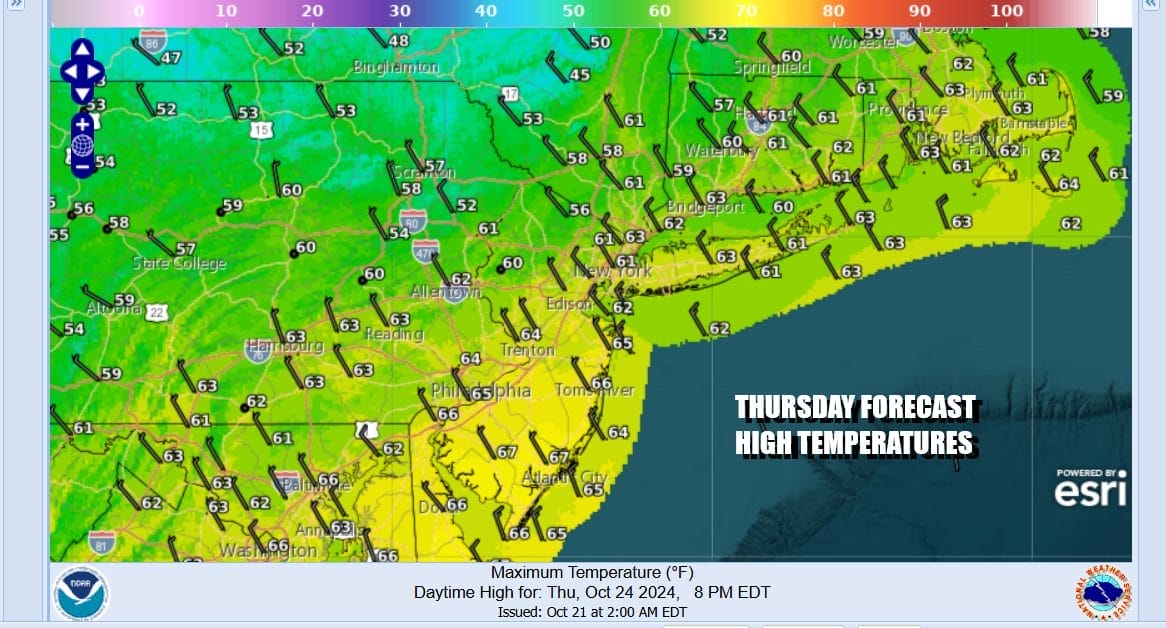
Most highs Friday might not get out of the 50s north and northwest of the coast while areas south of NYC and Philadelphia will be in the lower 60s. Another weather front arrives late Friday night or early Saturday and there will be clouds and maybe, just maybe, a passing shower. If it does rain it will be short and insignificant. It will leave us with some sunshine developing Saturday with highs in the low to mid 60s. Sunday will be chilly with sunshine and most highs in the 50s. We likely will see another significant warm up next week into Halloween and we could finish out October without a drop of rain in many areas from Eastern Pennsylvania to Southern New England.
BE SURE TO DOWNLOAD THE FREE METEOROLOGIST JOE CIOFFI WEATHER APP &
ANGRY BEN’S FREE WEATHER APP “THE ANGRY WEATHERMAN!
MANY THANKS TO TROPICAL TIDBITS FOR THE USE OF MAPS
Please note that with regards to any severe weather, tropical storms, or hurricanes, should a storm be threatening, please consult your local National Weather Service office or your local government officials about what action you should be taking to protect life and property.


