
Record High Temperatures For Long Island
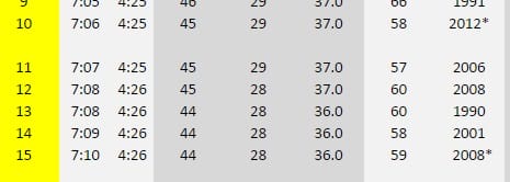
The first record high is hit today as Islip as the temperatures are already in the upper 50s. The record today was 58 set back in 2012 and we have already taken that record out and more are coming over the next several days.
With that big ridge along the east coast this weekend it is quite likely that we will take out the records Friday through Sunday or even through Monday if the rain holds off long enough. We only need to get to 60 and we should make that each day. The only things that prevents that from happening are either clouds which are possible from time to time and a wind off the ocean. We are enjoying sunshine and a light west wind today so have fun being outside in minimal winter clothing right through Sunday.
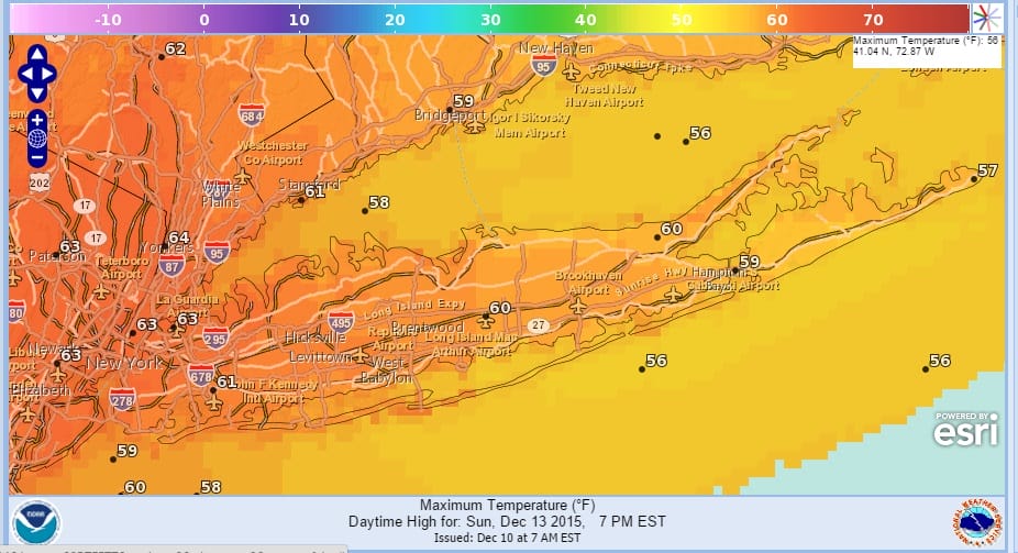
The satellite does show several weak disturbances moving along but all the rain with any of this will be moving by to our north through Sunday so no rain is indicated in the forecast. Highs today should reach the lower 60s..Nights will features some clouds and maybe a little patchy fog over time as the airmass stagnates a bit over the coming days but no big issues are forecast right through the weekend.


The first important change in our weather will come on Monday for Long Island as a strong cold front approaches. Monday will be the last day of record high temperatures as that front will being a gradual return to more normal weather conditions as next week moves along. Longer term the weather forecast models are showing a change or at least a transition occuring over the coming weeks across much of the United States Be sure to check the links below for the latest on these changes. Meanwhile enjoy the warm weather over the next several days since we know that it is not going to last forever.
Here is the latest FiOS1 Weather forecast with Meteorologist Geoff Bansen. Joe Cioffi will have the latest tonight beginning at 5pm.
YOU TUBE VIDEO ANALYSIS OF LONG RANGE PATTERN
HEAVY RAIN POSSIBLE WITH COLD FRONT ON MONDAY
MODELS DIVERGE ON LONG RANGE OUTLOOK
JOESTRADAMUS HAS THE LATEST ON THE LONG RANGE
LONG ISLAND SHORT TERM FORECAST
NEW JERSEY SHORT TERM FORECAST
NEW YORK CITY SHORT TERM FORECAST
JOESTRADAMUS ON RISING TEMPERATURES AND VIDEO ANALYSIS