
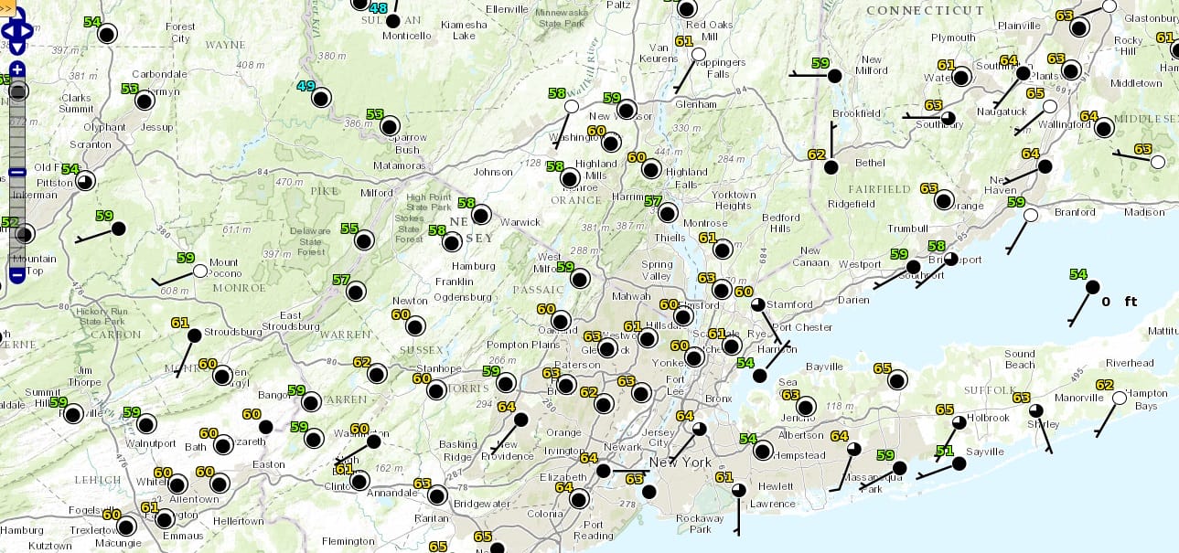
Record High Temperatures Everywhere!!!
It was an utterly amazing day with records set at many locations. Here are a few record high temperatures. Even where records weren’t set we saw temperatures into the 70s!
RECORD EVENT REPORT
NATIONAL WEATHER SERVICE NEW YORK NY
1112 AM EST SAT DEC 12 2015

...RECORD HIGH TEMPERATURE SET AT LAGUARDIA NY...

A RECORD HIGH TEMPERATURE OF 64 DEGREES WAS SET AT LAGUARDIA NY
TODAY. THIS BREAKS THE OLD RECORD OF 62 SET IN 1983.
...RECORD HIGH TEMPERATURE SET AT ISLIP NY...

 A RECORD HIGH TEMPERATURE OF 66 DEGREES WAS SET AT ISLIP NY
TODAY. THIS BREAKS THE OLD RECORD OF 60 SET IN 2008.

...RECORD HIGH TEMPERATURE SET AT BRIDGEPORT CT...

A RECORD HIGH TEMPERATURE OF 60 DEGREES WAS SET AT BRIDGEPORT CT
TODAY. THIS BREAKS THE OLD RECORD OF 58 SET IN 2008.

AN UPDATE TO THIS RECORD WILL BE ISSUED IF THE TEMPERATURE EXCEEDS
60 DEGREES THIS AFTERNOON.


Nothing much is happening other than some clouds beginning to roll in and we are pretty much past the maximum daytime heating part of the day so temperatures will begin to ease some but not much. Tomorrows highs will hinge on clouds and wind direction however we will be starting off from a high launching pad as lows tonight may not break 50 especially in warmer urban locations. Sunday’s highs should be in the 60s.
Monday we will see the next cold front approach and some downpours and even a thunderstorm will come into the picture during Monday and into Monday evening. Here are the rainfall amounts forecast through Monday evening.
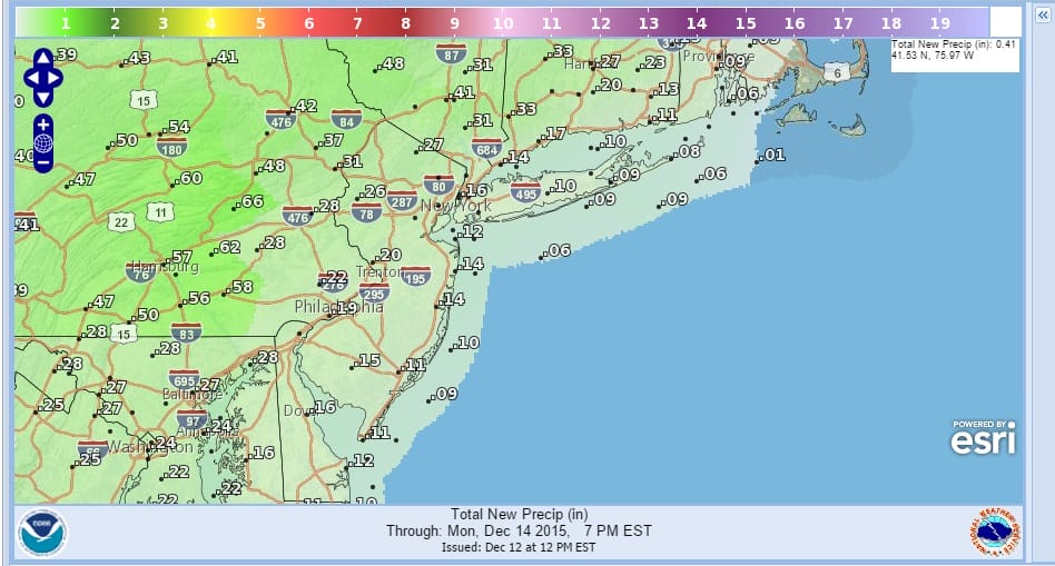
There will be another period of rainfall beyond 7pm Monday to add to this and hopefully we get something meaningful out of all this. Models today all pointing to a shot of cold air coming for next weekend that won’t last more than a couple of days though the European does have a slightly colder look to the start of Christmas week versus the GFS model which starts another warmup. More on this later though it doesn’t really change the course of things. We are on track to have the warmest December on record, even if the second half of the month is closer to normal.
If you are wondering where the snow is, here is a map of snow cover in the United States and Southern Canada. Meanwhile more record high temperatures are possible on Sunday.

JOESTRADAMUS VIDEO ANALYSIS ON THE LONG RANGE
NEW YORK CITY & HUDSON VALLEY FORECAST
SNOW FORECAST SKI RESORTS