Rainy Sunday Severe Weather Possible South Jersey Southward Coastal Flood Advisory
The awaited miserable Sunday is here and we are seeing a low pressure over the Great Lakes this morning which is the oh so obvious swirl on the satellite picture below with a large arc of rain and even a few thunderstorms starting to show up from Upstate NY and Central Pennsylvania eastward to the coast. The warm front this morning is moving through Northern Virginia and Maryland.
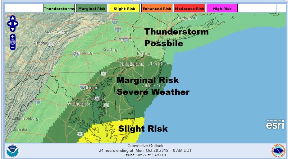
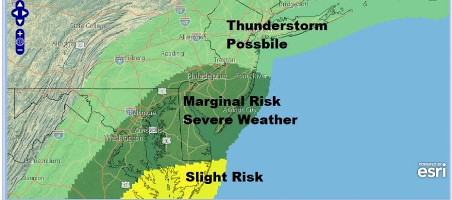
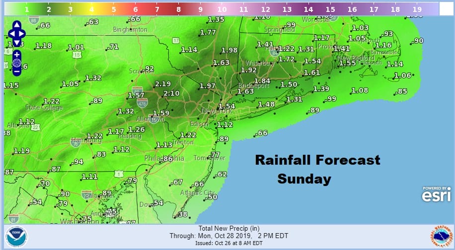
This sets up the possibility of severe weather and the Storm Prediction Center has a marginal risk reaching up into New Jersey to right along Route 195. Slight risk of severe is in the Delmarva Peninsula back to Southeastern Virginia. Most of the area will receive 1 to 2 inches of rain especially in areas that see a thunderstorm in the mix. Coastal Flood Advisories are up for high tide with minor coastal flooding possible for Long & New Jersey shore lines as well as for NY Harbor.
SATELLITE

REGIONAL RADAR

Regional an local radars are rather loaded this morning with rain and patches of moderate to heavy rain especially to the west and that rain moves in late this morning-early this afternoon through much of Eastern Pennsylvania to Southern New England. The local radars are all loaded up as well. It is pretty much a washout for this Sunday.
LOCAL RADAR NEW YORK CITY

LOCAL RADAR PHILADELPHIA


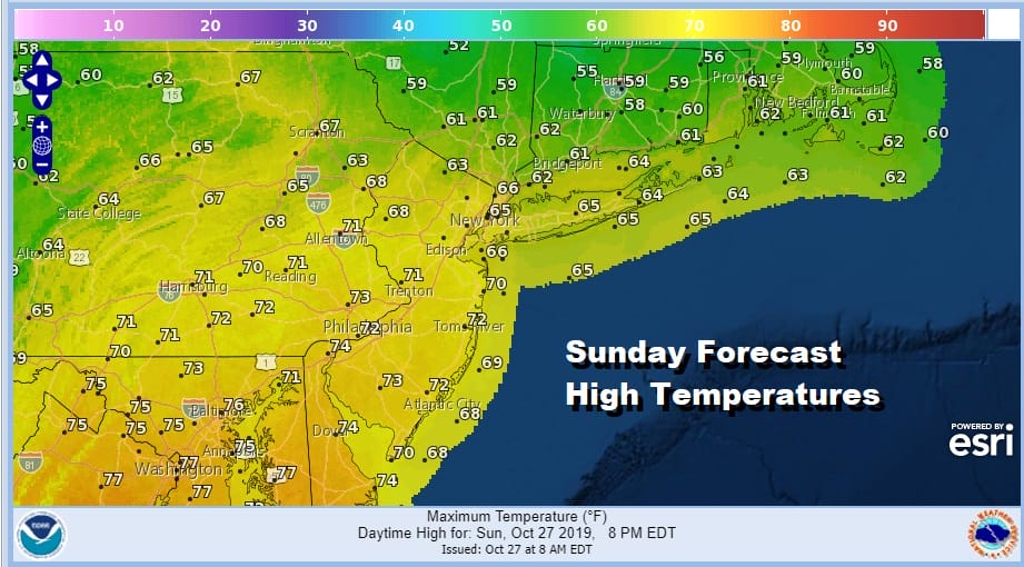
Watch for some thunderstorms in the mix this afternoon until the cold front passes. Temperatures today could actually reach into the 70s from Southern New Jersey southward while it will remain in the rather raw low and middle 60s Northern New Jersey to Southern New England and Long Island. This should all end from west to east during the mid to late afternoon.
Weather conditions improve tonight. We should see skies partially clear out and Monday will be a partly sunny day with highs in the 60s. An onshore flow and a weak low backing westward from offshore will bring clouds and the chance for some patchy light rain Monday night and Tuesday with highs Tuesday in the 60s. Wednesday we go back to some sunshine with highs in the 60s.
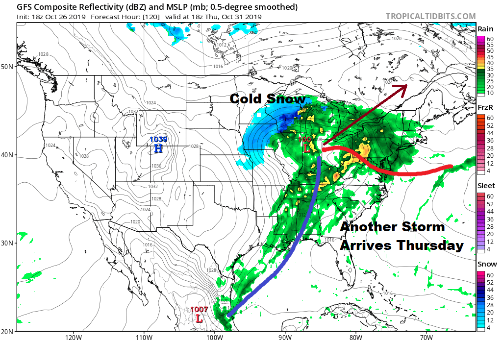
Everything is on course for yet another strong storm to head to the Great Lakes on Thursday which could wind up being a repeat performance of today with rain developing around midday and lasting through Thursday night into early Friday morning. It could be another 1 inch plus system with a warm front and the chance for thunderstorms in some places. We will look ahead to this in greater detail later today or tonight. Halloween doesn’t look especially promising.
MANY THANKS TO TROPICAL TIDBITS FOR THE USE OF MAPS
Please note that with regards to any severe weather, tropical storms, or hurricanes, should a storm be threatening, please consult your local National Weather Service office or your local government officials about what action you should be taking to protect life and property.


