Rainy Night Ahead Before Some Improvement Tuesday Snow 1 to 3 Inches Wednesday
The only way to describe today would be with the word miserable and those conditions this evening and through much of tonight. We have rain with some patches of heavy rain going on during this evening’s commute. Then we have dense flog in areas north of Route 84 in the Hudson Valley where we have warm moist air rolling over snow cover and a cold ground. This makes for a difficult commute this evening so take it slow. Weather conditions won’t improve much overnight other than the rain which should move out from west to east around midnight or so in most places.
SATELLITE

REGIONAL RADAR

We have loaded regional and local radars this evening with heavy rain showing up in the yellow echos. It seems like it is raining just about everywhere. Temperatures in many coastal areas are in the 50s and have been all day while inland north and west of the coast we see temperatures still stuck in the 40s and 30s especially up north in the Hudson Valley and Northern Connecticut northward.
LOCAL RADAR NEW YORK CITY

LOCAL RADAR PHILADELPHIA


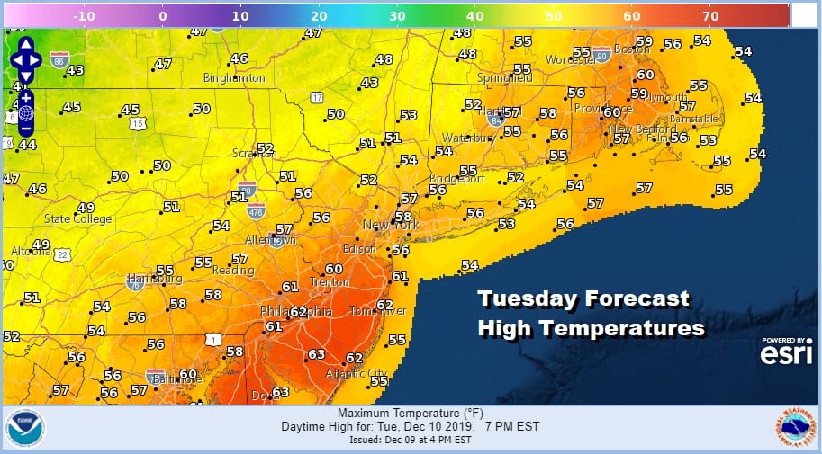
Once the rain ends we have quiet times for Tuesday into the afternoon as we wait for the cold front to come through late in the day. There could be a few showers around during the afternoon as the front passes. Temperatures will be in the upper 50s and lower 60s which of course won’t last long.
The front passes Tuesday evening and temperatures start to fall. Our cold front is stalled to the east and south and one more wave of low pressure will move along it. We will see snow develop during the early morning hours on Wednesday with rain along the coast that will turn to snow before daybreak.

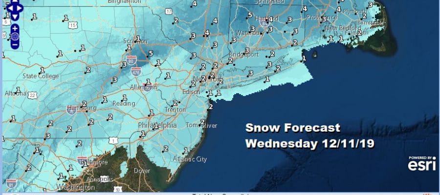
You can see on the late afternoon NAM model run just how flat and fast this system is going to be with it lasting no more than 6 hours from start to finish. Everything needs to land just right regarding temperatures and precipitation. In situations like this it is all about timing. We have the National Weather Service snow forecast maps up which i believe may be a bit too high in the max area north and northeast of the coast.
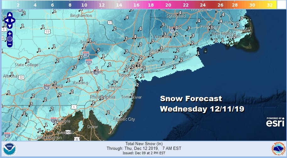
We have basically broadbrushed an area of 1 to 3 inches in yesterday’s early call snow forecast map from Northeast Virginia to Southern New England and see no real need to change anything at this stage of the game. Given the very flat nature of this set up I don’t see a lot of room for upside.

Once all this is done it will turn colder into Thursday morning with lows in the teens inland and low to mid 20s along coastal areas and the warmer urban centers. Highs on Thursday will be just into the 30s. This next cold high moves very quickly out to the east and low pressure from the Gulf States will move northward up the Appalachians Friday into early Saturday with mostly a rain event here.

This system moves very quickly and it looks like it will be in during Friday afternoon and evening and gone by Saturday morning. It looks like it could be a solid rain producer with strong southeast gales along the coast. It gets colder behind it and it could set us up for another weather system and a chance for snow or rain early next week.
BE SURE TO DOWNLOAD THE FREE METEOROLOGIST JOE CIOFFI WEATHER APP &
ANGRY BEN’S FREE WEATHER APP “THE ANGRY WEATHERMAN!
MANY THANKS TO TROPICAL TIDBITS FOR THE USE OF MAPS
Please note that with regards to any severe weather, tropical storms, or hurricanes, should a storm be threatening, please consult your local National Weather Service office or your local government officials about what action you should be taking to protect life and property.


