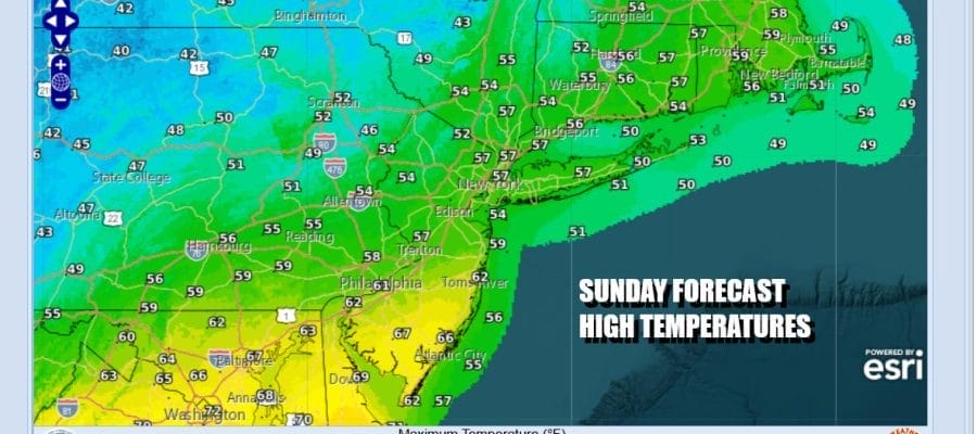

Rain Later Today & Tonight Cold Weather For The Week Ahead

We have a cold front moving southward today and it is a slow moving front at that. Ahead of this front clouds are rolling in from the west and we are seeing a busy regional radar with and some heavier downpours to the northwest. This rain area will gradually shift southward as the day wears on but it will likely weaken as it does so. A wave develops on the front and this is going to bring another area of rain up from the south. Here too the rain area is likely to be patchy and on the weak side. In between all this you can expect mainly cloudy skies and temperatures today will be in the 50s with a few lower 60s in South Jersey and points southward.
SATELLITE WITH LIGHTNING STRIKES

WEATHER RADAR

Severe weather risk is not an issue today for Eastern Pennsylvania to Southern New England as the warm sector sets up from Virginia southward to the Eastern Gulf States from Alabama to North Florida. The wave will move northeast and not develop much but the front will continue to slowly press southward tonight into Monday morning. Some patchy rain will continue overnight into the first part of Monday.

Monday we see low pressure moving across Southeastern Canada and strengthening along the way. Rain ends from west to east Monday but clouds will likely be around all day. Temperatures Monday are going to be cold as northerly winds bring down cold Canadian air. Monday temperatures will be in the 40s area wide all day long. along with a gusty northwest wind that develops making it feel rather chilly.
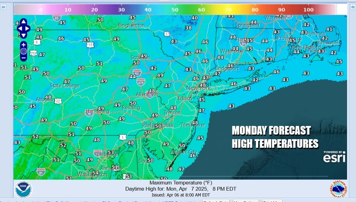
This is going to be a very chilly week indeed. Average highs this time of year are in the lower 60s and we are going to see at least 2 days with daytime highs not out of the 40s. Monday will be one. Tuesday will be a second and Wednesday for some places will be the third. Skies clear out Monday night with lows by Tuesday morning generally in the upper 20s inland and low to mid 30s coast and warmer urban locations.
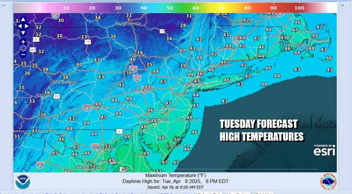
Tuesday dayside brings sunshine and gusty winds from the northwest. It will be another day of temperatures not out of the 40s anywhere which is at least 15 and in some places 20 degrees below average. This would be the equivalent of a January day where temperatures have a tough time getting out of the teens. Tuesday night into Wednesday morning will be very cold with lows in the 20s except for near or just over 30 for warmer urban locations and the coast.
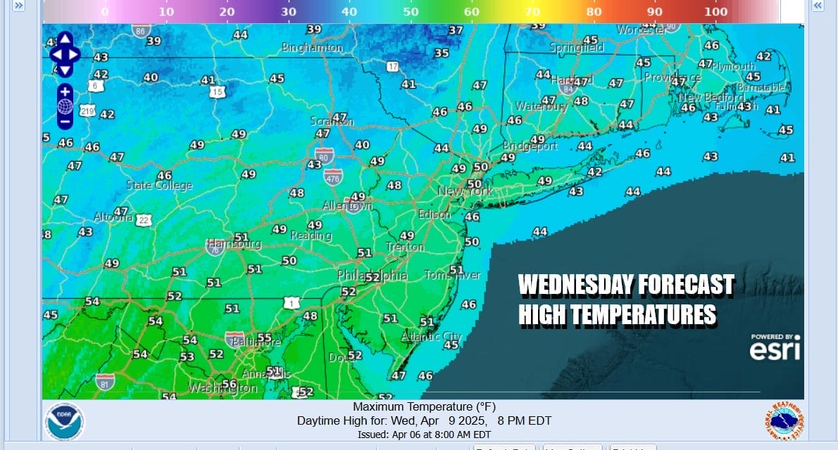
Wednesday we will see winds drop off some and we will also see sunshine but high temperatures will likely still have a tough time getting out of the 40s. Low pressure is going to approach on Thursday with a warm front first and then a cold front to follow. Temperatures should warm into the 50s and we could see some rain or showers at some point later Thursday into early Friday. After that the southern end of the front stalls along the coast and energy dropping from Canada looks to set off a developing low in the Carolinas that will move northward over the weekend. This likely means another not so nice and wet next weekend. It is that time of year folks. Spring in the Northeast and Northern Mid Atlantic states is simply not a very nice time of year.
BE SURE TO DOWNLOAD THE FREE METEOROLOGIST JOE CIOFFI WEATHER APP &
ANGRY BEN’S FREE WEATHER APP “THE ANGRY WEATHERMAN!
MANY THANKS TO TROPICAL TIDBITS FOR THE USE OF MAPS
Please note that with regards to any severe weather, tropical storms, or hurricanes, should a storm be threatening, please consult your local National Weather Service office or your local government officials about what action you should be taking to protect life and property.


