
Rain Holds Off Until Morning For Long Island
The fight tonight between dry air to the north and mois air to the south continues. Rain is trying to sneak northward but I think that any steady rain doesn’t get into Nassau County until daybreak and it may take longer to get into Suffolk County on Tuesday. Eventually it does get in here and we should see on and off rain on Tuesday. Tonight’s temperatures will fall between 38 and 44 giving it a raw cold feel out there. Tuesday we should creep up through the 40s and reach the low 50s tomorrow evening. Wednesday ahead of a cold front tempertures should reach the upper 50s to around 60.


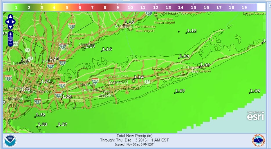
For now you can see the radar echos to the south is moving more east than north but that will gradually change as the high off the New England coast finally gives way. The rain will come in waves so there will definitely be some breaks in between. Latest rainfall forecasts for the next 2 days could total over an inch and that is the hope. A 2 day rainfall has not occurred on Long Island in many months. Afternoon weather models have grown a little more bullish on total rain forecasting between 1.25 inches and 1.75 inches. Perhaps we could wind up outperforming the models this time around.
Thursday through Sunday look dry with near or slightly above normal temperatuers forecast. No real cold air is in sight through the weekend and probably through the middle of next week. Check out the latest long range JOESTRADAMUS forecast for the longer term weather pattern outlook into mid December.
FREEZING RAIN POSSIBLE TONIGHT IN NORTHWEST NEW JERSEY
FREEZING RAIN POSSIBLE TONIGHT IN PARTS OF THE HUDSON VALLEY
JOESTRADAMUS ON THE LONG RANGE
SKI RESORTS WILL BE LACKING SNOW IN THE EAST BUT LOTS OF SNOW OUT WEST
SHORT RANGE FORECAST FOR NEW YORK, NEW JERSEY, CONNECTICUT, PENNSYLVANIA