
Rain Friday Showers Linger Weekend
Rain Friday Showers Linger Weekend
We are seeing everything pretty much stay on course for Friday. Clouds continue to gather and move northward this evening. There is rain well north and west of our area at the moment as the regional radar shows below but that rain isn’t headed here. The rain that is headed here is in the Southeast US where the satellite loop this evening shows a blossoming area of showers and thunderstorms. There are no rain related weather issues tonight through midnight. Rain will arrive during the early morning hours across Southern Pennsylvania and Southern New Jersey and then gradually lift northward. It should be raining in most areas by 7am. It may take a little longer for the rain to get into Connecticut and Long Island but it should be there by mid morning.
SATELLITE LOOP

REGIONAL RADAR

Regional radar shows the rain to the northwest this evening which is not an issue for us and it you all see the rain to the south in Virginia and North Carolina that will eventually be an issue for us on Friday.
LOCAL RADAR NEW YORK CITY

LOCAL RADAR PHILADELPHIA


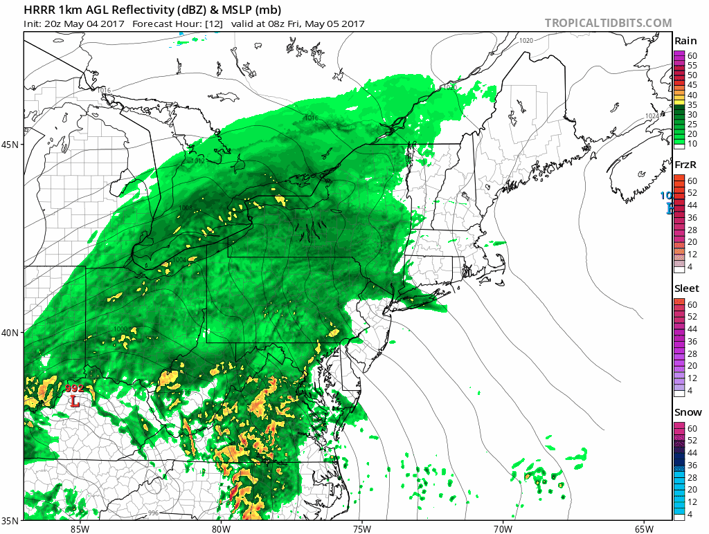
The latest HRRR model takes us through 10am Friday and at it is at this point that heavy rain will be spreading across New Jersey and eventually for Long Island and the Hudson Valley.
RAIN FRIDAY ON HRRR MODEL CLICK TO ANIMATE
Weather conditions will start to improve from south to north late in the afternoon across New Jersey and in the Early Evening on Long Island and Southern New England. Temperatures on Friday will be generally in the upper 50s and lower 60s but it could be warmer over Central & South Jersey & Southeast Pennsylvania with the low tracking to the west.
Over the weekend and into early next week the chance for showers will continue though it does not rain all the time and not everyone will see showers. The threat however is there so plan accordingly. Cool conditions will prevail beginning Sunday and lasting through much of next week. Also the threat for showers will continue into Monday and possibly Tuesday.
For more on the long range check out JOESTRADAMUS’S latest post.
 GET JOE A CIGAR IF YOU LIKE

LANDSCAPE COMPANIES FOR YOUR NEEDS
LONG ISLAND ROCKLAND COUNTY Connecticut

![]()

ROCKLAND COUNTY TRI STATE SNOW REMOVAL JOHNSTOWN PA


FiOS1 News Weather Forecast For Long Island
FiOS1 News Weather Forecast For New Jersey
FiOS1 News Weather Forecast For Hudson Valley
NATIONAL WEATHER SERVICE SNOW FORECASTS
LATEST JOESTRADAMUS ON THE LONG RANGE
Weather App

Don’t be without Meteorologist Joe Cioffi’s weather app. It is really a meteorologist app because you get my forecasts and my analysis and not some automated computer generated forecast based on the GFS model. This is why your app forecast changes every 6 hours. It is model driven with no human input at all. It gives you an icon, a temperature and no insight whatsoever.
It is a complete weather app to suit your forecast needs. All the weather information you need is right on your phone. Android or I-phone, use it to keep track of all the latest weather information and forecasts. This weather app is also free of advertising so you don’t have to worry about security issues with your device. An accurate forecast and no worries that your device is being compromised.
Use it in conjunction with my website and my facebook and twitter and you have complete weather coverage of all the latest weather and the long range outlook. The website has been redone and upgraded. Its easy to use and everything is archived so you can see how well Joe does or doesn’t do when it comes to forecasts and outlooks.
Just click on the google play button or the apple store button on the sidebar for my app which is on My Weather Concierge. Download the app for free. Subscribe to my forecasts on an ad free environment for just 99 cents a month.
Get my forecasts in the palm of your hand for less than the cost of a cup of Joe!


