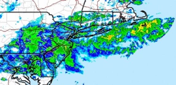
Satellite and radar continue to show a rather large area of rain slowly moving from Virginia and Southern Pennsylvania northeastward so it looks like the evening rush hour drive in and around New York City and Philadelphia will be on the wet side. At some point the back edge of that rain should lift to the northeast and the rain will probably start to taper off later this evening.


The radar centered further west shows more rain in the Tennessee Valley and into Western Virginia. There is a little gap in between the 2 areas so I’m anticipating a bit of a break here in the rain at some point overnight only to start up again later tonight into the Wednesday morning rush hour drive. Each wave does a good job in putting down at least a quarter to a half inch so I think by the time this is all done late Wednesday evening that average rainfall forecast of 1 to 2 inches is looking pretty good. A cold front will be swinging through here tomorrow evening which will push on through. Dry air and some sunshine will be here for Thursday along with a few leftover clouds in the mix.
Temperatures will be a bit of a struggle this evening in some inland areas as the cold air from yesterday is stubborn. Some patchy fog could develop overnight as well. Eventually milder air gets in here for Wednesday with temperatures in the 50s from Philadelphia to NYC to Coastal Connecticut south and east but north and west of that line temperatures my struggle in the 40s to near 50 as the warm air has a tough time mixing down to the surface.
Beyond Thursday other than clouds the weather looks pretty uneventful for Friday and the weekend with temperatures close to or a little above normal.
JOESTRADAMUS LONG RANGE POST TUESDAY
JOESTRADAMUS LONG RANGE POST FROM MONDAY
JOESTRADAMUS WINTER FORECAST 2015-2016
More long range analysis coming later this evening.