Parade of Winter Storms Lie Ahead For the Upcoming Work Week
As Active Pattern Continues

Parade of Winter Storms Lie Ahead For the Upcoming Work Week
As Active Pattern Continues
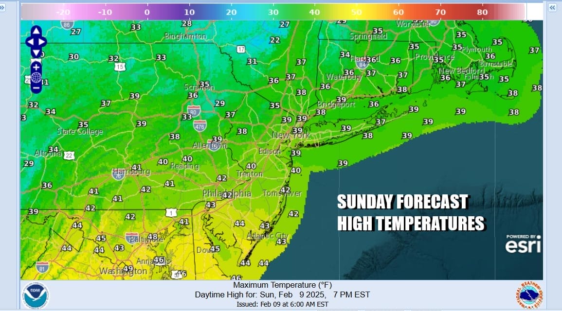
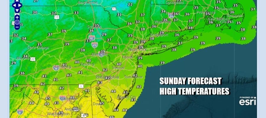
Last night’s heavy snow only lasted a few hours for most but it put down a solid 3 to 5 inches across Northern New Jersey (North of Route 78) the Hudson Valley, Connecticut, and (surprise), Long Island which would up in the jackpot zone. We have some leftover clouds to work through today but we should see developing sunshine later on and highs will reach the upper 30s and lower 40s. Colder air is coming in tonight as skies clear. Lows will be in the upper teens inland and low to mid 20s coast and warmer urban areas.
SATELLITE WITH LIGHTNING STRIKES

WEATHER RADAR

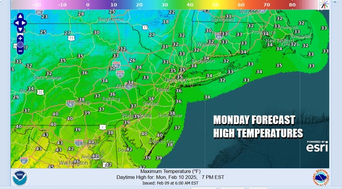
Monday looks to be a nice day as high pressure takes control over the Ohio Valley and Northeast. It will be a cold weather day with perhaps a slight breeze but at least this time around we don’t dry out with a screaming wind. Some high clouds could arrive late in the day. Highs will be mostly in the 30s with temperatures in South Jersey climbing up close to 40.
Last night’s storm system was the 2nd storm system in 3 days and the pattern going forward remains a busy one. We do have a connection to cold air that will ebb and flow in the week ahead. The cold front with last night’s storm will stall across the Southern Mid Atlantic and the Tennessee Valley. A series of waves of low pressure will buckle the front and this one will move along to the northeast and off the Mid Atlantic coast Tuesday night into early Wednesday.

Cold air will wedge into the lower Ohio and Tennessee Valley east into the Southern Appalachians. This is going to produce snow from Kentucky to Virginia and the northward as far north as Southern New Jersey. Latest overnight model runs have been pushing moisture further north and the European shows snow reach as far north as the Hudson Valley and Southern New England. This is a snow or nothing situation and it seems that there will be a 6 inches or more band of snow that sets up with this system. If it does move far enough north it could mean a few inches of snow for areas in Eastern Pennsylvania to Southern New England.
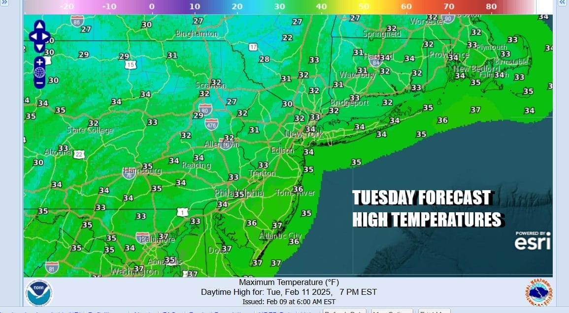
For now we will see sunshine giving way to increasing clouds Tuesday with most highs in the low to middle 30s. If this system makes it far enough north, we could see a period of snow Tuesday night into Wednesday morning with the highest chances in New Jersey south of Interstate 195. We will of course see where models take us later today. Two other storms are on the table. Wednesday night into early Thursday low pressure heading to Western NY will bring some snow ice and rain Wednesday night into early Thursday. Models are also indicating another storm for the President’s Day holiday weekend with possibly more snow ice and rain in the cards. The overall pattern suggests that winter has a long way to go yet.
BE SURE TO DOWNLOAD THE FREE METEOROLOGIST JOE CIOFFI WEATHER APP &
ANGRY BEN’S FREE WEATHER APP “THE ANGRY WEATHERMAN!
MANY THANKS TO TROPICAL TIDBITS FOR THE USE OF MAPS
Please note that with regards to any severe weather, tropical storms, or hurricanes, should a storm be threatening, please consult your local National Weather Service office or your local government officials about what action you should be taking to protect life and property.