
Offshore Low Further East Means Not Quite
Gloom & Doom Weather Next Few Days

Offshore Low Further East Means Not Quite
Gloom & Doom Weather Next Few Days
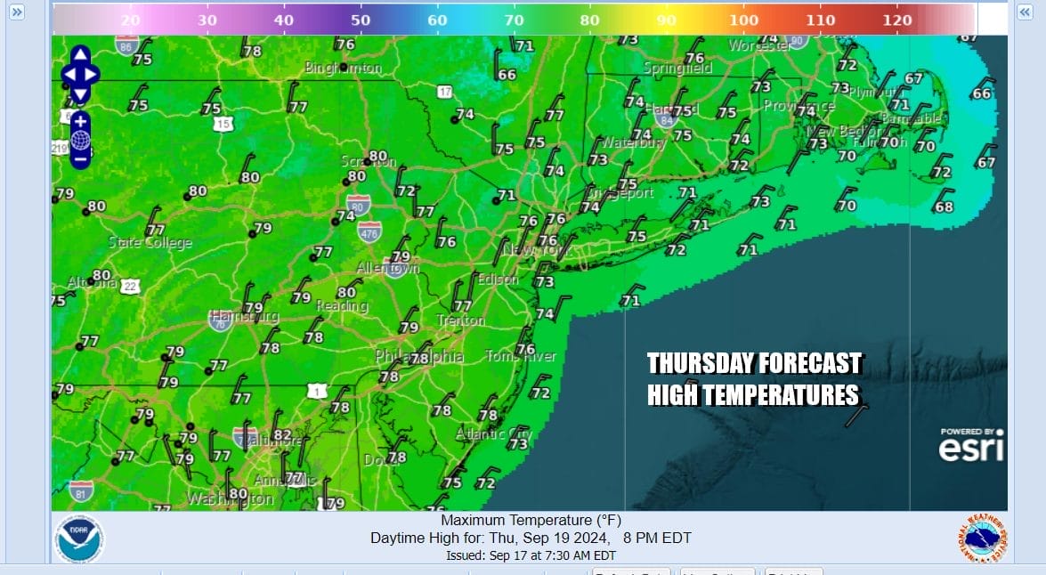
Low pressure is sitting offshore to the east of New Jersey and is just lingering around. However the low is further east and that actually has helped to drain some drier air southward from Eastern Canada. The result will be less gloom and doom and more in the way of sunshine if you are inland and west of NYC. To the east across Southern and Southeastern New England clouds will likely be an issue today. Rain on the radar remains to the east offshore though some of the rain is touching Southeasternmost New England. We will call it cloudy to partly sunny from east to west today. High temperatures to day will be in the 70s in most places except 60s along the coast.
SATELLITE WITH LIGHTNING STRIKES

WEATHER RADAR

The low being further offshore means that rain probably stays away for most areas but it does appear that a disturbance dropping southward from the Eastern Great Lakes will being some showers southward through Pennsylvania and points southward Saturday night and Sunday. We will probably have cloud issues tonight into Saturday in most places but rain will be minimal if any at all fpr ares between the two systems..

The coastal low will being to drift southward Saturday and by Sunday it should be far enough south to allow for general improvement to spread southward from New England. Strong high pressure in Eastern Canada will nose its way southward down the coast bringing drier air into the Northeast and Northern Mid Atlantic states.
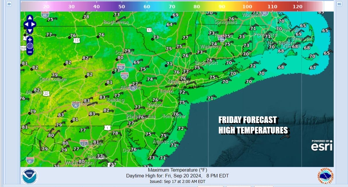
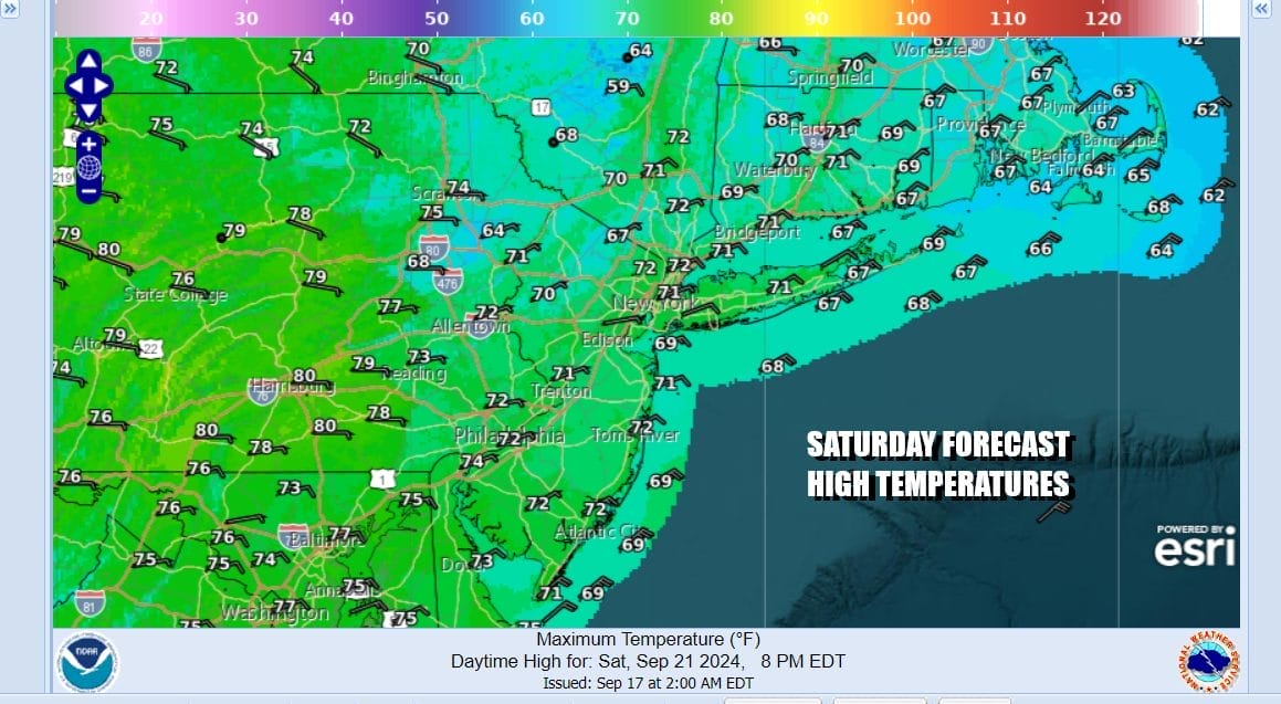
Tonight we will see low clouds coming in from off the ocean with temperatures in the upper 50s to mid 60s. Friday will likely be no worse than cloudy with some areas experiencing partly sunny conditions. Highs will be in the low to mid 70s with 60s to near 70 along the shore. Saturday we will also go cloudy to partly sunny with most highs in the upper 60s coast and low to mid 70s inland.
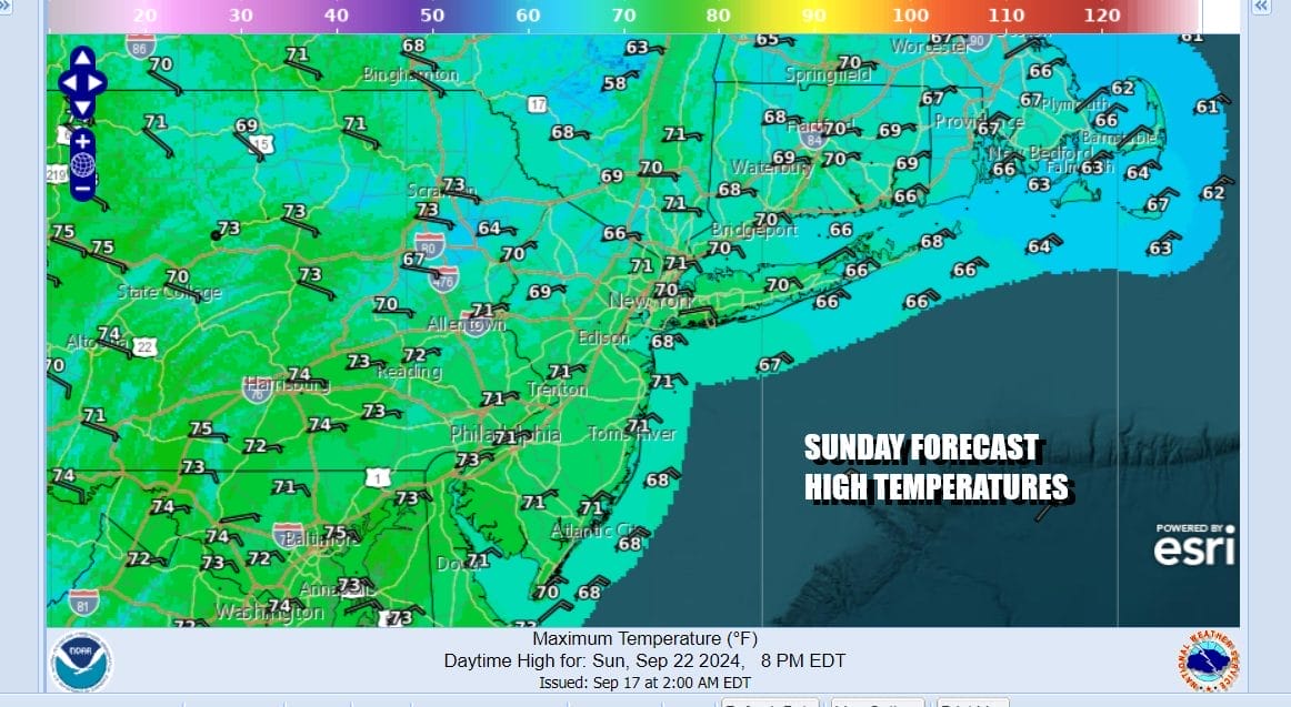
Sunday we will see clouds to start and then decreasing clouds and increasing sun from north to south with high temperatures in the upper 60s and lower 70s. Next week we will see a weather front approach with some showers possible mid week as the blocking pattern in the Eastern US breaks down and the flow across the US normalizes to more of a west to east pattern allowing weather systems to move along with more regularity. The tropics are looking to wake up as a tropical depression or a tropical storm is likely to form in the Northwest Caribbean or the Gulf of Mexico but whether this system has an impact on the Eastern US is highly speculative at this early stage.
BE SURE TO DOWNLOAD THE FREE METEOROLOGIST JOE CIOFFI WEATHER APP &
ANGRY BEN’S FREE WEATHER APP “THE ANGRY WEATHERMAN!
MANY THANKS TO TROPICAL TIDBITS FOR THE USE OF MAPS
Please note that with regards to any severe weather, tropical storms, or hurricanes, should a storm be threatening, please consult your local National Weather Service office or your local government officials about what action you should be taking to protect life and property.
(Amazon is an affilate of Meteorologist Joe Cioffi & earns commissions on sales.)


