

USE THE COUPON CODE “SPRING2026” AND GET 10 PERCENT OFF ON ANY PURCHASE

Ocean Wind Keeps Temps In Check Until Thursday
As Heat Returns Friday
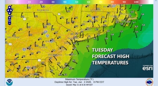
Weather conditions are quiet and rather cool across the Northeast and Northern Mid Atlantic states. Temperatures bottomed this morning in the 40s in many inland locations with lows close to 50 in warmer urban areas. We are going to be on the cool side of normal today with a good deal of sunshine and nothing more than some passing clouds. Temperatures this afternoon will top out in the low to mid 70s as the east wind keeps things cool just about everywhere. Radars are nice and quiet and we don’t expect any rain right through the remainder of the work week.
SATELLITE WITH LIGHTNING STRIKES

WEATHER RADAR

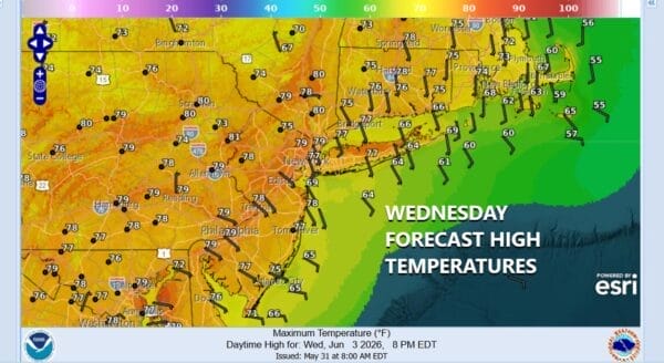
Tonight we are looking at clear skies and it will not be quite as cool as it was this morning. Lows Wednesday morning will be in the 50s except for some of the coolest spots inland where we will see 40s. Wednesday dayside will be a sunny day and it will turn a little warmer with most highs in the upper 70s to around 80 degrees except a little cooler along south and east facing shorelines.
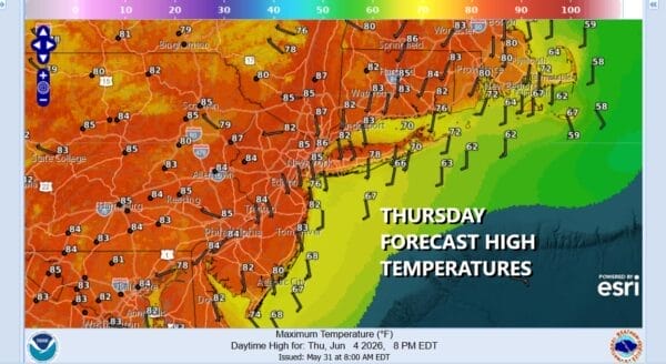
Thursday we will see the high in the Southeast US so winds will turn southwest and that means temperatures will rise. Skies will be partly to mostly sunny Thursday with highs reaching the middle to upper 80s in most places, a little cooler at the shore. There could be the odd 90 degree high in hot spots as usual. Friday will be hot with sunny skies and temperatures will definitely reach into the 90s in most places. Again cooler along south and east facing shorelines.
Over the weekend a cold front will approach Saturday so ahead of that we will have hot and humid conditions with sunshine and highs into the 90s. Late in the day a cold front dropping southward from Upstate New York will set off some thunderstorms. The front is likely to be a very slow mover so, if that is the case, we could see showers and thunderstorms overnight Saturday and for a good part of Sunday. After that the front will sink southward and it will turn cooler and drier for the first part of next week.
DOWNLOAD THE UPSIDE APP & EARN CASH AT GAS STATIONS, RESTAURANTS, & SUPERMARKETS

BE SURE TO DOWNLOAD THE FREE METEOROLOGIST JOE CIOFFI WEATHER APP &
ANGRY BEN’S FREE WEATHER APP “THE ANGRY WEATHERMAN!
MANY THANKS TO TROPICAL TIDBITS FOR THE USE OF MAPS
Please note that with regards to any severe weather, tropical storms, or hurricanes, should a storm be threatening, please consult your local National Weather Service office or your local government officials about what action you should be taking to protect life and property.


