
Noreaster Continues Heavy Rain Coastal Flooding
Noreaster Continues Heavy Rain Coastal Flooding
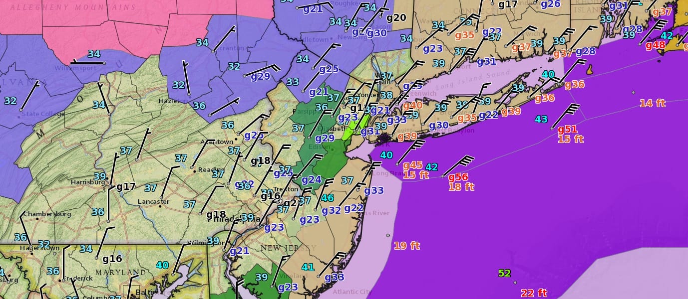
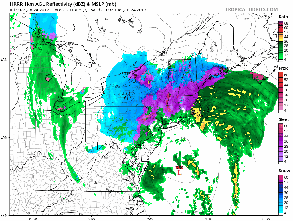
The moderately strong noreaster continues to batter areas of the northeast tonight with heavy rains and strong winds. From the standpoint of winds they have eased somewhat though they continue to be rather strong across Central and Eastern areas of Long Island. Heavy rains from the southeast have brought some much needed drought relief with 2 inches or more in many locations from New Jersey to Southern New England. Sleet is accumulating in inland areas north and northwest of the coast but that should ease somewhat as warmer air pushes northward. The satellite loop shows the well defined low center as it heads northward to just east of the New Jersey coast during Tuesday morning.
SATELLITE LOOP

REGIONAL RADAR

LOCAL RADAR NEW YORK CITY

LOCAL RADAR PHILADELPHIA


Radars continue to show rain moving and rotating northwest from off the ocean with bands of heavy rain still to work through in some areas. During the morning hours the rain will ease somewhat but weather models show more rain is possible during the day Tuesday. Winds will slowly subside during Tuesday.
Coastal flooding is possible during the morning high tides in New Jersey and Long Island with tides 2 to 3 feet above normal so another round of moderate coastal flooding is likely. Sunshine should be back on Wednesday before the next cold front with showers arrives on Thursday.
SNOW REMOVAL COMPANIES FOR YOUR WINTER NEEDS
LONG ISLAND ROCKLAND COUNTY Connecticut

![]()

ROCKLAND COUNTY TRI STATE SNOW REMOVAL JOHNSTOWN PA


FiOS1 News Weather Forecast For Long Island
FiOS1 News Weather Forecast For New Jersey
FiOS1 News Weather Forecast For Hudson Valley
NATIONAL WEATHER SERVICE SNOW FORECASTS
LATEST JOESTRADAMUS ON THE LONG RANGE
Weather App

Don’t be without Meteorologist Joe Cioffi’s weather app. It is really a meteorologist app because you get my forecasts and my analysis and not some automated computer generated forecast based on the GFS model. This is why your app forecast changes every 6 hours. It is model driven with no human input at all. It gives you an icon, a temperature and no insight whatsoever.
It is a complete weather app to suit your forecast needs. All the weather information you need is right on your phone. Android or I-phone, use it to keep track of all the latest weather information and forecasts. This weather app is also free of advertising so you don’t have to worry about security issues with your device. An accurate forecast and no worries that your device is being compromised.
Use it in conjunction with my website and my facebook and twitter and you have complete weather coverage of all the latest weather and the long range outlook. The website has been redone and upgraded. Its easy to use and everything is archived so you can see how well Joe does or doesn’t do when it comes to forecasts and outlooks.
Just click on the google play button or the apple store button on the sidebar for my app which is on My Weather Concierge. Download the app for free. Subscribe to my forecasts on an ad free environment for just 99 cents a month.
Get my forecasts in the palm of your hand for less than the cost of a cup of Joe!