Nice Weather Weekend Tropical Depression or Tropical Storm
Could Form Off Southeast US Coast Next Week

Nice Weather Weekend Tropical Depression or Tropical Storm
Could Form Off Southeast US Coast Next Week

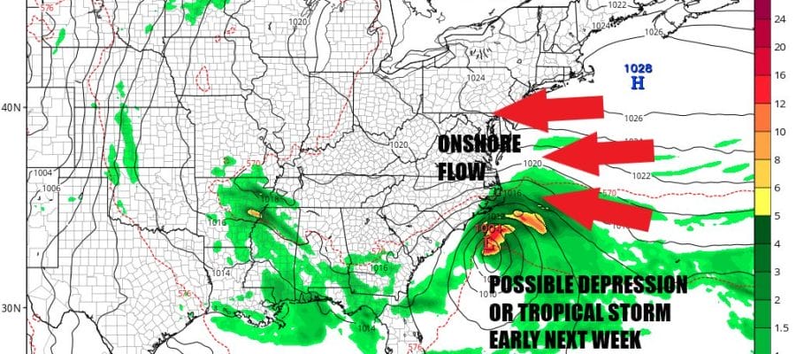
The weekend is here and we see no important changes in the pattern. Blocking high pressure to trh north and northeast remains in place and is not expected to do very much in the meantime other than turn the flow more onshore with time as we head into next week. We also note that there are lower than normal pressures off the Southeast US coast thanks to the high to the north. Low pressure has already formed there. We will have more on this in a moment.

Today there are obviously no issues. We see the satellite mostly free of clouds other than some patchy morning low clouds and some patchy dense fog that are typical in September thanks to long nights and a stable air mass. Skies will be mostly sunny today. There has been a bit of a haze over the last few days due to some wildfire smoke from Western US wildfires as well as some Canada wildfires so that probably continues though I do not see any air quality alerts. High temperatures today will be in the 70s along the coast and lower 80s inland.
SATELLITE WITH LIGHTNING STRIKES

WEATHER RADAR

Radars are nice and quiet up and down the Northeast and Mid Atlantic and we do not expect that to change. Skies will start clear tonight with low clouds and patchy dense fog develop. Overnight lows will be in the 50s inland and low to mid 60s coast. Sunday will be another day of mainly sunny skies with highs in the upper 70s and lower 80s with a wind from off the ocean keeping the coast cooler.

On to next week and Monday will be just a continuation of the weekend with low clouds and patchy fog giving way to mainly sunny skies and highs in the upper 70s and lower 80s, though that process may take a bit longer as the high moves further offshore and more low level moisture comes in. Dew points will be coming up up temperatures will remain in the 70s to near 80 degrees for highs.
s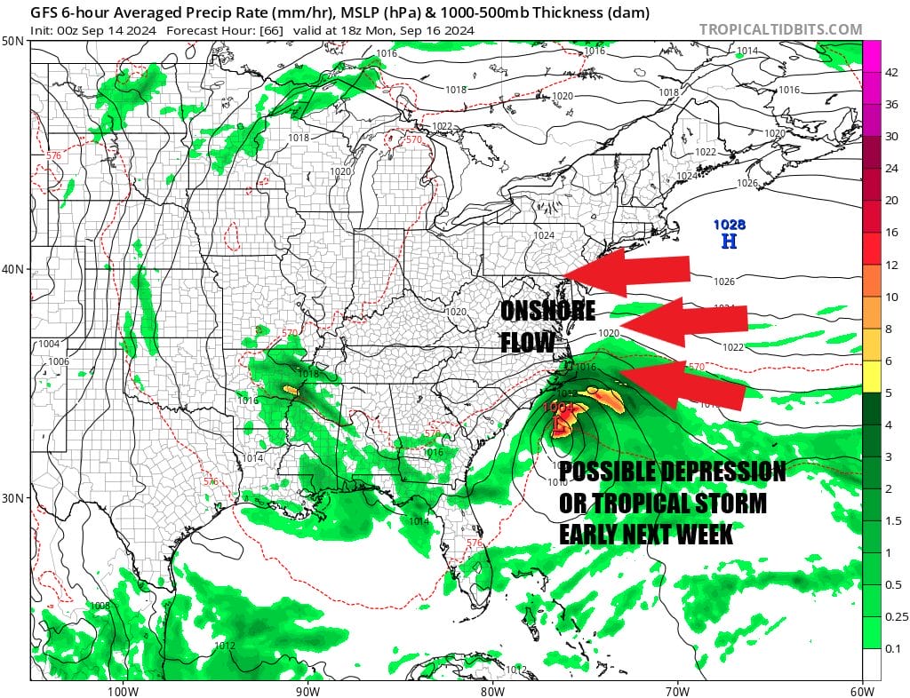 Lower than normal pressures set the stage for a developing low off the Southeast US coast to strengthen and become a tropical depression or a tropical storm. While all the global weather models show this happening, it is not necessarily a guarantee at this point. The low could remain weak or form closer to the coast limiting development. Then there is the process of a system going non tropical to tropical which can sometimes take days to occur. Models seem to grasping to the idea of faster development during the day Monday before moving inland in Coastal South or North Carolina Monday night or early Tuesday. Rain from this could spread northward though the dayside Tuesday for Eastern Pennsylvania to Southern New England should be dry Tuesday with highs in the 70s and increasing cloud cover. Rain could be an issue Tuesday night and Wednesday depending on timing and track. This will be a system that will be on our personal radar for the weekend and early next week. Right now the National Hurricane Center as of early Saturday morning is forecasting a 50 percent chance this develops into a tropical depression or a tropical storm. Either way it does seem some rain is in the offing from the Carolinas to Southern New England next week.
BE SURE TO DOWNLOAD THE FREE METEOROLOGIST JOE CIOFFI WEATHER APP &
ANGRY BEN’S FREE WEATHER APP “THE ANGRY WEATHERMAN!
MANY THANKS TO TROPICAL TIDBITS FOR THE USE OF MAPS
Please note that with regards to any severe weather, tropical storms, or hurricanes, should a storm be threatening, please consult your local National Weather Service office or your local government officials about what action you should be taking to protect life and property.
(Amazon is an affilate of Meteorologist Joe Cioffi & earns commissions on sales.)


