
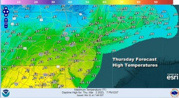
Next Storm To Bring Mostly Rain With Snow Well to the North Weekend Outlook
We have a weather front moving through today that produced some showers overnight and this morning but that front will be passing offshore and that should allow some improvement this afternoon. Since we started out on the warm side, once we see some sunshine breaking through the clouds, it should take temperatures into the mid 50s to some lower 60s to the south. Then tonight as skies briefly clear out, we will see temperatures drop to the mid to upper 20s inland and low to mid 30s along the coast.
SATELLITE

WEATHER RADAR

On to Friday where we have the next storm system that is now coming out of the lower Mississippi Valley and heading for the upper Ohio Valley. This is the primary low which will track toward Western Pennsylvania and weaken while a secondary low develops off the New Jersey coast and becomes the main system Friday night into Saturday. While this set up is almost the same as our snow producer Monday, the stronger primary, and a little less cold air around means that for much of the area this will be primarily a rain event.

Rain will overspread the area Friday from south to north. We could see this start off as some snow or sleet inland mainly north of Route 80 in New Jersey and north of Route 287 in Southern NY. The snow will be brief and then change to rain rather quickly with little consequence. Accumulating snow will be more likely north of Route 84 with the heaviest snows along and north of the I-90 corridor from Upstate NY across into Massachusetts.
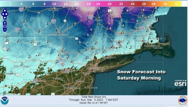
We will see rain into Friday night. North of Route 84 snow to rain and the same for Connecticut where it will be mostly north of Route 84 there. The secondary storm will take over and the rain should come to an end early Saturday morning. Rainfall amounts will be in the order of about 3/4 inch to 1.25 inches.
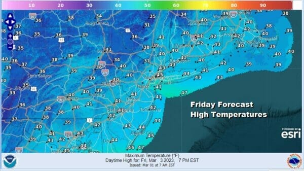
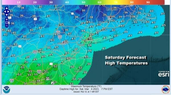
Friday highs will be in the 40s with mid to upper 30s inland. Saturday we will likely see a lot of leftover clouds around and in Connecticut there could be a little snow on the backside which doesn’t amount to much. Temperatures Saturday will be on raw side with highs in the 40s except well inland where highs will likely be in the upper 30s.
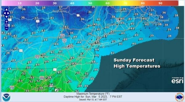
Sunday should be the better of the two weekend days with some sunshine developing Highs will be mostly in the 40s which is about where we should be for this time of year. There are a couple of weak weather systems in the flow that will be running around Sunday but we don’t see any issues other than some patchy clouds from time to time.
Next week the trend will be a colder pattern developing in the Eastern US as a block builds over Greenland and low pressure strengthens well to the east. A system from the Great Lakes will be diving southeastward and move through Tuesday and there could be a little rain or snow with that before the colder air settles in for the second half of next week.
BE SURE TO DOWNLOAD THE FREE METEOROLOGIST JOE CIOFFI WEATHER APP &
ANGRY BEN’S FREE WEATHER APP “THE ANGRY WEATHERMAN!
MANY THANKS TO TROPICAL TIDBITS & F5 WEATHER FOR THE USE OF MAPS
Please note that with regards to any severe weather, tropical storms, or hurricanes, should a storm be threatening, please consult your local National Weather Service office or your local government officials about what action you should be taking to protect life and property.


