
National Weather Service Updated Snowfall Forecasts
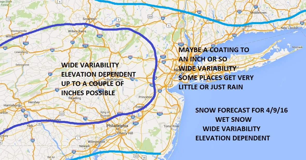
Here is my forecast and below are the National Weather Service Snowfall forecast maps for Saturday’s snow threat. I want to emphasize the high variability that will exist. Some spots will see very little. Roads for the most part will be wet. No travel disruptions are anticipated out of this. Some elevated areas will probably see a few inches of snow. Snow that falls after 5pm might stick to some roads but they should still be fine for the most part. Precipitation begins around mid morning to noontime and should be ending from west to east during the evening hours with Long Island and Coastal New Jersey being the last areas to see precipitation end. Temperatures Saturday night will fall into the 20s so some slick spots will definitely develop Saturday night. Sunday will be dry and cold with sunshine and a few clouds with high temperatures back into the 40s. The forecast hinges on the track of the upper low and where the heaviest precipitation band sets up. It will be a narrow band less than 100 miles wide. Whoever gets under that band will have the best chance for accumulations mainly on colder surfaces. Model forecasts and more analysis.
Joe’s Snowfall Forecast Saturday April 9
National Weather Service Updated Snowfall Forecasts
NEW YORK CITY AND VICINITY SNOW

NEW JERSEY & PARTS OF NE PA

SOUTHERN AND SOUTHEAST NEW ENGLAND

NORTHERN NEW ENGLAND
WESTERN NEW ENGLAND

MIDDLE AND UPPER HUDSON VALLEY
CENTRAL NEW YORK & NE PA

WESTERN NEW YORK

CENTRAL & SOUTH CENTRAL PA

VIRGINIA & MARYLAND

DAILY NORTHEAST SNOWFALL


