Mother’s Day of Nice Weather Week Ahead Looks Mostly Dry

Mother’s Day of Nice Weather Week Ahead Looks Mostly Dry
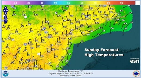
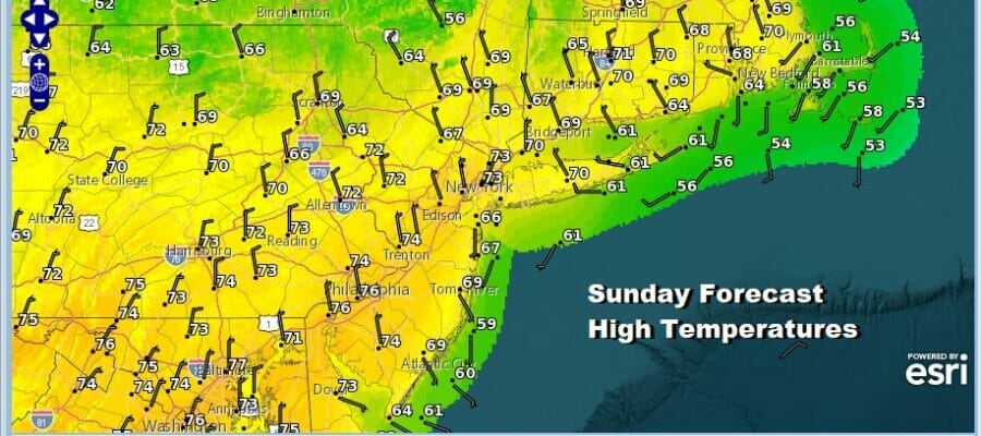
The last 2 years have not been kind weather wise on Mother’s Day but they can’t always be bad weather days and today will be a good one across the Northeast and Northern Mid Atlantic states. The northwest flow continues to stream down some patchy cloudiness so it really shouldn’t be any worse than partly sunny today. There will be a nice dry northerly breeze that may go northeast during the course of the day. Nothing rain wise is showing up on the local and regional radars. Therefore enjoy the day with highs in the upper 60s and lower 70s.
SATELLITE

WEATHER RADAR

The week ahead will be mostly a quiet one with air masses coming and going in the northwest flow. Rain wise it looks to be mostly dry through Friday however we do have a cold front that will be dropping southeastward from Eastern Canada Tuesday and moving through the area Tuesday night into early Wednesday.

There isn’t much moisture with the front as it drops through form the north. There is some moisture that comes out of the Ohio Valley and moves east with some showers. Those will pass to the south. So right now other than a shower or two the front should pass through with little fanfare.
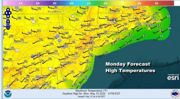
Tonight should be nice and clear. Most lows will be in the mid 40s to lower 50s. Monday should be a nice day of sinshine. Winds will turn to the southwest so that will nudge temperatures higher, reaching the low and middle 70s in most places. It will be a little cooler along south and east facing shorelines.
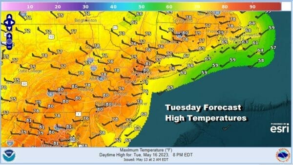
Tuesday we will see the wind turn to the west as the cold front drops southward from Upstate NY and New England. The dew points are on the low side, and there isn’t much moisture so lets call it mostly sunny to start and perhaps partly sunny later in the day. Highs will reach into the 80s and there could be a little upside here to these forecast amounts.
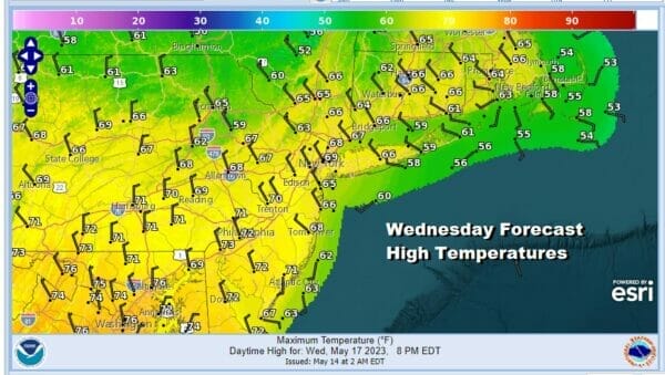
Another air mass comes down from Canada and into the Eastern US leaving us dry with cooler temperatures Wednesday. We will have sunny but cooler day with most highs in the upper 60s and lower 70s. The pattern shifts a bit for the end of the week as the GFS and other models show the high moving offshore. Weather systems will start moving from west to east again. Thursday looks to be a day of sunshine but winds for Thursday and Friday will turn more southeast and south rather than southwest which will limit warming. Thursday highs will be into the 70s and Friday highs could be a little higher in the mid to upper 70s. Cooler temperatures will occur along south and east facing shorelines. Next weekend brings a cold front and an increasing chance for showers and possible thunderstorms.
BE SURE TO DOWNLOAD THE FREE METEOROLOGIST JOE CIOFFI WEATHER APP &
ANGRY BEN’S FREE WEATHER APP “THE ANGRY WEATHERMAN!
MANY THANKS TO TROPICAL TIDBITS & F5 WEATHER FOR THE USE OF MAPS
Please note that with regards to any severe weather, tropical storms, or hurricanes, should a storm be threatening, please consult your local National Weather Service office or your local government officials about what action you should be taking to protect life and property.
(Amazon is an affilate of Meteorologist Joe Cioffi & earns commissions on sales.)


