
Mostly Chilly Week Ahead Next Storm System Saturday
As Low Moves Up The Coast Offshore

Mostly Chilly Week Ahead Next Storm System Saturday
As Low Moves Up The Coast Offshore
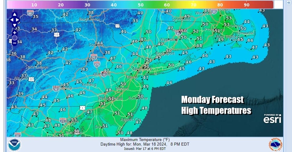
This Monday sees a weak low offshore that is moving away to the east. This is producing some clouds but not much else. Today is the last full day of winter as the sun cross the equator Tuesday for the Vernal Equinox or the arrival of the spring season. Of course after a winter where colder than average temperatures only happened on a handful of days, we now go into a colder than average temperature pattern across much of the Eastern and Southern US.

Today will be a day of a mix of clouds and sun. Highs will be in the lower 50s. We do see moisture coming off the Great Lakes and this is producing some lake effect snows in Upstate NY and NW Pennsylvania but for the most part the issues are minimal. Tonight across the eastern half of the US it will be cold. Many areas across the Deep South could see lows in the 20s and lower 30s creating freezes at a time when the growing season has gotten or is about to get underway. In Eastern Pennsylvania to Southern New England, inland lows will be in the upper 20s and most lows for coast and warmer urban locations will be in the 30s.
SATELLITE WITH LIGHTNING STRIKES

WEATHER RADAR

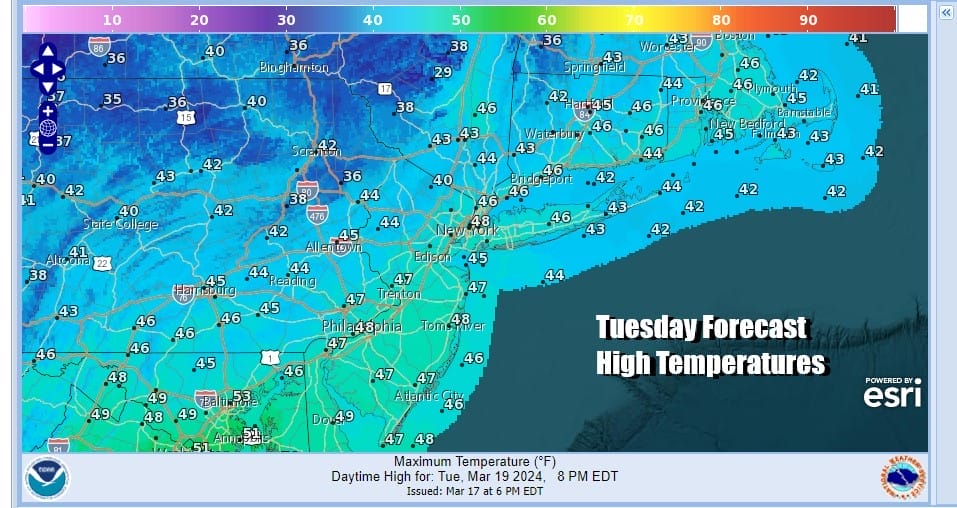
Tuesday will be a chilly day with some sunshine and a few clouds with highs just in the middle to upper 40s which is about 3 to 6 degrees below average depending on your location. There will be wind issues to deal with both today and Tuesday as we have a somewhat tight pressure gradient so winds will be gusts of 20 to occasionally 30 mph at times both today and Tuesday across the Northeast and Mid Atlantic states.
Wednesday we have a cold front approaching and a west wind ahead of it plus sunshine should take highs into the 50s. The front will pass and that sets up for a colder Thursday and Friday with highs in the 40s and some sunshine both days. Attention then turns to low pressure that develops in the Western Gulf of Mexico while at the same time another cold front moves southeast from the Western Great Lakes and into the Eastern US.

Rain will be moving across the Gulf States Thursday and Friday and then up the East Coast later Friday into at least part of Saturday. The low track looks to be just offshore but there is a chance that the northern part of the jet stream could suppress this to the south and east. For now we now that other than some sort of stray shower or snow shower, the work week is dry through Friday. This system is nothing major as it will play through, followed by another shot of colder than average temperatures into the Eastern US for early next week.
BE SURE TO DOWNLOAD THE FREE METEOROLOGIST JOE CIOFFI WEATHER APP &
ANGRY BEN’S FREE WEATHER APP “THE ANGRY WEATHERMAN!
MANY THANKS TO TROPICAL TIDBITS FOR THE USE OF MAPS
Please note that with regards to any severe weather, tropical storms, or hurricanes, should a storm be threatening, please consult your local National Weather Service office or your local government officials about what action you should be taking to protect life and property.
(Amazon is an affilate of Meteorologist Joe Cioffi & earns commissions on sales.)


