Mid September Weather Next 4 Days Low Humidity Sunshine Today
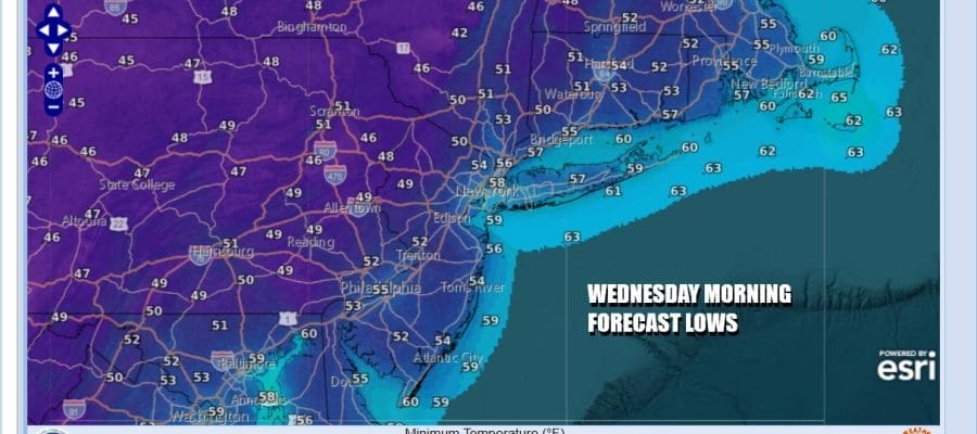
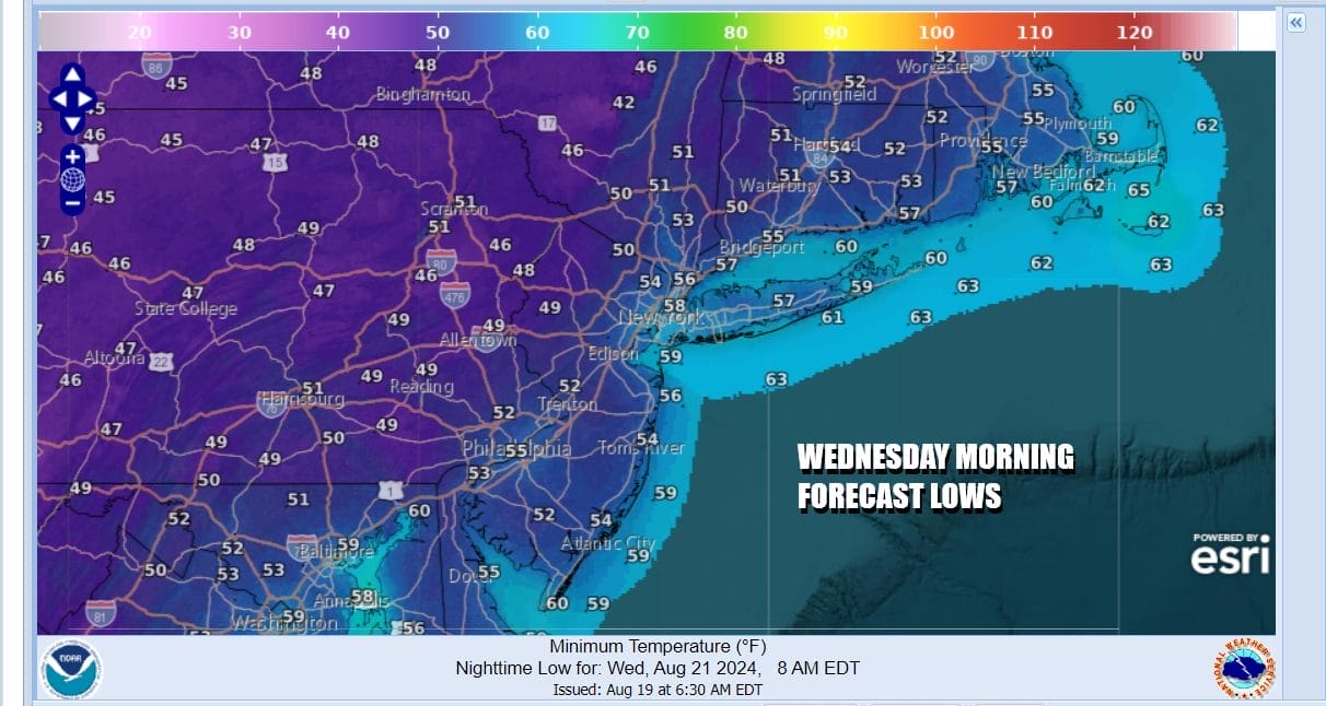
Cool Night Into Wednesday Morning

Mid September Weather Next 4 Days Low Humidity Sunshine Today
Cool Night Into Wednesday Morning

Finally the cold front passed offshore last night and in came the “woosh” of dry cooler air. We are going to see a stretch of days of temperatures that are more like Mid September than Mid August. A deep upper trough is Eastern Canada is funneling cool dry air southward and a large surface high over the Great Lakes will take over for the next 4 days. We will see sunshine today with passing clouds. Dew points will be down in the upper 40s and lower 50s and temperatures this afternoon will be in the low to middle 70s. At least we can put the torrential rains of the weekend behind us.
SATELLITE WITH LIGHTNING STRIKES

WEATHER RADAR

The upper trough will strengthen tonight as an upper low moves southward into New York State. Skies overnight should be clear and this will bring cool air everywhere even to the usually warmer urban locations. Most lows Wednesday morning will be in the 50s just about everywhere making this the coolest morning we have seen since June.
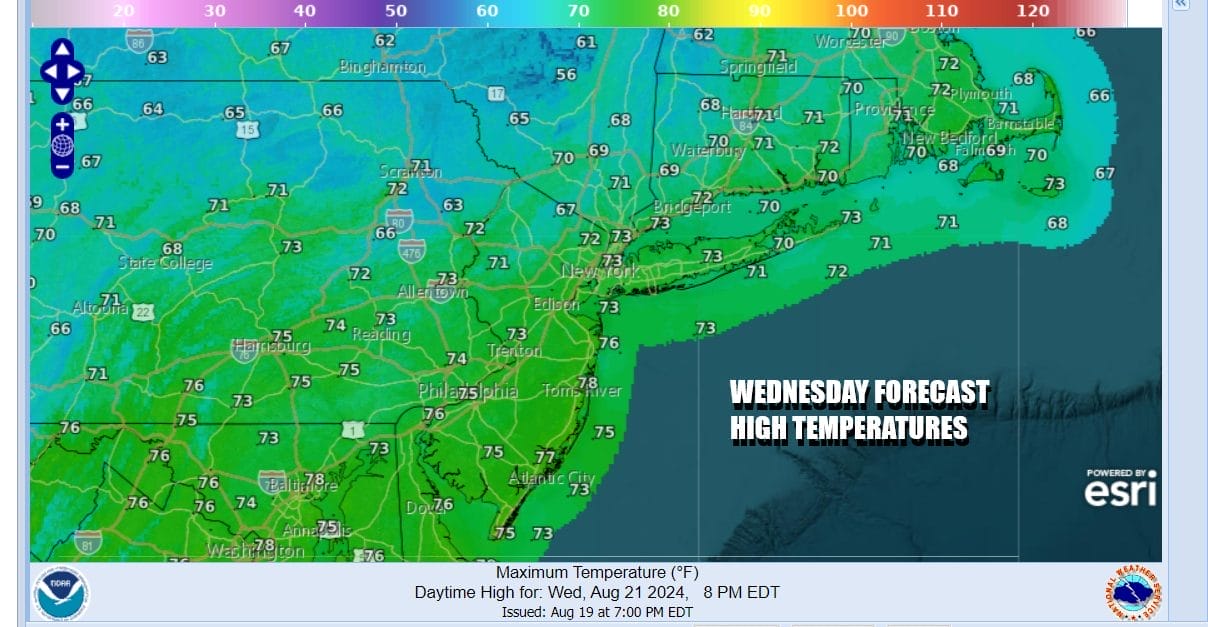
The upper low over the Northeast will create a somewhat unstable atmosphere so while the day starts with sun, it will probably self destruct with clouds developing. Some scattered instability showers are possible but the best chances will be inland and they will in no way resemble the downpours of the weekend. It will however be quite cool. Depending on the cloud cover, inland highs may have a tough time getting out of the 60s while the warmer spots might make it to the lower 70s.
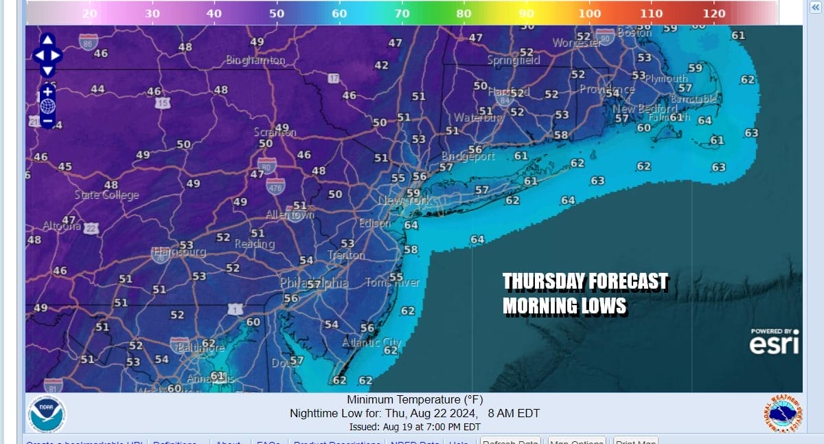
The upper low pulls away Wednesday night leaving the coolest air of this air mass overhead. Thursday morning lows will be in the 50s everywhere and inland where winds successfully drop off we could see some cold spots north and northwest of the coast bottoming out in the 40s!
Thursday should be partly to mostly sunny with a more stable atmosphere. Highs will be in the low to mid 70s. Friday look for temperatures to start moving higher as the high begins to settle to our south. Dew points however will remain low so the humidity will not be rising. Highs Friday will be in the mid 70s to around 80 degrees.

The surface high being offshore and to our south will allow temperatures to warm up over the weekend. Humidity levels will start to rise but they won’t be rising to tropical levels. The weekend also looks to be dry with at least some sunshine for both Saturday and Sunday. Saturday highs will be in the low to middle 80s. Sunday highs will be in the mid to upper 80s. Next Monday we could see temperatures make a run for 90 degrees in some places. The next weather front with any chance for showers or thunderstorms could come along next Tuesday. Enjoy the mid September temperatures and especially the cool nights!
BE SURE TO DOWNLOAD THE FREE METEOROLOGIST JOE CIOFFI WEATHER APP &
ANGRY BEN’S FREE WEATHER APP “THE ANGRY WEATHERMAN!
MANY THANKS TO TROPICAL TIDBITS FOR THE USE OF MAPS
Please note that with regards to any severe weather, tropical storms, or hurricanes, should a storm be threatening, please consult your local National Weather Service office or your local government officials about what action you should be taking to protect life and property.
(Amazon is an affilate of Meteorologist Joe Cioffi & earns commissions on sales.)


