Memorial Day Rain

MENTION JOE CIOFFI AND GET A 5% DISCOUNT
Sunday Looks Good Memorial Day Rain
Midweek Weather Model Questions
With the arrival of Tropical Depression 2 to the South Carolina coast, weather models are having some differences in how to handle the tropical moisture going forward. First there is the issue of the actual surface center which weather models are leaving behind along or just offshore. Then there is the issue of the tropical moisture and the rain as a cold front approaches from the northwest and what that does.
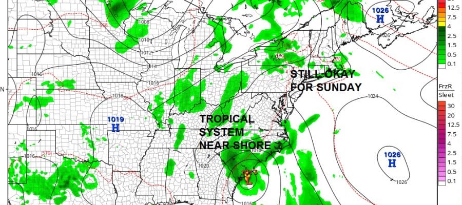
STILL GOOD FOR SUNDAY MEMORIAL DAY RAIN GFS SURFACE SUNDAY MORNING

Before we address Monday Memorial day we can say that other than a pop up shower or thunderstorm this evening inland, our weather will be fine into Sunday evening. Just a few clouds around tonight with lows in the 60s tonightand no worse than partly sunny skies Sunday dayside with highs in the 80s to near 90 inland and 70s to near 80 along south facing shores.
Memorial Day Rain GFS MODEL MONDAY AFTERNOON
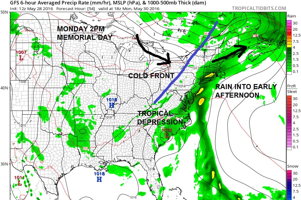
Now for Sunday night and Monday. We have the tropical system on the coast and moisture getting fanned northeastward and enhanced by the approaching front from the west. Weather models are slowing down with every run which put Monday afternoon now into question. In fact the European model and the NAM model want to bring up the remnant low to some degree and actually the European has rain into Southern New Jersey on Tuesday. The problem in these weak steering environments is trying to figure out what happens after upper air steering winds collapse. The GFS and European would take the next night to the north and create an onshore flow again for the middle of next week.
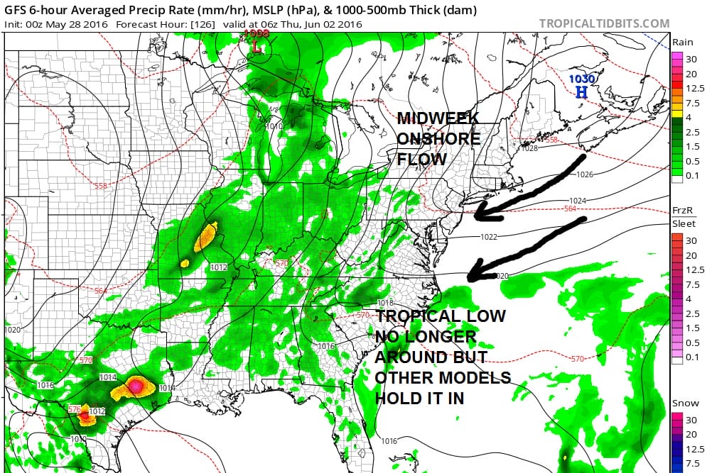
Memorial Day Rain Midweek Questions
GFS VS EURO MODEL THURSDAY
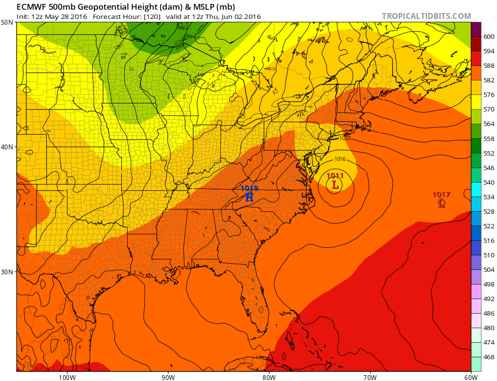
Now I would caution Euro weather model lovers that the Euro has not been good lately in a number of ways…including overplaying coastal lows over the last few weeks. So I would take its view with a huge grain of salt at this point. For now I think the idea of rain from later Sunday night into early Monday afternoon and then drier and cooler for Tuesday and beyond is the way to go at this point. With rain into Monday afternoon, temperatures will be in the low to mid 70s for highs.
FiOS1 News Weather Forecast For Long Island
FiOS1 News Weather Forecast For New Jersey
FiOS1 News Weather Forecast For Hudson Valley
NATIONAL WEATHER SERVICE SNOW FORECASTS
LATEST JOESTRADAMUS ON THE LONG RANGE

NOMINATED FOR AN APPY AWARD FOR BEST WEATHER APP!!
Weather App

Don’t be without Meteorologist Joe Cioffi’s weather app. It is really a meteorologist app because you get my forecasts and my analysis and not some automated computer generated forecast based on the GFS model. This is why your app forecast changes every 6 hours. It is model driven with no human input at all. It gives you an icon, a temperature and no insight whatsoever.
It is a complete weather app to suit your forecast needs. All the weather information you need is right on your phone. Android or I-phone, use it to keep track of all the latest weather information and forecasts. This weather app is also free of advertising so you don’t have to worry about security issues with your device. An accurate forecast and no worries that your device is being compromised.
Use it in conjunction with my website and my facebook and twitter and you have complete weather coverage of all the latest weather and the long range outlook. The website has been redone and upgraded. Its easy to use and everything is archived so you can see how well Joe does or doesn’t do when it comes to forecasts and outlooks.
Just click on the google play button or the apple store button on the sidebar for my app which is on My Weather Concierge. Download the app for free. Subscribe to my forecasts on an ad free environment for just 99 cents a month.
Get my forecasts in the palm of your hand for less than the cost of a cup of Joe!
![]()

