
Maria Heading To The Leeward Islands Hurricane Watches Issued
Maria Heading To The Leeward Islands Hurricane Watches Issued
Maria continue to get better organized this evening and the rapidness of the organization continues to impress. The core of the circulation continues to become better defined. There is very little wind shear issues. The atmosphere is very moist at all levels and water temperatures are in the mid to upper 80s. Maria will likely be a hurricane by this time tomorrow night and it will be passing over or near many of the same islands that were destroyed by Irma and glanced by Jose.

The wide satellite view shows Maria in between Jose to the northwest and Lee to the east. Upper air steering will continue to take Maria to the west or slightly north of west. Weather conditions across the Southern Leewards and Northern Windward Islands will likely begin to deteriorate later on Sunday at its current rate of motion.

The water vapor loop shows there is very little dry air around Maria and there are no upper lows near by to create any disruption in the circulation or the development. Don’t be surprised if we see Maria go into a rapid strengthening phase over the next 2 or 3 days.

Beyond the Leewards Puerto Rico & the Domincan Republic stand to be in direct threat from Maria. Most of the track models take Maria over or very very close to both of those islands around the middle of this coming week. Maria could become the season’s 4th major hurricane. To quote the hurricane center which is forecasting Maria to reach category 3 125 mph winds by Tuesday “rapid intensification is a distinct possibility, and it would be no surprise if Maria got significantly stronger than
currently forecast.”
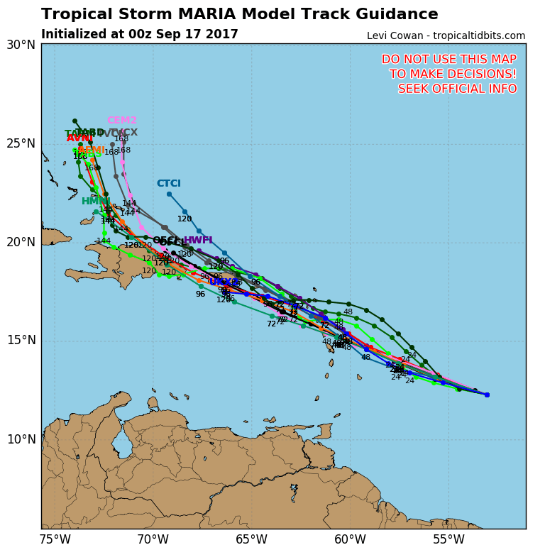
…MARIA MOVING WESTWARD TOWARD THE LESSER ANTILLES…
…NEW HURRICANE WATCHES ISSUED…
SUMMARY OF 1100 PM AST…0300 UTC…INFORMATION
———————————————–
LOCATION…12.5N 53.7W
ABOUT 545 MI…880 KM ESE OF THE LESSER ANTILLES
MAXIMUM SUSTAINED WINDS…50 MPH…85 KM/H
PRESENT MOVEMENT…W OR 280 DEGREES AT 16 MPH…26 KM/H
MINIMUM CENTRAL PRESSURE…1002 MB…29.59 INCHES
WATCHES AND WARNINGS
——————–
CHANGES WITH THIS ADVISORY:
The Government of the Netherlands has issued a Hurricane Watch for
Saba and St. Eustatius.
The Meteorological Service of Curacao has issued a Hurricane Watch
for St. Maarten.
The Meteorological Service of Antigua has issued a Hurricane Watch
for Anguilla.
SUMMARY OF WATCHES AND WARNINGS IN EFFECT:
A Hurricane Watch is in effect for…
* Antigua, Barbuda, St. Kitts, Nevis, and Montserrat
* Guadeloupe
* Saba and St. Eustatius
* St. Maarten
* Anguilla
A Tropical Storm Watch is in effect for…
* St. Lucia
* Martinique
* Dominica
* Barbados
* St. Vincent and the Grenadines
A Hurricane Watch means that hurricane conditions are possible
within the watch area. A watch is typically issued 48 hours
before the anticipated first occurrence of tropical-storm-force
winds, conditions that make outside preparations difficult or
dangerous.
A Tropical Storm Watch means that tropical storm conditions are
possible within the watch area, generally within 48 hours.
Interests elsewhere in the Lesser Antilles and the British and U. S.
Virgin Islands should monitor the progress of this system.
Additional Tropical Storm or Hurricane Watches and Warnings will
likely be issued early Sunday.
For storm information specific to your area, please monitor
products issued by your national meteorological service.
DISCUSSION AND 48-HOUR OUTLOOK
——————————
At 1100 PM AST (0300 UTC), the center of Tropical Storm Maria was
located near latitude 12.5 North, longitude 53.7 West. Maria is
moving toward the west near 16 mph (26 km/h). A turn toward the
west-northwest and a slower forward speed are expected during next
couple of days. On the forecast track, the center of Maria will be
near the Leeward Islands Monday or Monday night.
Maximum sustained winds are near 50 mph (85 km/h) with higher gusts.
Strengthening is expected during the next 48 hours, and Maria is
forecast to be a hurricane when it approaches the Leeward Islands.
Tropical-storm-force winds extend outward up to 45 miles (75 km)
from the center.
The estimated minimum central pressure is 1002 mb (29.59 inches).
HAZARDS AFFECTING LAND
———————-
WIND: Hurricane conditions are possible within the hurricane watch
area by Monday night or Tuesday, with tropical storm conditions
possible on Monday. Tropical storm conditions are possible in the
tropical storm watch area on Monday.
STORM SURGE: A dangerous storm surge accompanied by large and
destructive waves will raise water levels by as much as 3 to 5 feet
above normal tide levels within the hurricane watch area.
RAINFALL: Maria is expected to produce total rain accumulations of 6
to 12 inches with isolated maximum amounts of 20 inches across the
central and southern Leeward Islands through Tuesday night. Maria is
also expected to produce total rain accumulations of 2 to 4 inches
with isolated maximum amounts of 8 inches in the northern Leeward
Islands through Tuesday night. This rainfall could cause
life-threatening flash floods and mudslides.
SURF: Swells generated by Maria are expected to begin affecting the
Lesser Antilles by Sunday night. These swells are likely to cause
life-threatening surf and rip current conditions. Please consult
products from your local weather office.
MANY THANKS TO TROPICAL TIDBITS FOR THE WONDERFUL USE OF THE MAPS
 GET JOE A CIGAR IF YOU LIKE

Weather App

Don’t be without Meteorologist Joe Cioffi’s weather app. It is really a meteorologist app because you get my forecasts and my analysis and not some automated computer generated forecast based on the GFS model. This is why your app forecast changes every 6 hours. It is model driven with no human input at all. It gives you an icon, a temperature and no insight whatsoever.
It is a complete weather app to suit your forecast needs. All the weather information you need is right on your phone. Android or I-phone, use it to keep track of all the latest weather information and forecasts. This weather app is also free of advertising so you don’t have to worry about security issues with your device. An accurate forecast and no worries that your device is being compromised.
Use it in conjunction with my website and my facebook and twitter and you have complete weather coverage of all the latest weather and the long range outlook. The website has been redone and upgraded. Its easy to use and everything is archived so you can see how well Joe does or doesn’t do when it comes to forecasts and outlooks.
Just click on the google play button or the apple store button on the sidebar for my app which is on My Weather Concierge. Download the app for free. Subscribe to my forecasts on an ad free environment for just 99 cents a month.
Get my forecasts in the palm of your hand for less than the cost of a cup of Joe!
SHOP THE JOESTRADAMUS STORE
