JOSE THREAT INCREASES FOR COASTAL NORTHEAST
JOSE THREAT INCREASES FOR COASTAL NORTHEAST
TROPICAL STORM WATCH MAY BE REQUIRED LATER TODAY FOR COASTAL AREAS FROM DELAWARE TO SOUTHEAST NEW ENGLAND
I have to start this by saying I have never seen anything quite like this. The weather model shift last night was something I have never witnessed and never even imagined. I am still trying to comprehend it. Lets begin with what Jose is doing at the moment which is not moving in any big hurry. It has been crawling slowly northward on the satellite loop this morning. This is do to the unusual lack of any kind of defined steering flow along the east coast. Jose instead of being controlled by a trough in the upper atmosphere that would move it along is being pushed along around the western edge of an upper high and a very weak upper air system over the Northeast. This has now set the table for a what could be a long duration tropical storm event for us with rain wind and coastal flooding lasting for several days or even longer.
SATELLITE LOOP

Jose remains a category 1 hurricane with maximum winds of 80 mph and Air Force plane is enroute to investigate.
..JOSE MOVING A LITTLE FASTER NORTHWARD WITH NO CHANGE IN
STRENGTH…
…DANGEROUS SURF AND RIP CURRENTS EXPECTED ALONG THE EAST
COAST OF THE UNITED STATES…
SUMMARY OF 500 AM EDT…0900 UTC…INFORMATION
———————————————-
LOCATION…30.0N 71.7W
ABOUT 420 MI…680 KM SSE OF CAPE HATTERAS NORTH CAROLINA
ABOUT 435 MI…705 KM WSW OF BERMUDA
MAXIMUM SUSTAINED WINDS…80 MPH…130 KM/H
PRESENT MOVEMENT…N OR 360 DEGREES AT 8 MPH…13 KM/H
MINIMUM CENTRAL PRESSURE…973 MB…28.74 INCHES
WATCHES AND WARNINGS
——————–
There are no coastal watches or warnings in effect.
Interests from North Carolina northward to New England on the east
coast of the United States should monitor the progress of this
system. Tropical storm watches may be needed for portions of this
area during the next day or two.
DISCUSSION AND 48-HOUR OUTLOOK
——————————
At 500 AM EDT (0900 UTC), the center of Hurricane Jose was located
near latitude 30.0 North, longitude 71.7 West. Jose is moving
toward the north near 8 mph (13 km/h), and this general motion with
a slight increase in forward speed is expected through early
Tuesday.
Maximum sustained winds are near 80 mph (130 km/h) with higher
gusts. Some fluctuations in intensity are possible over the
next couple of days, but Jose is forecast to remain a hurricane
through early Tuesday.
Hurricane-force winds extend outward up to 45 miles (75 km) from the
center and tropical-storm-force winds extend outward up to 185 miles
(295 km).
The estimated minimum central pressure is 973 mb (28.74 inches).
HAZARDS AFFECTING LAND
———————-
SURF: Swells generated by Jose are affecting Bermuda, the Bahamas,
the northern coasts of Hispaniola and Puerto Rico, and much of the
U.S. east coast. These swells are likely to cause dangerous surf and
rip current conditions for the next several days in these areas.
For more information, please consult products from your local
weather office.
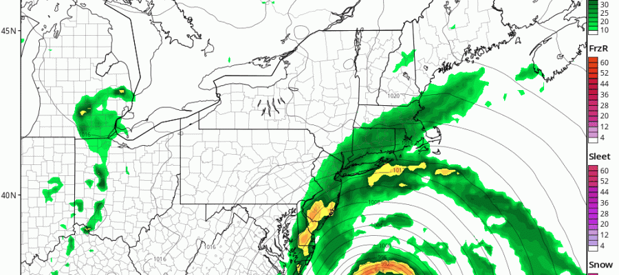
NAM MODEL TUESDAY INTO WEDNESDAY CLICK TO ANIMATE
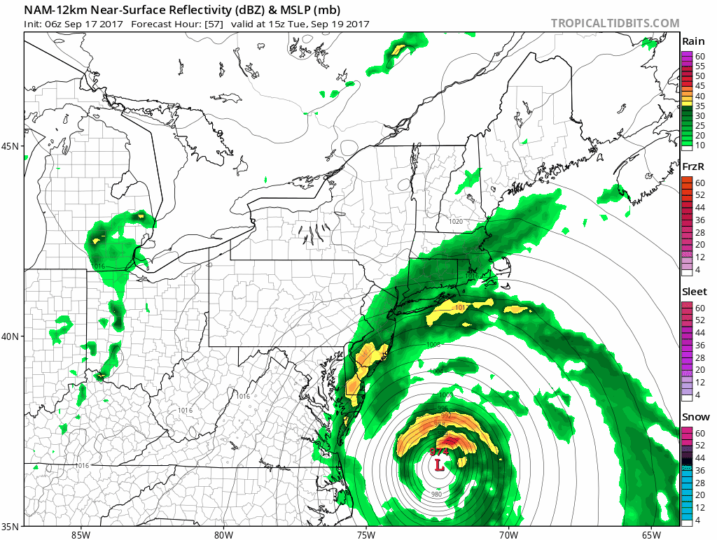
I’m using the NAM surface map to illustrate here as it is very close to what the European model did with this overnight. The upper air feature controlling all this basically misses whatever trough is in the jet stream to the north. Rather than get kicked out the ridge in the east effectively draws it back in to the north. What we wind up with is a slowly deteriorating hurricane that produces a long duration tropical storm event from Delaware to Southeast Eastern New England.
EUROPEAN UPPER AIR FORECAST MONDAY THROUGH FRIDAY
CLICK TO ANIMATE

So what does this all mean for the weather here? Well at least the good news is that we don’t have a hurricane plowing into the coastline in one shot. However we do have what could be a long duration tropical storm event that could produce heavy rain and gales along the coast for several days if these overnight models are correct. The biggest risk will be coastal flooding which will last over several days with increasingly high tides beginning on Tuesday and lasting at least until Thursday. The model change is so radical that I want to wait until later today to see if this the last twist in the forecast or are there other surprises in store.
 GET JOE A CIGAR IF YOU LIKE

FiOS1 News Weather Forecast For Long Island
FiOS1 News Weather Forecast For New Jersey
FiOS1 News Weather Forecast For Hudson Valley
NATIONAL WEATHER SERVICE SNOW FORECASTS
LATEST JOESTRADAMUS ON THE LONG RANGE
SHOP THE JOESTRADAMUS STORE
