Major Winter Storm Threat Increases On GFS
The new dayside run of the GFS model remains pretty much steadfast and on course with its idea. It would argue for 1 foot plus snows for Southern New England South to Virginia for 2 foot snows around the Washington DC Baltimore area. The model run was in some regards a shade further northeast from the prior run but at the same time colder. I have maintained for days that mixing issues would be minimal and confined to coastal Monmouth & Ocean counties southward and only for a short period of time as the model collapses the cold air rapidly after sunrise Saturday morning. I think this is perfectly reasonable given what it shows. It also generates a generous amount of liquid precipitation for much of New Jersey into Southern New England.
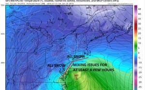
With regards to mixing issues this is the profile of the temperatures at 5000 feet (850mb) which we look at often. The model here on Saturday morning is at its warmest and I have outlined in red where I think the snow mixing/rain line will be at its furthest north position. After this the cold air collapses into the surface low that is developing out in the ocean. This would make total sense to me.
Major Winter Storm Threat Increases On GFS 850 Temps Saturday 7am
The European last night was not that different except that it was a little further south. My overall opinion of this GFS run is that it came in deep and a little further northeast. At some point this low will only get so far north before it begins moving east or east northeast. Let’s see where the European takes us. The NAM model was very similar to the GFS and is also a little north of the European from last night. I don’t want to leave the wrong impression. These models are close to each other. Its that from a forecast standpoint 50 miles could make a huge difference for somebody. At this point a major winter storm is going to happen along the east coast. How it plays out in details, yet to be fully determined.
Side note: A major winter storm threat also means a coastal flooding beach erosion threat and there could be serious coastal flooding and beach erosion from this given that we have a full moon on Saturday. It is not just about snow.
NEW VIDEO ANALYSIS OF AFTERNOON GFS
VIDEO ANALYSIS OF EUROPEAN FROM OVERNIGHT
LATEST EUROPEAN DISCUSSION REGARDING MAJOR STORM THREAT
LATEST GFS DISCUSSION REGARDING MAJOR STORM THREAT
NATIONAL WEATHER SERVICE SNOW FORECASTS
LATEST JOESTRADAMUS ON THE LONG RANGE
Weather App
Winter is here! Don’t be without Meteorologist Joe Cioffi’s weather app. It is a complete weather app to suit your forecast needs. All the weather information you need is right on your phone. Android or I-phone, use it to keep track of all the latest weather information and forecasts. This weather app is also free of advertising so you don’t have to worry about security issues with your device. An accurate forecast and no worries that your device is being compromised.
Use it in conjunction with my website and my facebook and twitterand you have complete weather coverage of all the latest weather and the long range outlook. The website has been redone and upgraded. Its easy to use and everything is archived so you can see how well Joe does or doesn’t do when it comes to forecasts and outlooks.
Just click on the google play button or the apple store button on the sidebar for my app which is onMy Weather Concierge. Download the app for free. Subscribe to my forecasts on an ad free environment for just 99 cents a month.
Get my forecasts in the palm of your hand for less than the cost of a cup of Joe!


