Major Hurricane Dorian Continues to Strengthen Moving WNW
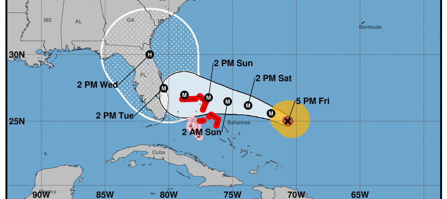
LOCATION…25.0N 70.7W
ABOUT 420 MI…675 KM E OF THE NORTHWESTERN BAHAMAS
ABOUT 595 MI…960 KM E OF WEST PALM BEACH FLORIDA
MAXIMUM SUSTAINED WINDS…115 MPH…185 KM/H
PRESENT MOVEMENT…WNW OR 300 DEGREES AT 9 MPH…15 KM/H
MINIMUM CENTRAL PRESSURE…970 MB…28.65 INCHES
Dorian has been strengthening steadily all day long today with the appearance of what is now a well defined eye. Dorian also seems to be turning more to the west northwest which is following what was suggested by models though it seems to have happened a bit sooner. Dorian is being influenced by the building upper high in the Southwest Atlantic and it will be the driving force of the hurricane’s track for the next several days. The strength of that ridge will be the key to how far west Dorian gets before it exploits a weakness in the upper high that will exist over the Southeast US.
SATELLITE

Dorian is also sandwiched between two upper level lows with one to the west that is moving into the Gulf of Mexico and one to the east. This is creating an ideal outflow scenario over the hurricane. Ocean water temperatures here are in the mid 80s. There really is nothing standing in the way of Dorian becoming at the very least a category 4 hurricane over the weekend.
REGIONAL RADAR

There really is no change in the forecast logic going forward. I’m sure many of you may have heard about the European model turning it northward just to the east of the Florida coast and keeping the eye of the hurricane just offshore. That is certainly a possibility IF the upper high is weak enough. However be very cautious and do not rely on any one model for decision making. Check with your local officials and your local National Weather Service forecast office as well as the National Hurricane center. I can’t emphasize this statement strongly enough.
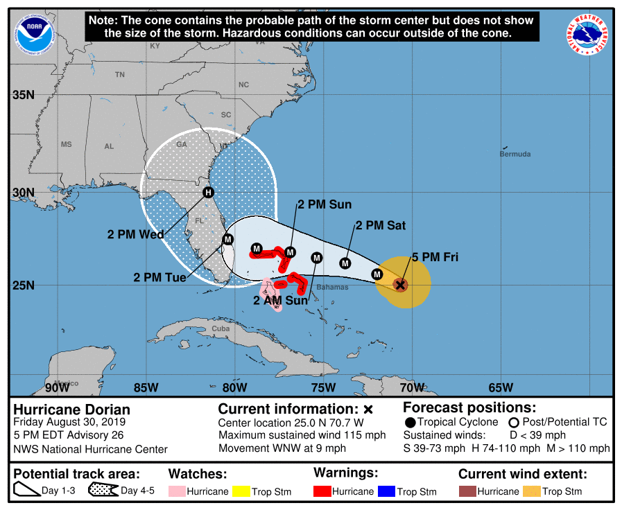
The National Hurricane Center’s official forecast is nudged a little bit to the east but it still showing a landfall along the Florida coast sometime Tuesday early afternoon. The slower motion means that it is too soon for Hurricane Watches to go up for Florida though Hurricane Warnings are now posted for the Northern Bahamas as the map shows.
Additional coverage of Hurricane Dorian continues on my weather platform on Patreon.
MANY THANKS TO TROPICAL TIDBITS FOR THE USE OF MAPS
Please note that with regards to any tropical storms or hurricanes, should a storm be threatening, please consult your local National Weather Service office or your local government officials about what action you should be taking to protect life and property.