Long Island Heat Humidity On The Way This Weekend & Next Week

Weather in 5/Joe & Joe Weather Show Latest Podcast
Long Island Heat Humidity On The Way This Weekend & Next Week
Last night’s low that spun up offshore is now moving away and weakening. Clouds were around all morning but they are now pulling away to the east and sky conditions are improving into this evening. Humidity levels have come up some today but they are still just moderate. That will change starting Saturday. Overnight we will see mainly clear skies with most lows in the mid 60s to around 70.
SATELLITE

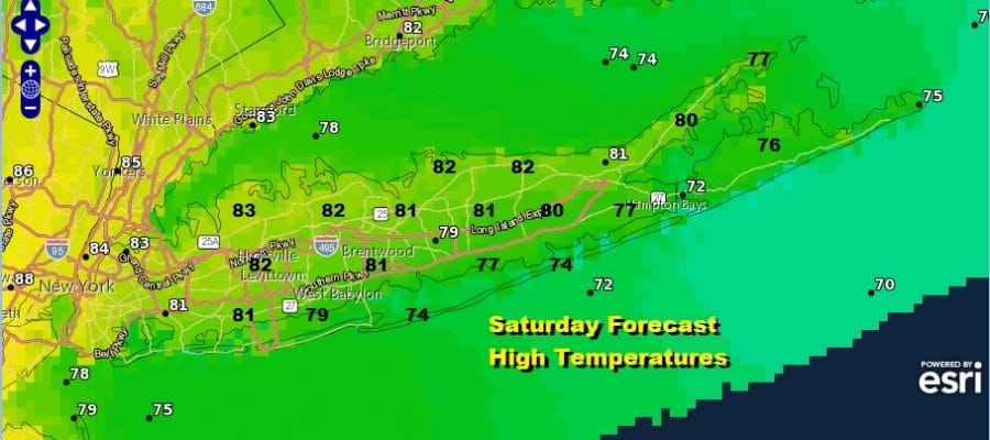
Saturday will be very warm and humid but the hot air will wait until Sunday to move in. Look for sunshine Saturday or at worst partly sunny. Highs will reach the low Northern Nassau and Northwest Suffolk County. Temperatures will be in the cooler 70s along the shore.

Sunday temperatures will be higher in the mid to upper 80s away from the ocean with 70s to near 80 at the beaches and over the East End. Again look for a partly to mostly sunny day. It will be very humid. Again just a minimal chance for a pop up isolated shower or thunderstorm, otherwise it will be a rain free weekend.

Long Island has mostly eluded the 90 degree mark so far this month. We should see 90 reached in Northern Nassau and Northwest Suffolk County beginning Monday and continuing through Wednesday. A strong upper high in the Northern Middle Atlantic will continue to produce a relatively stable atmosphere so there is little chance for a shower or thunderstorm other than an isolated pop up. Look for sunshine each day with highs reaching the 90 Monday inland and the lower 90s Tuesday and Wednesday. Temperatures will be about 10 degrees cooler along the shore. The hot humid weather will continue Tuesday though temperatures might ease slightly. Friday brings the first cold front in over a week and that will be the first real chance for a shower or a thunderstorm.
BE SURE TO DOWNLOAD THE FREE METEOROLOGIST JOE CIOFFI WEATHER APP &
ANGRY BEN’S FREE WEATHER APP “THE ANGRY WEATHERMAN!

MANY THANKS TO TROPICAL TIDBITS & F5 WEATHER FOR THE USE OF MAPS
Please note that with regards to any severe weather, tropical storms, or hurricanes, should a storm be threatening, please consult your local National Weather Service office or your local government officials about what action you should be taking to protect life and property.